ArcUser Online
Eye in the Sky
Transition from ArcIMS to ArcGIS Server makes state-of-the-art weather warnings a reality
By Matthew DeMeritt, Esri Writer
Current weather observations, lightning strike events, and storm reports—tens of thousands of new data elements used in predicting weather patterns can potentially become available each hour. AccuWeather, Inc., the leading global weather information provider, interprets this vast volume of data and issues weather bulletins to hundreds of millions of people each day via the Internet, mobile devices, print, and other media.
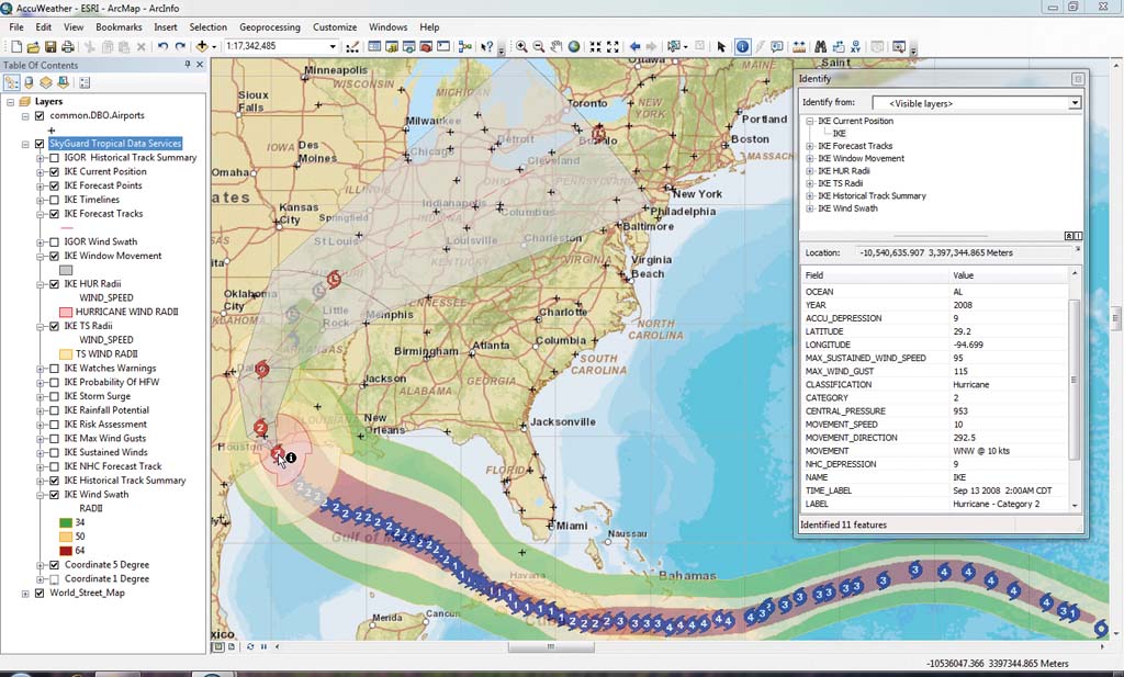
Users can easily embed SkyGuard Warnings, tropical impact forecasts, and other relevant current weather content into ArcGIS Desktop for visualization and analysis with their assets using SkyGuard data services. This map shows layers of the SkyGuard Tropical Impact Forecast Product Suite for Hurricane Ike loaded in ArcMap as a REST map service.
Businesses and consumers often require more precise weather warnings than government weather tracking systems provide. To meet that need, the more than 100 AccuWeather meteorologists use GIS to achieve the situational awareness needed to issue accurate, comprehensive severe weather alerts that help protect lives and property.
Meeting Client Demands
In 2002, AccuWeather began hosting custom Web sites for its clients using ArcIMS. Recently, the company adopted ArcGIS Server to enhance the weather content it served to customers. Initially, AccuWeather used ArcIMS to serve basic weather information. Later, the company relayed weather content and created specific products for clients with ArcIMS. According to Ethan Knocke, GIS technical coordinator for AccuWeather, that quickly paid dividends by attracting a diverse and demanding clientele who ended up pushing them harder.
"Clients saw our work and came to us with more challenging demands," said Knocke, who is also a meteorologist. "We did a lot of cutting-edge configuration of our enterprise geodatabases and their associated connectors into ArcIMS Web mapping and data services to meet these needs." AccuWeather's work with one such client earned a Special Achievement in GIS Award at the 2005 Esri International User Conference.
For years, ArcIMS performed extremely well for the weather services provider. Its GIS team developed unique techniques for converting extensive global weather datasets into GIS formats that could be loaded into ArcSDE in real time. Integrating AccuWeather's enterprise data systems with Esri geodatabases created a seamless pipeline of weather content for clients. Users could view warning informaton as live layers and other rapidly changing data elements within seconds of their acquisition in a raw format by AccuWeather.
However, the meteorological team knew GIS server technology had evolved and could take AccuWeather products to the next level. "ArcIMS served us very well, but ArcGIS Server was doing things with geodatabase management, such as open Web services, interactive Adobe Flex client-side Web mapping, and mobile application development, that we really wanted to leverage in our continuing efforts to create a comprehensive, real-time weather portal," said Knocke.
Pinpointing Threats
The U.S. government issues severe weather warnings for hazardous weather conditions such as tornadoes, thunderstorms, and flash floods. Affected areas are identified by political boundaries and issued for fixed thresholds. Consequently, an organization's assets may fall within an area identified by a government warning but may not actually be in harm's way.

SkyGuard Online, a real-time situational awareness Web application, leverages ArcGIS Server 10 and ArcGIS API for Flex to create a dynamic, interactive, and visually appealing weather portal. This image shows SkyGuard warnings in North Carolina and Florida related to Tropical Storm Nicole.
"Shutting down business when there is no actual risk from a weather situation can cost just as much as ignoring a legitimate warning and incurring weather-related damage," said Jonathan Porter, AccuWeather's manager of meteorological data. "That's why there's such demand for a pinpoint warning service like SkyGuard Warnings."
Warnings delivered through AccuWeather's SkyGuard Warnings service are based on specific criteria determined by the client and issued only when assets are in danger. SkyGuard warnings consist of point warnings applicable to locations such as schools, manufacturing plants, or corporate offices; segment warnings that relate to portions of a railroad or trucking routes; or areal warnings that cover energy grids, amusement parks, or other similar facilities.
Online Weather Portal
To generate such specific warnings, SkyGuard meteorologists closely monitor the geospatial relationship between a client's assets and pending weather threats. Warnings must get to clients quickly as a comprehensive real-time view. ArcGIS Server enabled AccuWeather to create a highly available Web-based solution for its flagship SkyGuard product called SkyGuard Online.
The online weather portal, created using the ArcGIS API for Flex, displays SkyGuard warnings, tropical impact forecasts, and other relevant information on current conditions. AccuWeather's team of meteorologists enters the data into the geodatabase, which appears in an all-in-one map viewer. Subscribers receive a secure Web portal customized to their location that supplies selected services. Customers may also upload their own data into their SkyGuard Online portal to create a centralized mashup of their assets and AccuWeather's live weather information.
"It's a real-time situational awareness tool," said Knocke. "There would have been no way to configure ArcIMS to pull all of our time-sensitive warnings and weather information into one dynamic and visually appealing interface."
Data Services: Open Data Models
ArcGIS Server also brought another level of efficiency to AccuWeather in the form of SOAP and REST services. "ArcGIS Server opened up the floodgates by providing much more flexibility with open data models," said Knocke. "Many of our clients already have deployed full GIS infrastructures and just need the missing piece—the weather content—exposed as data layers via REST and SOAP Web services."
Today, the GIS team can provide live Web services to its clients, who then integrate these services into their enterprise systems for visualization and modeling. "The geodatabase connectors in ArcGIS Server really opened the door for us," said Porter. "They enabled us to easily integrate a vast array of weather data stored in back-end relational databases into the Esri product suite."
As its visibility in the GIS space has grown, AccuWeather realized that it had to go beyond ArcIMS to meet and exceed the expectations of its client base. The SkyGuard Online weather warning portal builds on the benefits unique to the ArcGIS Server platform. Plans are currently under way for AccuWeather to enter the mobile GIS space with smartphone versions of SkyGuard Online.
About the Author
Matthew DeMeritt is a writer in Esri's Marketing Communications Department. He focuses on GIS technology and the mining industry.