ArcUser Online
Simplifying Citizen Reporting
Smartphone 311 app enhances government responsiveness
By Matthew DeMeritt, Esri Writer
This article as a PDF.
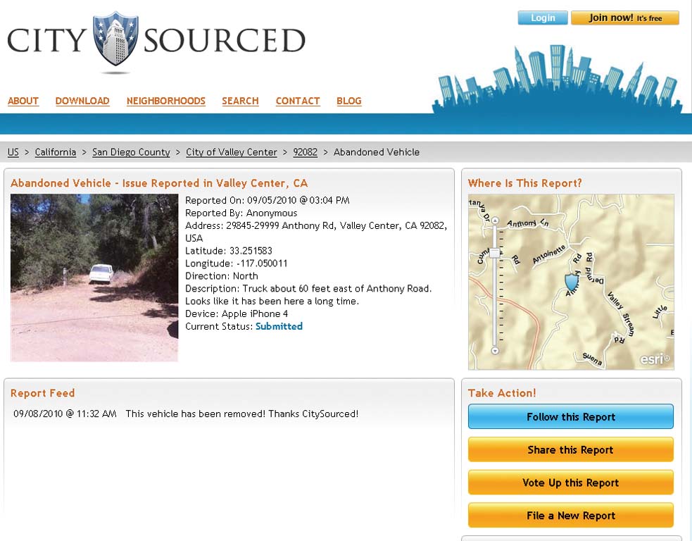
CitySourced Web site visitors can see service request reports for individual cities. This Valley Center, California, request includes the photo and status of an abandoned truck report. A variety of report types make reporting problems easy and specific. A comment field is also included for more precise reporting.
An application developed for all major smartphone operating systems enables citizens to more effectively and directly participate in local government by registering their concerns and forwarding those concerns to government work order management systems. Called CitySourced, the application was developed in summer 2009 by the company of the same name.
Many cities use GIS-enabled work order management systems to process citizen-reported infrastructure repair requests. These systems put repair incidents into prioritized queues and assign incidents to work crews. While this process is effective, a discrepancy typically exists between the number of incidents that need service and the number of reports about those incidents received. CitySourced realized that smartphones and GIS could be used to crowdsource these reports in a way that was both easier for residents and more efficient for governments.
Adding Mobile VGI to Local Government
Many geospatially enabled applications and Web sites allow laypeople to record observations that appear immediately on a map or are processed and subsequently incorporated into a feature layer. Self-described as "a real-time mobile civic engagement company," CitySourced is the latest expression of this type of crowdsourced or volunteered geographic information (VGI).
To report a local problem using CitySourced, a citizen simply takes a picture of it using the smartphone's camera, categorizes the problem using the application's pull-down menus, then submits the incident to the city's work order queue. Because GPS-enabled smartphones geotag the photos, work crews can locate the problem without requiring a citizen to enter address information—the application can automatically return a map showing the location of the incident.
The application expands the responsiveness of local government enormously. In an average city, the number of staff members in the field is fairly limited, but the number of smartphone-carrying citizens is much greater. The CitySourced app essentially turns the average citizen with a smartphone into a sensor for a city.
Service requests issued from the generic app in unsubscribed cities go straight to CitySourced's ArcGIS 10 and Microsoft Azure servers, where those requests are turned into reports and e-mailed to the appropriate city.
"That's important, because the labor budget of most cities is somewhere between 70 and 80 percent of the city's total expenditure," said Kurt Daradics, CitySourced cofounder and director of business development. "Anything that a city can do to make labor more efficient will positively impact its budget."
CitySourced also gives city executives additional insights into their jurisdictions by revealing patterns not evident in tabular work order lists. By entering data into ArcGIS Server as a transaction, cities can perform analyses on the server and identify hot spots, find trends, and see changes over time.
Daradics uses the example of a map that CitySourced recently generated for Los Angeles city council president Eric Garcetti. A simple feature layer on a map of the city showed that 80 percent of graffiti incidents were concentrated within one mile of the freeway. "That's the kind of information that will be very useful in response planning," added Daradics.
Currently, cities can avail themselves of CitySourced services using a generic application that is available for major smartphone platforms. CitySourced has one of the largest geodatabases in the United States. Service requests issued from the generic app in unsubscribed cities go straight to CitySourced's ArcGIS 10 and Microsoft Azure servers. Each service request is turned into a report and
e-mailed to the appropriate city.
All reports are delivered in Esri formats that can be easily integrated with existing GIS implementations. CitySourced developed a REST application programming interface (API) composed of REST calls utilizing POST methods. Data is returned as either XML or JSON. Cities that subscribe to CitySourced receive a customized app that directly connects citizen service requests to existing work order systems, making e-mail reports unnecessary.
A Collaborative Platform with Many Uses
To monitor and improve its bike path infrastructure, the City of Reno, Nevada, recently drafted a master plan and hired CitySourced to create a custom app that would encourage bikers and pedestrians to record the condition of the path as issues arose. The city uses the data to update its inventory and provide maps that can be used to prioritize areas in need of response.
The University of California at Davis (UC Davis) is using the app to document its compliance with the university's Stormwater Management Plan (SWMP), mandated by the U.S. Environmental Protection Agency (EPA) and California's State Water Board. Campus maintenance teams use the app to acquire geotagged photographs with date/time stamps, and other data for potential storm drain violations. This has helped facilities staff mitigate potential violations, which could cause the university to incur fines up to $27,500 a day.
The Future
CitySourced hopes to extend ArcGIS to deliver more value to its clients. Daradics is currently working on functionality for querying the operational asset layer and delivering the asset ID (e.g., streetlight #1201) into the Object field of a work order. "That way, we can ID the asset number based on a decision tree," said Daradics. "This will help automate and prioritize service requests even more efficiently by answering the question Who's in charge here? geospatially."
CitySourced's presentation during the Plenary Session at the 2010 Esri International User Conference generated great interest in mobile VGI. The company will continue working on different ways of encouraging the adoption of GIS to support the CitySourced platform. "Our mission is to transform civic engagement," said Daradics. "Transformation happens from the inside out, so we're committed to finding new ways to help our clients connect broken workflows, deliver transparency, and create more efficient feedback loops."
About the Author
Matthew DeMeritt is a writer in Esri's Marketing Communications Department. He focuses on GIS technology and the mining industry.