ArcUser Online
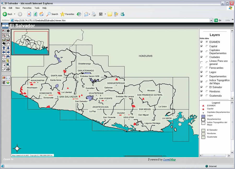
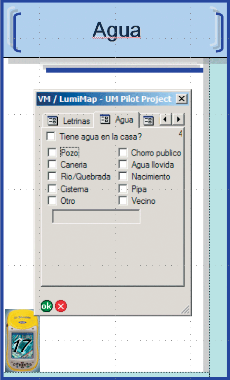
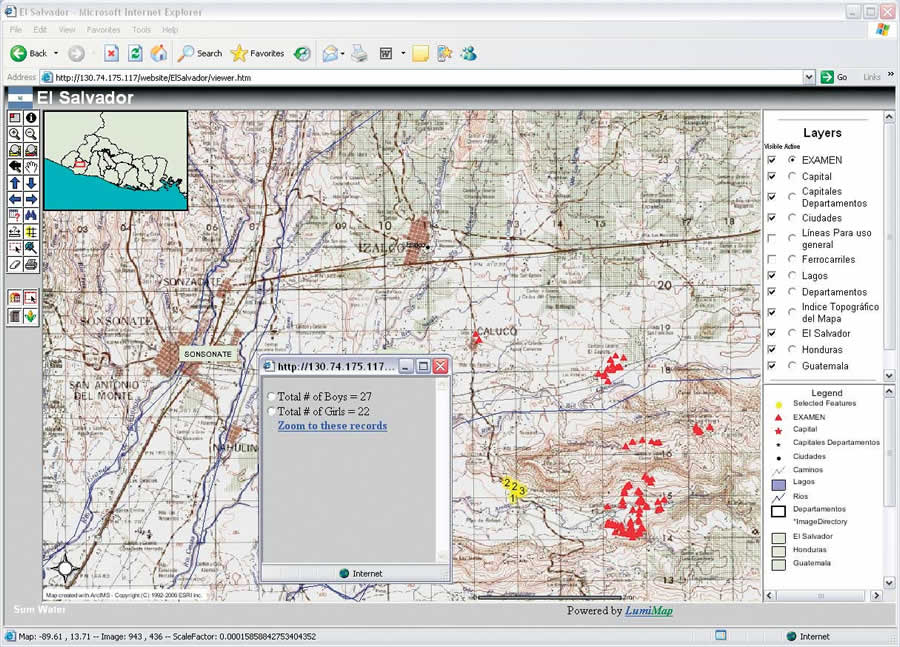
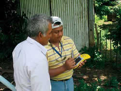
The Digital Mapping Solutions pilot project was multifaceted and included selecting and purchasing the most suitable mobile GIS/GPS technology, preparing GIS/GPS training materials and tools, creating and maintaining a GIS database, training future GIS&T users, and collecting community demographic data. In the initial stages, GPS equipment requirements were established. These requirements took into consideration the conditions under which the demographic data would be collected. Collection would be carried out for communities in widely varying geographies—from the coastal plains to the mountains to the deep rain forest of El Salvador. The Trimble GeoX series had GIS/GPS capabilities and could handle the working conditions in these environments. The LumiMap/UM team procured four Trimble GeoXM units for use in El Salvador by WV-ES staff members. An ArcPad-based digital survey form to collect the demographic data was created by the LumiMap/UM team in the United States and brought to El Salvador for training WV-ES staff. After several revisions, this form in the Spanish language was refined to its current version. The form would be used to collect data in four information categories: households, utilities (including water, electricity, sanitation, and communications), crop production, and emergency situations. An Internet mapping system (IMS) site, also in Spanish, was designed and created using Esri ArcIMS. The mapping site was populated with GIS data on El Salvador obtained from public sources and is currently hosted and administered by LumiMap/UM. This user-friendly site contains intuitive tools and several layers of information at various scales. The GeoXM GPS units were loaded with ArcPad, the ArcPad-based digital survey form, and GIS data prior to traveling to El Salvador for the start of the next phase of the project. Ironically, while traveling to El Salvador to begin training, the WV staff was delayed by two natural disasters�Hurricanes Katrina in the United States and Stan in El Salvador. These events delayed the start of the second phase of the project from fall 2005 to spring and summer 2006. Training workshops took place in San Salvador, El Salvador, in March and July 2006 and were presented in English with translation to Spanish. These workshops were attended by approximately 50 participants from different agencies in El Salvador, representatives from other WV offices in Central and South America, and WV representatives from the ADP districts in El Salvador. The weeklong training workshops included introductory lectures on the use and applications of GIS, GPS, and IMS technologies and the operation of the GeoXM devices. The workshops also included field exercises conducted in communities at risk from natural hazards such as landslides in the mountainous region and flooding in the coastal areas. Participants gained valuable hands-on experience using the GPS devices and gathering data.
The classroom training and the field exercises generated lively discussions and questions about the capabilities of the technology and its uses. These discussions helped participants understand the potential and limitations of GIS/GPS technology. The data collection process continued after the LumiMap/UM team returned to the United States, now conducted by newly trained WV-ES staff members. Since August 2006, collected data has been periodically transferred to the University of Mississippi via e-mail. The ArcIMS Web site is updated within 12 hours of receiving the data. The data collection process is ongoing and will continue until all the communities in the 16 ADP districts have been surveyed. The ResultsThis pilot project was designed to create digital mapping solutions for disaster planning and preparedness and indeed produced some tangible results. Foremost, the IMS site created allows the display of the demographic data collected in the field, information retrieval, and the printing of maps using data selection criteria. The Web site is currently being maintained and upgraded as more data is received. To support the IMS site update, there is now a finalized version of the digital survey form loaded in each of the four GeoXM units currently used by WV-ES staff to collect demographic data. Seventeen thousand data points, equivalent to the same number of households, had been collected until the end of October 2006. More than 50 WV staff members have been trained and are now capable of collecting data. The LumiMap/UM team also created a field manual for operation and troubleshooting of the GeoXM units. This field guide also explains the purpose and the questions of the digital survey form. The Lessons LearnedDuring the development of the project, valuable lessons were learned. The cost of technology in a developing country is generally higher than in the United States. However, once technology is available, people can learn how to use it rather quickly and without much specialized training.
An important aspect to keep in mind when training people about technology in general and in a developing country in particular is people's expectations. Understanding the potential and limitations of the GIS/GPS technology and how to deal with the limitations helped WV staff maintain objective expectations. On the other hand, WV-ES members participating in project activities were very enthusiastic. Workshop attendees were eager to learn how to use the technology. Many WV-ES staff members considered using the GPS devices for other purposes such as medical attention, delivery of aid, and others. Support from WV-ES headquarters, local ADP office staff, and local community leaders was very important for survey activities. Technological support from the WV-ES headquarters was necessary when problems with the GPS units arose. Help provided by the staff at the local ADP offices introducing the team to community leaders who served as facilitators was important. Local community leaders facilitated the access to community residents who otherwise would have seen the LumiMap/UM team as intruders. These local leaders took the responsibility to tell the people how the LumiMap/UM team's work would benefit them. Access to data in the developing world is rather limited; data is scarce or unavailable. Data sharing is also very limited due to the absence of cooperation between organizations that create the data and those who use it. Adding to this circumstance, if any data is made available, it may have a high cost. The experience of the Digital Mapping Solutions pilot project demonstrated how technology could be used to contribute to plan and respond to emergencies should these arise. The LumiMap/UM team was very enthusiastic about its participation in this project and considered it a very rewarding experience. AcknowledgmentsThe authors thank WVI and WV-ES staff and the staff of the local Area Development Projects that allowed the team to provide them with tools for their work. They also thank the local community leaders and the people in the communities that made it possible to find more about their lives and see their realities firsthand. For more information, contact Greg Easson, associate professor, the University of Mississippi Department of Geology and Geological Engineering, 118 Carrier Hall, University, Mississippi 38677 USA; 662-915-5995. About the AuthorsIgor Jaramillo is a doctoral student at the University of Mississippi Department of Geology and Geological Engineering and research assistant at the Geoinformatics Center. He has a master's degree in geological engineering from the University of Mississippi. This is his first experience with GIS applied to humanitarian relief efforts. He served as coinstructor in the GIS/GPS training of WorldVision El Salvador staff. Jaramillo has worked on projects involving GIS data gathering and integration into GIS systems in mass wasting phenomena, geologic mapping, watershed analysis, and river geomorphology research. His doctoral research involves the use of remote sensing imagery in natural hazards. Justin Janaskie is a master's student in geological engineering at the University of Mississippi Department of Geology and Geological Engineering and research assistant at the Geoinformatics Center. He has a bachelor's degree in geological engineering from the University of Mississippi. He is the project's Web site developer and administrator as well as technical support and contact person for data collection in El Salvador. Janaskie also served as coinstructor in the GIS/GPS training of WorldVision El Salvador staff. His master's research focuses on the use of GIS to map marine environments in deep waters in oil prospects offshore of India. Greg Easson is an associate professor at the University of Mississippi Department of Geology and Geological Engineering and the director of the Geoinformatics Center. He was the GIS workshop instructor and project principal investigator. He has worked on GIS and remote sensing research in areas such as flood and reef analysis, intelligent transportation analysis, and rapid prototyping capability of the National Aeronautics and Space Administration's Earth Observing Systems. He teaches GIS and remote-sensing courses in the Department of Geology and Geological Engineering. |
 Disaster planning and preparedness are not generally a priority in developing countries. As a result, countries seem to be particularly hard hit by the effects of natural and man-made disasters. Further, the lack of well-trained professionals in government and nongovernment institutions has limited the ability of these countries to plan, prepare, and respond to emergencies.