ArcUser Online
Spring 2011 Edition
Services Meet Management and Analysis Needs
Furnishing raster data for projects large and small
By Michael D. Sweet and John Lucotch, University of Montana
This article as a PDF.
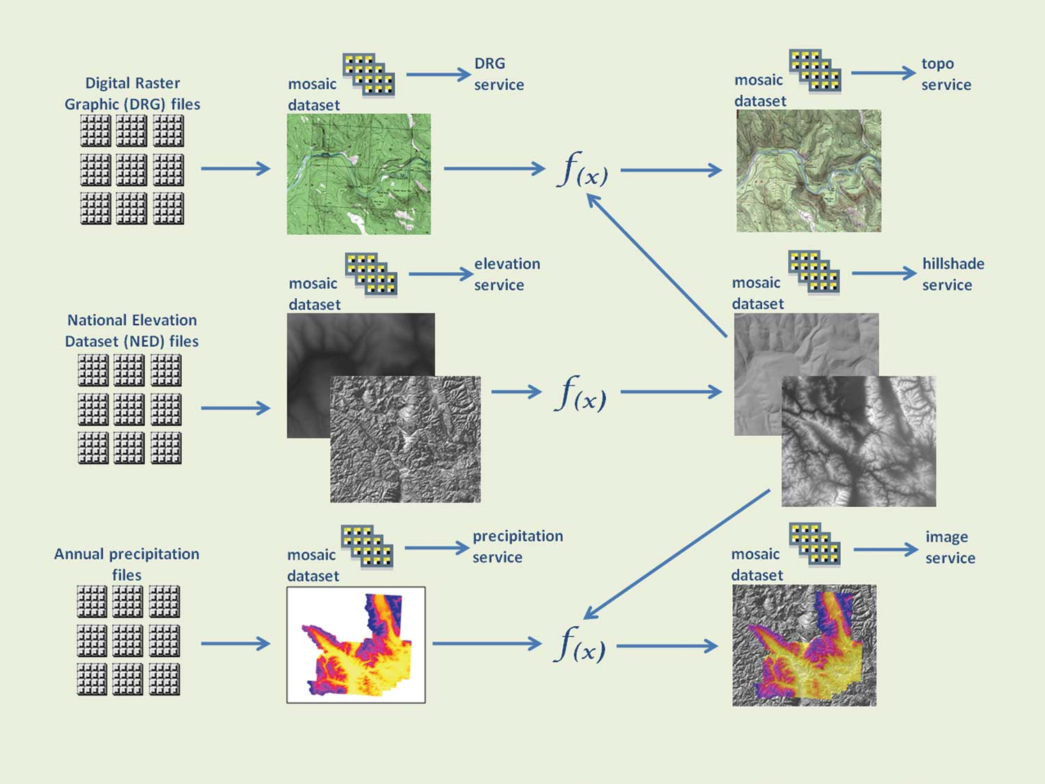
Example workflow of raw data files to mosaic dataset to service without replicating the disk storage of the raw files
The University of Montana supplies raster services for a variety of projects on platforms ranging from desktop computers to web browsers and mobile devices. Users access the university's raster data from locations across Montana and as far away as Alaska; British Columbia, Canada; and Kamchatka in the Russian Federation.
As part of a growing need for geospatial products, it has become critical to serve raster data in a timely and accurate manner. However, interacting with raster sources that vary in format, bands, data type, resolution, and extent can be challenging. In delivering raster products, it is also important to access raw raster values, not just a scaled-down representation or image of the data. By adopting ArcGIS Server 10 with the Image extension, the university was able to meet these challenges. The ArcGIS Server 10 Image extension not only serves raster data to end users with ArcGIS capabilities but can also serve raster data in Open Geospatial Consortium, Inc., Web Mapping Service (WMS) or Web Coverage Service (WCS) formats to other user communities without duplicating the source or the service.
The ability to serve large raster datasets in a virtual environment using the mosaic dataset framework is one of the most important aspects of the ArcGIS Server 10 Image extension. The University of Montana has taken full advantage of the capabilities of this extension. It adopted this virtual platform because it offered scalability and ease of maintenance. When developing imagery services on this virtual platform, it was easy to transition from the development to the production stage and meet the raster data needs of projects not only on the local campus but also forest management projects and projects carried out on a subglobal scale.
Assisting Salmon Conservation
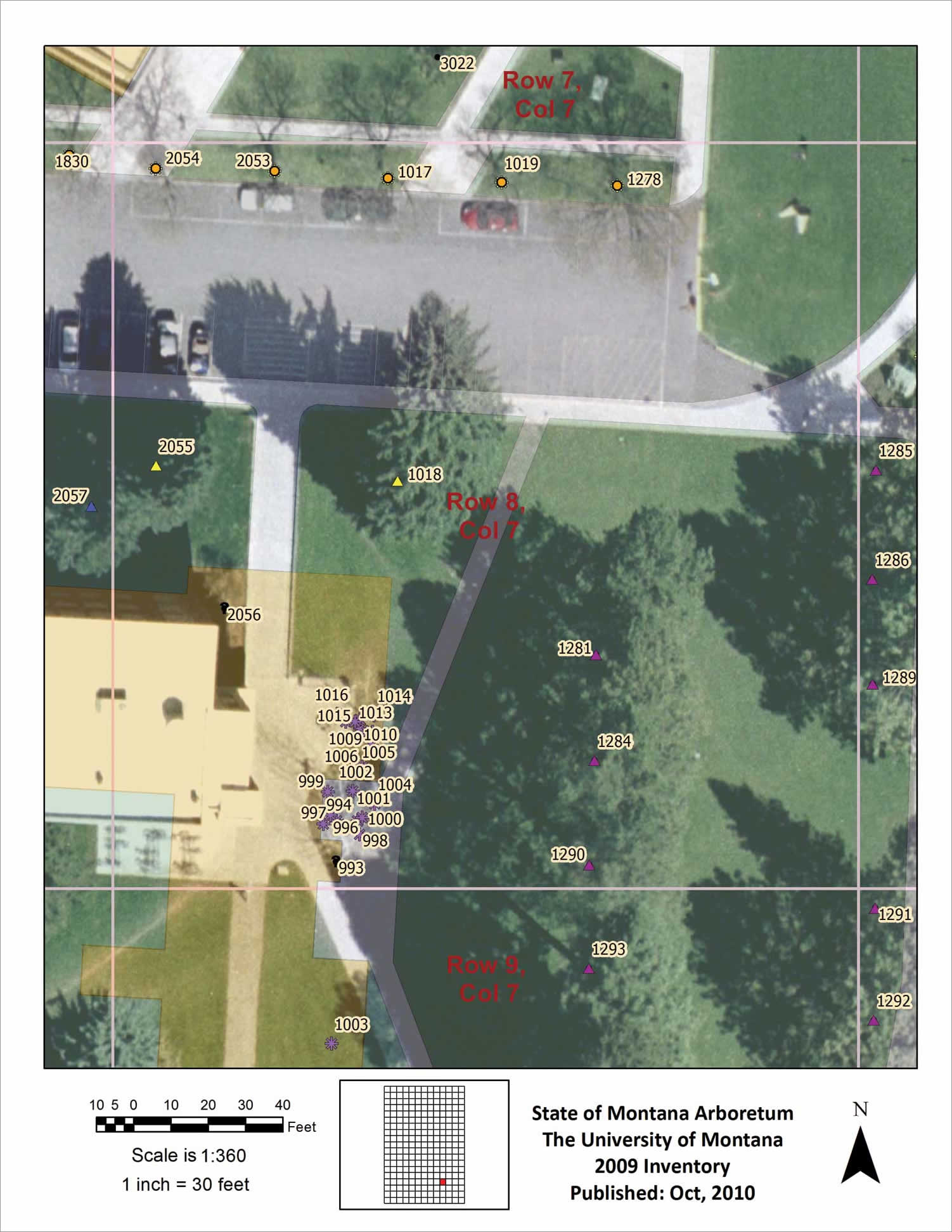
Inventory map for the State of Montana Arboretum on the University of Montana campus integrating a high-resolution image service with a campus basemap service
The Riverscape Analysis Project (RAP) provides a comprehensive geospatial database to document, assess, and compare the physical complexity of large salmon rivers across the North Pacific Rim. The two main components of this hydrological GIS analysis are satellite multispectral imagery and digital elevation models. The data includes seamless mosaics of Landsat Thematic Mapper (TM) imagery and Shuttle Radar Topography Mission (SRTM)-based digital elevation data that cover the entire domain and DigitalGlobe's nested finer-scale QuickBird multispectral satellite imagery of regional floodplain observatory sites distributed throughout the region.
The RAP system includes a North Pacific Rim domain that encompasses major North Pacific watersheds of the western United States and Alaska; British Columbia and Yukon, Canada; and the Kamchatka Peninsula in the Russian Federation.
The project objectives require seamlessly serving imagery and raster data for this vast geographic area to both internal and external clients. This data also must be served at two scales: the North Pacific Rim scale (Landsat TM and SRTM DEM data) and the floodplain scale (QuickBird data). The ArcGIS Server Image extension and the integration of the mosaic dataset let RAP view and analyze these image services. Specific examples include providing imagery and raster data for basemaps, watershed and floodplain data analysis, and time series analysis.
The RAP system uses a web-based GIS decision support system (DSS) based on the ArcGIS Server 10 framework to serve this extensive geospatial database to a broad user community. The DSS provides end users with a system for conducting real-time analyses and comparing watershed, riverine, and landscape features across the North Pacific Rim that is designed to assist in wild salmon conservation.
RAP DSS can create interactive ranking maps of freshwater physical habitats and salmon production potential. These ranking maps, based on a set of physical metrics derived from the satellite imagery, digital terrain, and other ancillary geospatial data, describe watershed, floodplain, inland water body, and river channel complexity. RAP DSS also provides tools that allow dynamic database queries and retrieval of geospatial, raster, and tabular data from the RAP database through ArcGIS Server geoprocessing tools utilizing ArcGIS Server Image extension basemaps. It also provides imagery viewers using ArcGIS Viewer for Flex applications that display Landsat basemaps, floodplain QuickBird scenes, airborne imagery, and QuickBird time series.
Interactive DSS Tool
The Subwatershed Delineation Tool is one of the main interactive features of the RAP DSS. This Python-based ArcGIS Server geoprocessing tool allows end users to dynamically delineate subwatersheds anywhere in the North Pacific Rim domain. The use of server-side geoprocessing allows simultaneous user inputs through a web browser interface that takes advantage of a multicore virtual server architecture.
This tool requires an image basemap so the user can accurately pinpoint the mouth of a given subwatershed. A Landsat TM near-infrared band image mosaic basemap served through the ArcGIS Server fulfills this need. This tool allows individuals to interact with the RAP DSS from a remote device in the field where there may be limited Internet connectivity and effectively access the RAP hydrological database, conduct fine-scale analyses, and inform on-the-spot data collection or management decisions.

Inventory map for the State of Montana Arboretum on the University of Montana campus integrating a high-resolution image service with a campus basemap service
The RAP system includes a diverse user group drawn from national and state agencies, universities, foreign institutions, researcher organizations, and corporations that have found the imagery services of the RAP helpful in identifying habitats, channel morphology, channel complexity, and land-cover change. RAP DSS, with its underlying geospatial data and the ArcGIS software framework, is flexible, modular, and designed to evolve as new data is acquired and user needs change.
Delivering Framework Layers
Montana Spatial Data Infrastructure (MSDI) efforts are directed at advancing 13 statewide framework layers. The federal government, in cooperation with other government and private sectors, has identified 7 geospatial framework data layers for the nation. In addition to these, the State of Montana designated 6 other layers.
Two of these framework layers, elevation and orthoimagery, are raster dataset products. ArcGIS Server 10 with the Image extension is the preferred mechanism for delivering this content to users. The University of Montana, which distributes and utilizes elevation and imagery products, often prototypes deployment strategies in advance of enterprise deployments throughout Montana.
These services are built from traditional sources, such as the National Elevation Dataset (NED) raster dataset and National Agriculture Imagery Program (NAIP) imagery. However, the University of Montana also utilizes many other raster data sources. Montana strives to develop the best framework product and make that product easy to obtain. The University of Montana often collaborates with other entities in the state on strategies for optimizing the utilization of software products like the ArcGIS Server 10 Image extension. This collaboration often extends to neighboring organizations such as Inside Idaho, Idaho's geospatial data clearinghouse, which also employs ArcGIS Server for delivering services.
Statewide or regional raster dataset products typically require extensive storage capacity. The university utilizes the services architecture of ArcGIS Server to minimize data duplication while still meeting the analytic and display needs of users. From a storage management perspective, the ArcGIS 10 environment offers the ability to move effortlessly from raw raster files to a mosaic dataset to an image service with no duplication of files. It requires little overhead to deliver seamless statewide raster products. Using the mosaic dataset, generalized overviews at varying scales can be generated from a collection of raster files and served using the ArcGIS Server 10 Image extension. This provides a visual presentation of the full extent of the source data while still making raw values available for analysis or query.
Through the Image Analysis window in ArcGIS Desktop 10 and other geoprocessing tools, users can manipulate the raw raster values served through ArcGIS Server as if the data resided locally. Using the tools in the Image Analysis window to create a subset of data from a service is far more intuitive than working with the complex processes associated with handling raw image files. Users aren't constrained; their analytic or display needs can be met using these raster-based services.
The ability to develop new services by integrating existing services is an important aspect of this service-based architecture. Alternative outputs are derived in real time from the same source. Slope, aspect, hillshade, and topographic convergence services can be derived from a single elevation service without duplicating data. This concept of reference mosaic datasets extends to combining a hillshade service with a simple basemap service to create a topographic basemap service. This service of services approach is not only highly efficient, it retains the workflow. If one of the components in the workflow is enhanced, all downstream components immediately benefit from that enhancement without having to be re-created. Image services published through ArcGIS Server 10 Image extension are also a recognized data type within the mosaic dataset.
The University of Montana also hosts the Montana Climate Office, which is pursuing the delivery of statewide climate products. Time is a component of climate, and the ArcGIS 10 environment supports time at both the desktop and service levels. Delivering raster-based time series climate data gives the end user the capability to query the service based on time. The Montana Climate Office is anticipating the production of statewide climate products on a daily basis. Meeting user expectations would be extremely difficult without time-enabled raster services provided through the ArcGIS Server 10 Image extension and the efficiency of ArcGIS Desktop 10 products in utilizing those services.
Support for Smaller Projects
The deployment of raster services does not always have to be large in extent or complex. The University of Montana also hosts the State Arboretum on the Missoula campus. The arboretum uses the City of Missoula's 4-inch resolution imagery, as well as historic imagery, to document change over time.
Correctly configuring image services for even small raster collections can boost delivery performance for end users. Through image services, imagery can be provided to other campus users in other domains without giving them direct access to source files. In addition, the same mosaic dataset used as input to an image service can also be used as input to a map service. This provides the foundation for delivering services that merge lower-resolution imagery outside the extent of the City of Missoula imagery. From the user perspective, this provides a seamless visual context and leverages high-resolution or higher-quality imagery where it exists. In the near future, this same foundation will support delivery to mobile devices and even virtual tours of the State Arboretum.
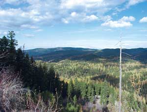
The Lubrecht Experimental Forest is a 28,000-acre operational and research forest dedicated to the advancement of natural resource knowledge through research and education.
The University of Montana also hosts the Lubrecht Experimental Forest, a 28,000-acre operational and research forest. This location has limited Internet connectivity, so the ability to provide offline access to cached imagery is an important consideration for field operations. Even more important is the ability to deliver operational information via services hosted on the main campus. An extensive lidar research effort produced high-resolution raster datasets for ground surface, canopy cover, and canopy height. These high-resolution datasets can be delivered to remote operations even though both internet and intranet connectivity is less than ideal.
The use of ArcGIS 10 offers a software environment that reduces the overhead in delivery of raster datasets that vary in format, bands, data type, resolution, and extent. It provides a richer experience to end users who operate under a wide variety of conditions and enables a foundation of services that can be leveraged as new needs arise.
About the Authors
Michael D. Sweet is a research and information systems specialist at the University of Montana. He is a GIS analyst and principal architect of geographic information server applications for the College of Forestry and Conservation. Sweet is also an analyst for the Montana Climate Office, where his current research interests include the efficient delivery of time-series climate data for decision support.
John Lucotch is a research associate in GIS and geospatial analysis at the University of Montana. He is currently overseeing administration of ArcGIS Server and ArcSDE for the Flathead Lake Biological Station and the Riverscape Analysis Project. His research includes the development of Python ArcGIS geoprocessing applications and web mapping applications for web-based GIS decision support systems. The Riverscape Analysis Project can be found online at rap.ntsg.umt.edu.