ArcUser
Spring 2012 Edition
5 Reasons to Use ArcGIS for SharePoint
By Derek Law, Esri Product Management
This article as a PDF.
Two quick questions for GIS managers reading this article:
- Does your organization have Microsoft SharePoint as part of its information technology (IT) solution?
- Are your SharePoint users aware of the benefits of visualizing their business data in a spatial context?
If you answered yes to the first question and no or maybe to the second question, Esri has developed a way you can easily add GIS mapping functionality onto SharePoint pages and empower your SharePoint users with geographic information.
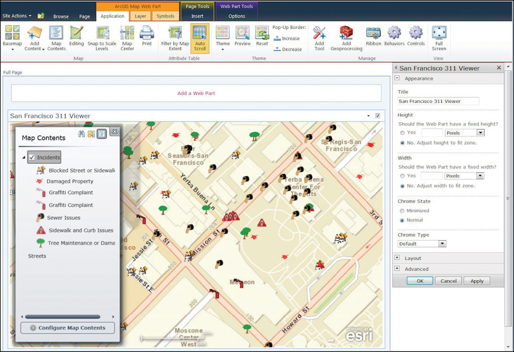
ArcGIS for SharePoint has an interactive Map Web Part.
What Is ArcGIS for SharePoint?
ArcGIS for SharePoint is a set of components built on the award-winning ArcGIS API for Silverlight and enables you to quickly and easily incorporate GIS functionality into SharePoint sites. ArcGIS for SharePoint recently won the 2011 Visual Studio Magazine Reader's Merit Award in the SharePoint Tools and Components category.
By installing ArcGIS for SharePoint onto a SharePoint farm, you enable the SharePoint platform to become a client application that can work with ArcGIS for Server web services and ArcGIS Online web maps. It also enables SharePoint lists containing spatial data to be displayed in a geospatial context. In effect, ArcGIS for SharePoint provides a geospatial dimension for SharePoint site content.
ArcGIS for SharePoint consists of three components: the Map Web Part, the Geocoding workflow, and the Location field.
The Map Web Part is an interactive map that enables the display of ArcGIS for Server and ArcGIS Online services, web maps, and SharePoint lists with spatial data. The web part is configurable and includes many core GIS mapping functionalities such as data display, map navigation, query and search, printing, and data editing.
The Geocoding workflow enables SharePoint lists containing spatial data (e.g., addresses or x,y coordinates) to be easily displayed in a spatial context. The workflow can be set up as part of a business workflow. For example, when the SharePoint list is updated, the corresponding displayed spatial data could be automatically updated.
The Location field is a custom data type used in SharePoint lists that enables records containing spatial data to be shown in a geographic context. It is typically used with the geocoding workflow. When a workflow is applied to a SharePoint list, the workflow adds a location field to the list, which displays the data on a map.
ArcGIS for SharePoint supports the latest capabilities offered by ArcGIS for Server and can be installed on Microsoft SharePoint Server 2010 or Microsoft SharePoint Foundation 2010. The Microsoft Silverlight plug-in needs to be installed in the web browser that is used to access your SharePoint pages.
Why You Should Use ArcGIS for SharePoint
Now that you know what ArcGIS for SharePoint is, here are five very good reasons you should consider using it.
Reason 1: It provides GIS and interactive mapping functionality in SharePoint sites.
ArcGIS for SharePoint adds a geospatial dimension to both working with and collaborating on SharePoint site content. It highlights the value of visualizing data spatially, something SharePoint users may not be aware of. SharePoint lists containing spatial data can be easily displayed in a spatial context and used with web services from ArcGIS for Server and ArcGIS Online for further GIS analysis. ArcGIS for SharePoint can use GIS functionality, such as buffering, overlay analysis, and network routing, by accessing geoprocessing services from ArcGIS for Server.
SharePoint analysts typically work with large amounts of tabular data and use key performance indicators (KPIs) to identify and assess patterns and trends. The Map Web Part provides an interactive map display with many GIS mapping capabilities included out of the box. This significantly different reporting approach enables SharePoint analysts to visualize and analyze their business data in a more revealing format—a map. ArcGIS for SharePoint can be easily integrated into an organization's larger business intelligence solution built on the SharePoint platform.
Reason 2: It's easily configurable to meet business-specific needs.
Both the Map Web Part and the Geocoding workflow in ArcGIS for SharePoint have been designed to support users who are already familiar with configuring SharePoint parts and workflows. Both have an intuitive GUI point-and-click user experience. The Map Web Part offers both a design-time and run-time view of its interface, while the Geocoding workflow can be set up by following a simple wizard.
This means that SharePoint users who are not GIS analysts can learn how to work with and leverage the ArcGIS for SharePoint components in a short time frame. No programming or configuration file editing is required to work with these components. Users can quickly customize the components to meet their business requirements.
Reason 3: It helps GIS departments sell the value of GIS to an organization.
Organizations with GIS departments that already use ArcGIS for Server and ArcGIS Online can leverage ArcGIS for SharePoint to help promote and distribute their own work (and the value they bring to the organization) to other departments. ArcGIS for SharePoint can help elevate the use of GIS inside an organization.
ArcGIS for SharePoint helps extend the reach and usage of GIS services within an organization because it brings GIS to parts of an organization that may not directly use GIS but do use SharePoint. Some parts of an organization may not yet recognize the value of visualizing data spatially, and ArcGIS for SharePoint helps promote this paradigm. This is especially relevant as the usage of SharePoint continues to grow as an internal content management and collaboration system within many medium to large organizations.
Reason 4: It's extensible.
ArcGIS for SharePoint is built on ArcGIS API for Silverlight. Its Map Web Part can be extended via its lightweight and flexible extensibility API. For developers, the API provides access to the map component and its selected layers, which offer several points of interaction for customization.
In addition, you can include an extension to the Map Web Part that is open-ended and provides additional custom functionality. Within an extension, you may leverage any Silverlight library, including ArcGIS API for Silverlight and the native Silverlight API. You can manipulate the map and layers, display any Silverlight UI, make your components configurable, interact with other Silverlight or JavaScript components on the page, make calls to web services such as those provided by SharePoint or ArcGIS for Server, and much more.
Reason 5: It's available at no extra cost.
ArcGIS for SharePoint is available as a free download for existing ArcGIS for Server users. This set of components for SharePoint is provided at no extra cost. If your organization has ArcGIS for Server and SharePoint, why not leverage ArcGIS for SharePoint as part of your IT solution? ArcGIS for SharePoint, frequently updated to support the latest ArcGIS for Server capabilities, is fully supported by Esri. Users can call Esri Support for technical assistance if needed.
Resources
More ArcGIS for SharePoint product information is available on the Esri product pages. The ArcGIS for SharePoint Resource Center is your main source of additional information about ArcGIS for SharePoint. It contains links to the download package, help and developer documentation, code samples, and support forum—all the resources needed to start working with ArcGIS for SharePoint.