The World Bank, a cooperative of 187 member countries, provides financial and technical assistance to developing countries around the world to help reduce poverty.
Conventional governance methods can’t cope with the speed and scale of the technological, social, and environmental changes sweeping the world. Governments and international development organizations have to adopt a more holistic approach to the challenge—in essence, to draw up a “business plan for the planet.”
Such a plan would require a comprehensive redesign of economic policies, broadening the way we calculate national products and services. It would include a more comprehensive form of wealth accounting that puts quantifiable values on natural capital and ecosystem services. The least developed countries need investment flows to speed up green and inclusive growth, while middle-income countries need to shift the pattern of their growth with resource efficiency and inclusivity at the fore. The developed world needs to play its part by shrinking the footprint caused by inequity and resource inefficiency. It’s a global business plan for a multispeed world.
This can only be achieved with better data and, more important, the better application and use of that data. Data without purpose is clutter. We have learned over 65 years of serving our clients that, to be effective, development programs must be based on firm evidence and driven by reliable data.
Since the first Earth Summit in Rio de Janeiro 20 years ago, the debate on sustainable development has shifted focus to the sustainability of growth. Growth is essential for poverty eradication, but for growth to be sustainable, it needs to be greener and more inclusive.
Climate change threatens to undo much of what we’ve accomplished for the poorest and most vulnerable in developing countries and sharpens the need for integrated solutions across the economy. We calculate that climate change is already costing Africa 5 percent of its gross domestic product (GDP) growth per year. The need to find solutions that improve food security, provide energy access, balance water supply and demand, can cope with rapid urbanization, and bring climate adaptation to the fore demand lateral thinking and planning.
With these challenges, no country can afford the luxury of not empowering its most significant market and productive sector: women. In some countries in Africa, women compose the majority of small farmers and business owners, but access only about 5 percent of the bank credit. Underinvesting makes no sense.
The good news is that technology exists to enable more evidence-based, data-driven development. Technology is evolving rapidly, and data is becoming more accessible. Technology can become a source of empowerment that improves and strengthens growth programs through popular engagement.
We at the World Bank value open, accessible data and believe in its effectiveness. We have seen that it can help reduce poverty, restore ecosystems, and generate growth. Of key importance, though, is how data is collected; who keeps, analyzes, and shares it; and how this is done. At the bank, one of the most important tools for collecting, applying, and sharing data is GIS.
We have used GIS operationally since the early 1980s. Many teams are using and developing GIS tools and maps for a wide range of applications including assessing the viability of current development projects or the location of planned ones. A map might show human settlement densities in a country relative to its clinics, hospitals, and schools to indicate areas of greatest need. A map could also be used to ascertain that there are sufficient service roads in the right places. Or a map could help determine how many people are at risk from flooding or earthquakes.
Projects benefiting from such spatial analyses include the bank’s Climate Change Knowledge portal. In addition, the bank’s spatial development infrastructure team has set up a high-priority rapid-mapping service for its natural disaster risk management situation room. A series of 49 interactive, country profile maps shows climate change priorities. The bank also performs urban growth analysis for more than 100 cities worldwide using remote sensing.
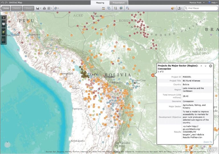
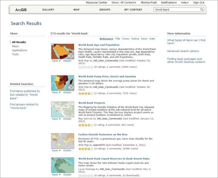
The World Bank Institute’s Innovation Team has geocoded and mapped more than 30,000 geographic locations for more than 2,500 bank-financed projects worldwide under its Mapping for Results initiative. All new World Bank projects are now georeferenced to ensure that development planners can track and deliver resources more efficiently and effectively and avoid work duplication. Since the data is publicly accessible, it also empowers citizens to follow the progress of projects and service delivery in their countries.
The bank’s Development Research Group uses GIS methods extensively to carry out policy research and provide support to bank operations. As part of its environmental policy research, the bank uses overlay mapping techniques to track the spatial distribution of potential environmental impacts and calculate the probable effects of climate change.
In our Global Facility for Disaster Reduction and Recovery (GFDRR), geospatial risk assessments are central to the World Bank’s disaster reduction strategy. The bank does not engage directly in disaster response but focuses on risk reduction. In the event of a disaster, we do assist humanitarian agencies and postdisaster reconstruction (as in Haiti after the January 2010 earthquake). GFDRR has identified 31 priority countries deemed most at risk of disasters. The GFDRR lab has magnified its impact by inviting specialists in GIS and related fields to help map risk profiles in these countries under the Open Data for Resilience program.
Meanwhile, many countries are turning to GIS for planning and service delivery. Ghana is using GIS to map its extractive industries and assess their economic value. Jamaica has embraced the technology for similar reasons. Mali is using GIS to help adapt to the challenges of climate change. GIS has also helped revitalize Rwanda’s coffee-growing industry. The value of GIS in poverty reduction was thoroughly explored in the World Development Report 2009 entitled Reshaping Economic Geography.
Cost was a major inhibitor in the early use of GIS. But, as the technology has become more affordable and commercially available, its use has expanded exponentially. Many proprietary technologies that used to be prohibitively expensive are now open source. The World Bank itself has opened many of its data banks to public access. It is crucial for the sustainability of GIS that its data is not lost but becomes permanently incorporated into national and international operations as spatial data infrastructure.
To an increasing degree, governments, aid agencies, and commercial enterprises are joining forces around GIS technology, particularly on issues, such as climate change, that are too big and complex for any one institution to handle. The World Bank recently entered into a partnership with the European Space Agency to incorporate satellite data—under the rubric Earth Observation for Development—into the bank’s lending operations in sustainable development.
Collaborations such as these are bound to grow as more organizations tap into the power of GIS. This will bring the data necessary for a business plan for the planet one step closer to reality.
About the author