ArcUser
Spring 2012 Edition
Looking Up for Answers on the Ground
Providing first responder maps for the 2011 Japanese earthquake and tsunami
By Karen Richardson, Esri Writer
This article as a PDF.
A professor of anthropology used his remote-sensing expertise, developed exploring ancient cultures, to aid emergency response to the Tohoku earthquake and tsunami.
Dr. Terance L. Winemiller, GISP, associate professor of anthropology and geography at Auburn University, Montgomery (AUM), in Alabama, took his first GIS course while in graduate school. His interest in geospatial technology led him to become a specialist in remote sensing. He found GIS was the perfect tool for interpreting ancient cultures by constructing maps of archaeological sites that had never been mapped before. Employing total stations and GPS collectors, he gathers data he uses to construct maps in ArcGIS in both two and three dimensions.
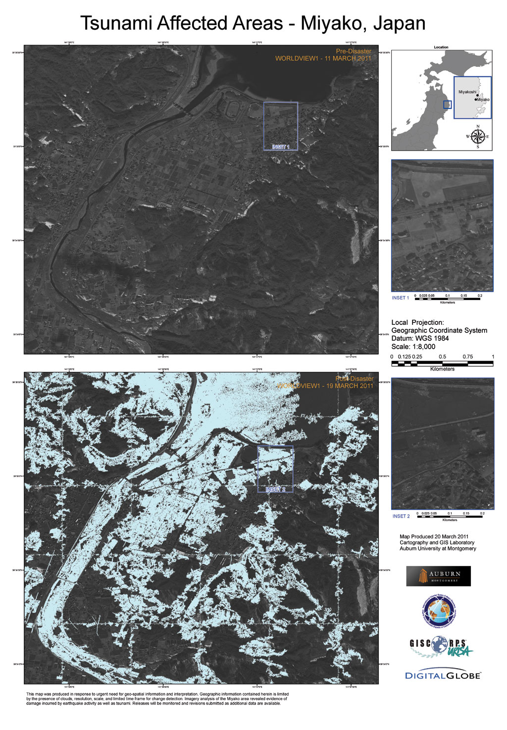
Winemiller's team processed vast amounts of data from a variety of sensors and platforms. Imagery analysis of the Miyako area revealed evidence of damage incurred from earthquake activity as well as tsunami.
His interest in mapping led him to develop a GIS program at AUM in 2004—the first at the university. Today the program includes as many as eight courses for bachelor and master programs. A site license provides students with access to Esri software.
A Call to Action
On March 11, 2011, a powerful 9.0-magnitude earthquake hit Japan, unleashing a massive tsunami that crashed into Japan's northeastern coast, resulting in widespread damage and destruction. Japanese officials soon realized that they needed to understand the extent of the damage in order to help their citizens. Satellite sensors provide global coverage so the damage caused by natural disasters can be assessed using current and historical imagery. The worldwide remote-sensing community was asked to help.
When a major disaster strikes, the International Charter on Space and Major Disasters takes effect. This charter, first initiated by the European Space Agency, provides space satellite data to relief organizations responding to these events. The US Geological Survey (USGS) was as part of the US team of signatories to this charter. USGS, working through GISCorps, an organization composed of GIS professional volunteers, requested help processing and analyzing imagery from Japan. Winemiller, along with Christopher Blair and Sissy Speirs, two student assistants who gave up other plans for their spring break, volunteered, and AUM became one of four universities in the United States that helped process and analyze imagery related to the disaster.
Efficient Workflow When Every Second Counts
Winemiller was given access to more than 1,200 different imagery datasets. Less than two days after the disaster, the team began working on the project. They searched for imagery on the USGS Earth Resources Observation and Science (EROS) Hazards Data Distribution System (HDDS) public and restricted databases and public sites for coverage of the three areas in Japan they were assigned: Miyagi-Kamaishi, Iwate-Miyako, and Iwate-Miyakoshi.
"We were looking for images of both pre- and postdisaster to understand the changes that occurred and the amount of damage that was done," said Winemiller. "We studied the geology of the areas we were assigned to assess earthquake damage and, of course, damage from the tsunami, which was the easiest to identify."
Time mattered. Winemiller's team had to sift through and process vast amounts of data from a variety of sensors and platforms. They needed to easily process and analyze this imagery and produce detailed maps. They chose ENVI image analysis software for image processing and image analysis and ArcGIS for GIS analysis and mapping production.
The automated image preprocessing tools in ENVI were used to prepare the imagery for viewing and additional analysis within ArcGIS. Imagery was resampled to create a uniform pixel count and pixel size so different images could be registered and fused together. Subsetting cropped images to focus them on areas of interest. Georeferencing established the correct position of an image relative to other images or on a map. Building a mosaic combined multiple images together into one larger scene.
After enhancement in ENVI, the images were pulled into ArcGIS to create before and after insets from the layouts of the same locations. From these insets, they created maps. The maps were uploaded to USGS, which provided them to first responders on a secure server.
"Some of the locations in Japan had little or no communication after the disaster, so the responders had no idea what was going on there," said Winemiller. "We found the layout capabilities of ArcGIS 10 to be the perfect tool because it was user-friendly, making it easy to pull in imagery. I don't think we could have done this with any other solution."
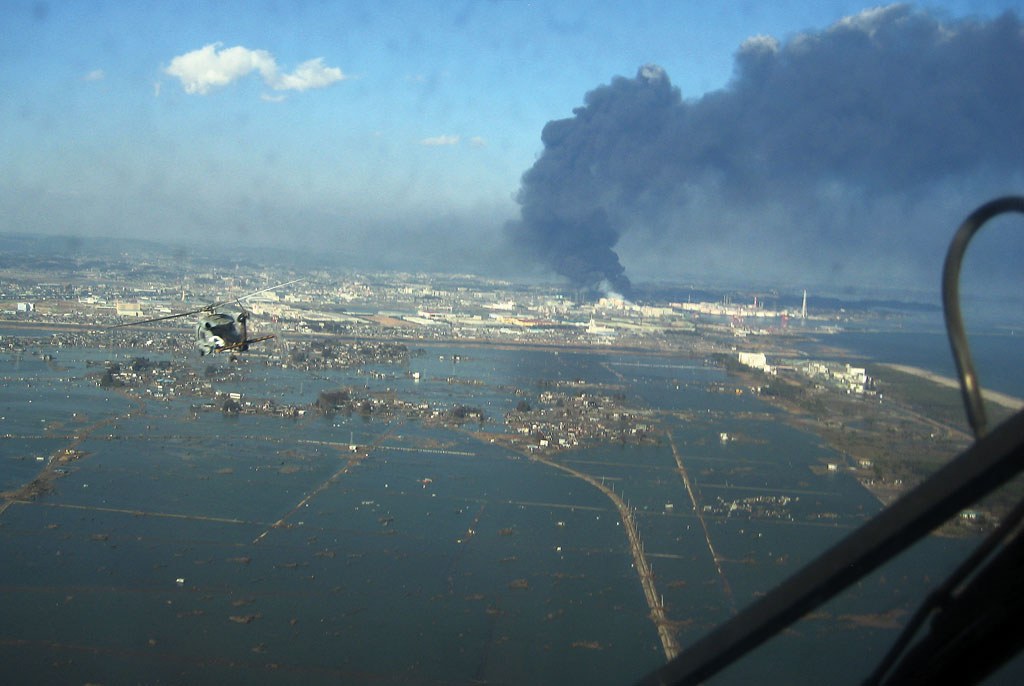
US Naval helicopters deliver food, donated by the city of Ebina, Japan, to survivors of the earthquake and tsunami. (Photo courtesy of the US Navy/Released Official Navy Photos, used under Attribution Common License)
Many Imagery Sources
Imagery for this project came from sensors aboard IKONOS, SPOT, WorldView-1 and -2, QuickBird, Landsat, and many other satellites. First, the team looked through the imagery to determine coverage and see if the imagery could be used for this mission. They opened files in ENVI, which supports panchromatic, multispectral, hyperspectral, radar, thermal, and lidar imagery types. Winemiller and his students soon realized that a large percentage of the imagery required enhancement to improve clarity. They matched up images from different sources pixel for pixel and linked them together to create rasters that accurately mapped areas for damage assessment.
The need to get imagery to responders on the ground as quickly as possible limited opportunities for performing detailed image analyses. Initially, visual comparisons of the processed before and after scenes were performed to identify the areas with the most damage. Later, Winemiller used the feature extraction tool in ENVI on pre- and postearthquake imagery to identify grids, building footprints, and other items to more accurately compare images.
After the images were processed in ENVI, the team output the images as GeoTIFFs and imported them as datasets into ArcGIS, where the detailed maps were created using the enhanced and processed imagery. ENVI's advanced image analysis tools are also available directly from the ArcGIS environment for users who wish to access them through either a desktop or server environment. "The workflow between ENVI and ArcGIS was a piece of cake," said Winemiller.
Getting Maps to Responders Quickly
Satellite imagery has become a major component of postdisaster relief efforts like the one in Japan. The global coverage of satellite sensors makes them ideal for providing the imagery required when time is at a premium after a disaster.
Within 36 hours after the first request, Winemiller and his team of students had useful maps showing accurate pre- and postevent information so damage could be assessed. "Using satellite imagery with this solution enabled us to create up-to-date maps providing emergency responders in Japan with the critical situational awareness they need to understand which areas were affected, what the damage extent was, and what resources were needed," said Winemiller. "We were happy to help our global neighbors and provide our students with a terrific learning opportunity involving a real-world situation."
For more information, contact Dr. Terance L. Winemiller, PhD, GISP, at 334-244-3945 or twinemi1@aum.edu.