ArcUser
Spring 2012 Edition
Photogrammetric Modeling + GIS
Better methods for working with mesh data
By Rachel Opitz, University of Arkansas, and Jessica Nowlin, Brown University
The method of bringing photogrammetric data into a GIS to create simple visualizations described in this article is being used in ongoing University of Michigan excavations at Gabii, Italy.
This article as a PDF.
The authors describe how to bring photogrammetrically derived meshes into a GIS so that the 3D relationships between features can be easily understood, descriptive data can be integrated, and spatial analysis tools in GIS can support analysis and interpretation after the field project has ended.
Photogrammetric Survey in Archaeology
Close-range photogrammetric survey is increasingly popular as a recording method in archaeology. Photogrammetric survey uses a series of photographs of an object to deduce and accurately model its geometry.
This technique is commonly used to document features with complex geometries or large numbers of inclusions, including walls, pavements, rubble collapse, and architectural elements. These types of features can be quite time-consuming to document thoroughly by hand or using conventional surveying in the field.
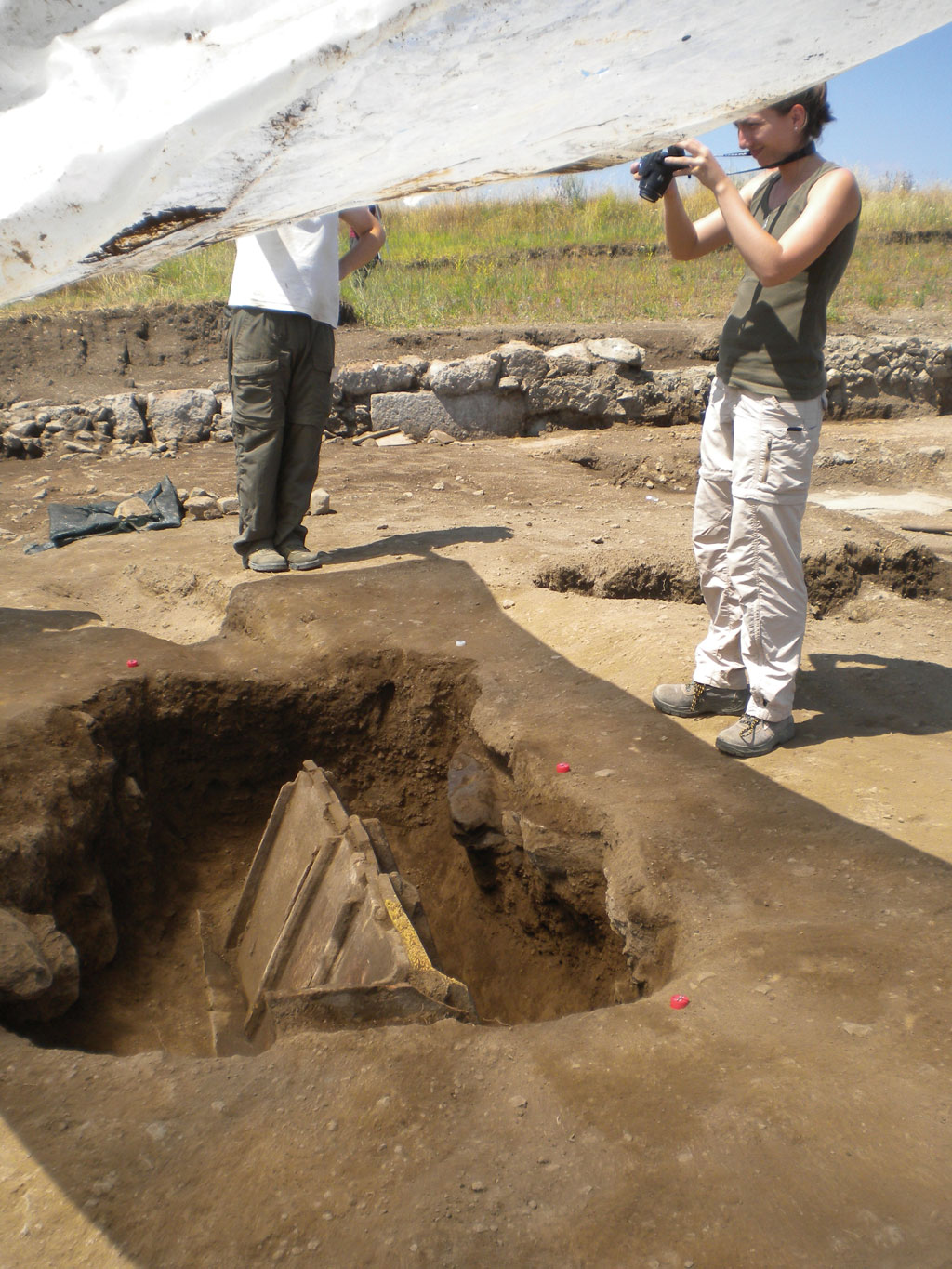
The use of photogrammetric recording can greatly benefit projects by saving time and creating a visually rich final product. Photogrammetric models might be used in excavation to record a complex sequence of walls or a tomb or on a survey to document the environment around a rock art panel.
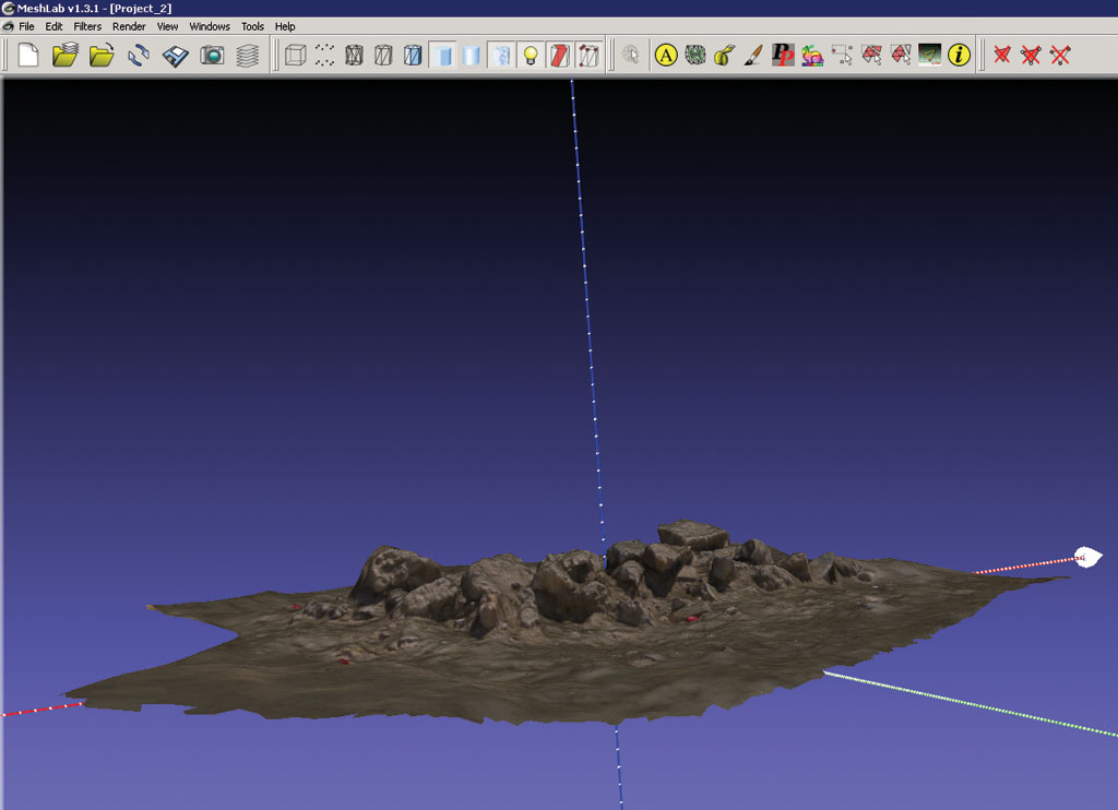
A textured mesh of a typical archaeological feature, a pile of rubble, viewed in Meshlab
Photogrammetric models are typically assembled and processed in specialized software including PhotoModeler Scanner, Autodesk's 123D Catch, and Agisoft's PhotoScan. Information on photogrammetric modeling is available from these companies.
A typical final product from a photogrammetry project is a textured polygonal mesh combining color and geometry data. In archaeology, the geometry of the features recorded is often complex, and both the position and shape of these features are important, so keeping the data in a mesh format—designed to handle complex geometries—is desirable rather than converting to a simpler geometry type or a voxel model. [Voxel models use elements that represent a value on a regular grid in three-dimensional space.]
Looking at these models on their own can be useful, but to really exploit their potential, they should be viewed in context along with other data, such as survey data, photos, descriptions, and models of adjacent features that are collected in the course of a project.
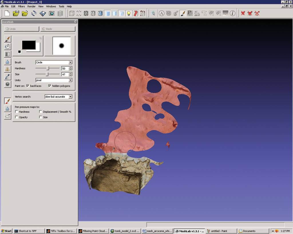
Working in Meshlab, unwanted polygon faces are selected and deleted.
Why Manage Photogrammetric Models in ArcGIS?
Many excavations already use ArcGIS to manage their spatial data and maintain links with other relational databases containing information such as stratigraphy, environmental data, ceramics, and osteology. Managing the results of photogrammetric surveys within an existing GIS environment is a practical solution to the problems of organizing, visualizing, and creating documentation from the 3D models. Bringing the models into a GIS facilitates the integration of photogrammetric and conventional survey data, making it easy to place the photogrammetric models in their proper locations. Finally, storing the models in ArcGIS allows archaeologists and managers to continue to work in a familiar software environment.
The Basic Process
Much of the work required to bring photogrammetrically derived meshes into a GIS involves the production of a clean mesh. Once this is achieved, importing the mesh into the GIS is straightforward using the tools provided through the ArcGIS 3D Analyst extension. The creation of related information (making polygonal models of individual features, adding written descriptions, associating finds or sample data) can take advantage of GIS functionality for connecting to relational databases and managing attribute data.
Top-up digitizing tasks, like producing a georeferenced sketch of a skeleton, are done using the photogrammetric model, snapping the polygons to the mesh while outlining individual bones.
The process of bringing photogrammetric data into a GIS and using it to create some simple visualizations is outlined here using an example from the ongoing University of Michigan excavations at Gabii, Italy. There are three phases for the ingestion of each model: the creation and cleaning of the mesh; proper formatting for import into the GIS; and geolocation of the mesh, along with the creation or linking of related information and metadata.
The Initial Mesh
The mesh produced by photogrammetric modeling software will be (substantially) internally consistent but without real-world coordinates or a sense of orientation. ArcGIS does not support editing individual nodes or faces of a multipatch, so it's essential that you clean the mesh data before importing it. Closing holes, removing any areas of extraneous data, and despiking are all done at this stage. There are a number of commercial and open source software packages designed for mesh editing. Meshlab, a popular open source product for mesh creation and editing, is being used for the Gabii Project.
Export from Modeling Software
ArcGIS imports both VRML and COLLADA format files. Most photogrammetric and mesh editing software packages export to these formats. To minimize file sizes and improve performance, export files without color or normal data appended, as ArcGIS only uses the texture files.
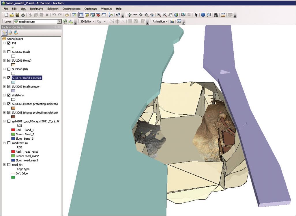
The relationships between features are easily communicated through visually rich models.
Creating good texture data is an important part of making models look right. Large, high-quality textures will look good but likely cause navigation to be slow and jumpy. Producing optimized textures, including enough detail to support interpretation but without slowing navigation on-screen, is therefore an important step. Using optimized textures where possible can make a big difference in the performance of the final model.
Import and Transformation: 3D Pseudoreferencing
Mesh data needs to be aligned with surveyed data to get the models into their real-world locations. One approach is to survey in points on targets that appear in the photogrammetric model. Another approach is to survey in key components or a simplified outline of the feature in question, to which natural features in the model can be aligned. For good results, at least three reference features distributed across the model are needed.

The imported mesh is aligned with surveyed reference targets (green points and red bottle caps), and its alignment with surrounding features is checked.
Related Data: Creating Features on the Mesh
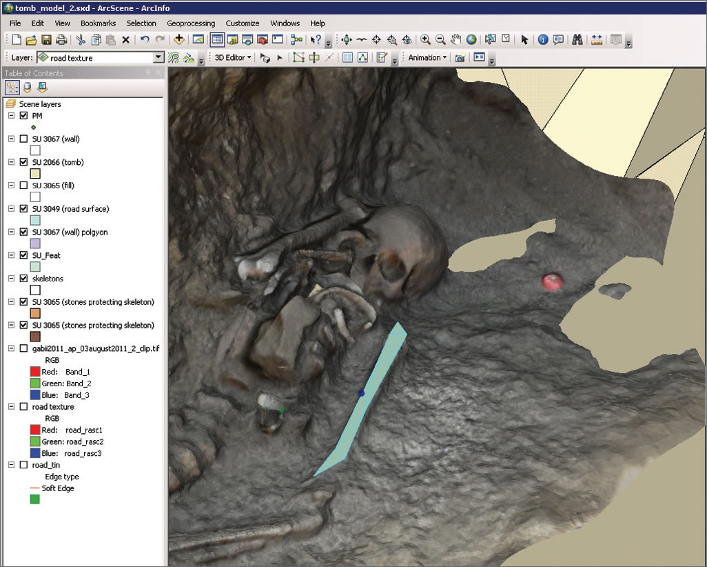
Using the 3D editing tools in ArcScene, polygons, polylines, and points representing individual features like a bone, pot, or stone can be digitized directly onto the model. These digitized features can then be used for simplified representations of the model, in the creation of 2D plans, or for spatial analyses in the GIS. Alternatively, this characterization could be carried out in the modeling software and imported and transformed in parallel with the model. Relationships between the models, digitized features, and descriptive attributes are maintained within the geodatabase.
Working with Mesh Data in a GIS Environment
Importing the models created through photogrammetric survey into a GIS makes it easy to understand at a glance the 3D relationships between features. Integrating these visually rich models with descriptive data and providing easy access to spatial analysis tools through the GIS supports analysis and interpretation after the field project has ended or when working in the lab. And, of course, 3D models make for compelling visualizations for use in teaching and publication, helping students, researchers, and the public explore and understand the archaeology.
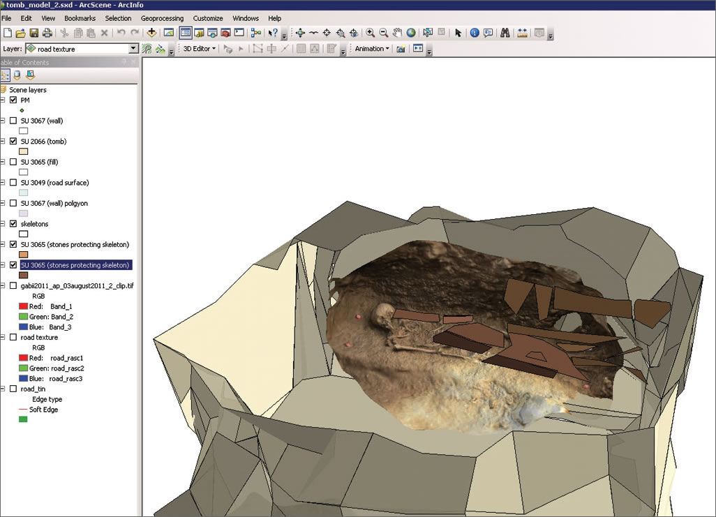
Mesh data can be viewed in combination with surveyed features. The skeleton, modeled using photogrammetric survey, can be seen with the slabs placed over it at the time of burial, modeled from survey data.
For more information, contact Rachel Opitz, Center for Advanced Spatial Technologies (CAST), University of Arkansas, at ropitz@cast.uark.edu.
Detailed workflows for bringing mesh data into ArcGIS can be found at the CAST GeoMetaVerse (gmv.cast.uark.edu).
More information about the Gabii Project can be found at sitemaker.umich.edu/gabiiproject/home. The Gabii Project is supported by a grant from the US National Endowment for the Humanities.
Acknowledgments
Special thanks to Soprintendenza Speciale per i Beni Archeologici di Roma (Dr. Anna Maria Moretti and Dr. Stefano Musco) for their ongoing support of the Gabii Project.
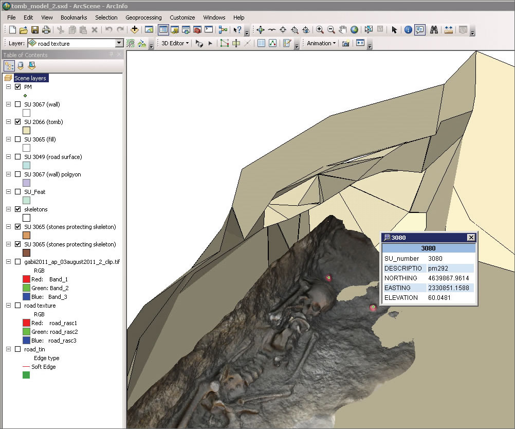
Metadata, like the model number and stratigraphic unit number, can be stored in related point and polygon feature classes.
About the Authors
Rachel Opitz received a doctorate in archaeology from the University of Cambridge in 2009. She works for the Center for Advanced Spatial Technologies at the University of Arkansas and leads the GIS and Survey team for the University of Michigan excavations at Gabii, Italy. Her research interests include landscape archaeology, GIS, and laser scanning.
Jessica Nowlin is a doctoral candidate at the Joukowsky Institute for Archaeology and the Ancient World at Brown University. Her research interests include landscape archaeology, the application of GIS and remote sensing, economy and trade, road networks and boundaries, public archaeology, and archaeological ethics. She leads the photogrammetric survey for the University of Michigan excavations at Gabii, Italy.