ArcUser
Spring 2012 Edition
Turning Analysis into Action
Targeting likely sources of watershed impairment
By Katy R. Beckham, Christine Boring, and Mark White, Research Planning, Inc.
This article as a PDF.
A science-technology consulting firm in South Carolina used spatial analysis to identify landowners whose land-use practices might be contributing to the impairment of water bodies in the Catawba River Basin. Once these landowners were identified, an outreach program would encourage participation in a cost share program that helps install environmentally sound wells, waterlines, creek exclusion fencing, and other facilities.
Protecting Water Quality
The South Carolina Department of Health and Environmental Control (SCDHEC) Bureau of Water, Division of Water Quality, in consultation with the US Environmental Protection Agency (EPA), administers grants for Nonpoint Source (NPS) Control Projects on impaired water bodies in South Carolina. Water bodies that do not meet water quality standards pursuant to section 303(d) of the Federal Clean Water Act are considered impaired.
EPA provides monies for these projects to SCDHEC under the Clean Water Act, section 319(h). Goals of the SCDHEC 319 program include reducing nonpoint source contributions to South Carolina's watersheds and implementing Total Maximum Daily Loads (TMDLs). Most TMDL implementation projects in South Carolina focus on implementing best management practices on livestock farms and mitigating failing septic systems. [Nonpoint sources are sources of pollution that lack a single point of origin or specific outlet to a stream and are generally carried off the land by storm water. According to the EPA, a TMDL "is the amount of a single pollutant (such as bacteria, nutrients, metals) that can enter a waterbody on a daily basis and still meet water quality standards set forth by the State."]
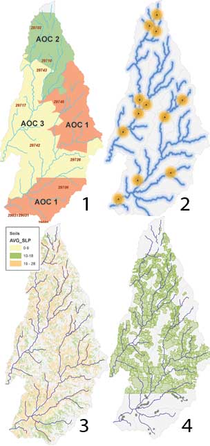
Steps in the analysis process included: (1) defining areas of concern by ZIP Code; (2) creating the water quality monoitoring station and hydro buffers; (3) performing slope analysis; and (4) identifying the hot spot parcels to target for participation in the cost-share program
Targeted Approach to Watershed Health
SCDHEC awarded a grant to Research Planning, Inc. (RPI), to implement a TMDL for fecal coliform bacteria in the Bullock and Turkey Creek Watersheds in the Catawba River Basin. RPI's responsibilities under this grant included identifying landowners (farmers and septic system owners) whose current land-use practices may be contributing to impairment of the water bodies; implementing environmentally sound watering structures, wells, waterlines, creek exclusion fencing, and other BMPs on agricultural lands; and repairing failing septic systems.
RPI would also perform community outreach to solicit additional participation either through grant monies, other federal programs, or on a volunteer basis to improve farm practices in the local watershed and beyond. SCDHEC requires detailed quarterly updates from all grantees to assess progress on the projects they manage as part of the 319 program.
Under past grants that SCDHEC had awarded to RPI, any improvement in watershed health was considered a success. However, during a kickoff meeting for the Turkey/Bullock Creek project, SCDHEC suggested that a more targeted approach for identifying potential participants (e.g., farmers) was the most attractive path forward.
Past efforts for identifying participant landowners were focused on community meetings and word of mouth. Restoring the full use of a water body is the goal of both the SCDHEC and EPA. Therefore, targeting improvements on lands most likely to impact water quality upstream of the sampling stations was desirable.
As an initial phase in the project and in an attempt to satisfy the need for a targeted approach, RPI suggested geospatial analysis as a method for identifying those agricultural lands that had the most impact on water quality within the watershed. The goal was to solicit participation in the 319 program by landowners whose lands greatly impact the area's hydrology. The 319 program offers two types of cost-share programs: programs for capital improvement for livestock producers that promote conservation and programs that help repair failing septic systems. Although RPI's analysis was twofold, this article focuses on programs for livestock producers.
Once a landowner is part of the program, monies are set aside to pay a percentage of the cost for implementing environmentally sound farm improvements that positively impact water quality in the watershed.
RPI initially reviewed previous studies of watershed impairment. Based on this review, RPI made a list of GIS layers that could be useful in this analysis and identified how they could be obtained. Hot spots of concern would be identified and used to focus cost-share efforts. These areas of concern (AOCs) were identified by creating a buffer and performing slope and parcel size analyses.
Establishing Areas of Concern
The AOCs were selected based on beef cattle production reported in the United States Department of Agriculture (USDA) 2002 Census of Agriculture, the most recent dataset available at the time of the analysis. This flat file, available at no charge, contains data on the number of beef farms, number of cattle, and other farm statistics. A spatial component was created based on ZIP Code data in the file. To obtain current estimates of beef cattle per ZIP Code within the study area, census data was joined to Esri's ZIP Code shapefile. Using the number of beef cattle, RPI ranked ZIP Codes within the watershed, with AOC 1 being an area with the highest number of beef cattle—areas that would show the most impact within the study area.
Buffers were created around both hydrological features and water quality monitoring stations (WQMS). Hydrological datasets obtained from Esri as part of the standard ArcGIS data package included streams of third order and higher. Hydrological datasets from local and state governments and other sources were considered, but they included smaller order streams that covered too much area, negating the desired targeted approach. Also, some of these datasets contained ephemeral and intermittent water bodies. A trial-and-error approach was used to determine the buffer sizes that best fit the analysis. Buffer sizes chosen for the analysis (given in miles) were 0.125, 0.25, and 0.50.
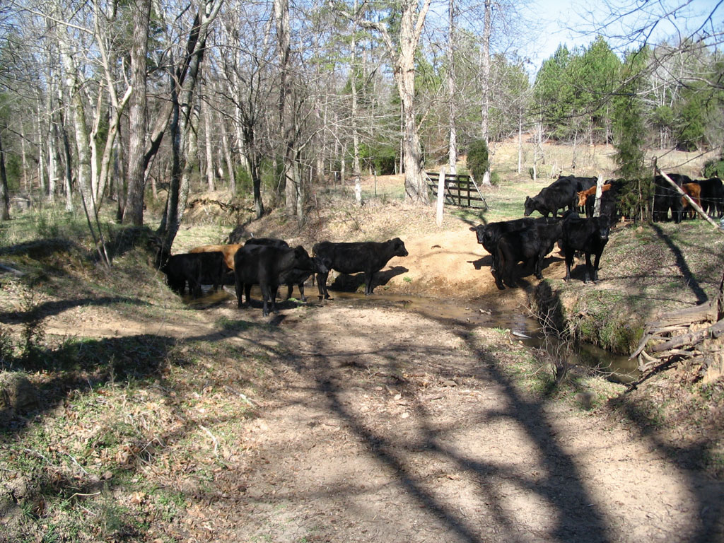
Cattle standing in stream before the cost-share program was implemented
WQMS data, obtained from the SCDHEC website at no charge, included only point features. Larger buffers were created for these points than for the hydrological features. Buffers chosen were 0.50, 0.75, and 1 mile.
Slope Analysis
The slope analysis was conducted on a merged soils dataset for the study area. This dataset was created from datasets obtained at no cost from the South Carolina Department of Natural Resources (SCDNR). To capture the entire study area, these datasets were merged together from multiple quadrangles and clipped to the study area. The dataset contained not only soils information but also slope data for each soil type. To highlight areas where runoff was more likely to occur, only areas with significant slope were needed for analysis. This was determined by calculating an average of the slopes in the area. Any slope number greater than that average was considered significant for purposes of this analysis.
Parcel Size Analysis
The parcel size analysis was conducted to select larger parcels that were more likely to be used for agricultural purposes. This was but one method in a multilayered analysis designed to identify tracts of land that could be impacting the watershed's hydrology. This analysis used a parcel dataset acquired from York County's GIS department and made available for free to government agencies. Also obtained from the same source were land-use and subdivision data.
The parcel dataset contained the owner name, owner address, parcel address, parcel size, and other attributes. The future land-use dataset was used in conjunction with the parcel size dataset because it is constantly being updated by the county government's GIS department to reflect zoning changes, as land use in this particular county trends toward nonagricultural functions. A dataset containing subdivisions was also used in the analysis.
Initially, parcel selections were made to remove subdivisions and nonagricultural parcels. Parcels having a centroid in a subdivision were removed to eliminate "minifarms" or houses with more acreage than typical for a subdivision. Using the Select By Location command in the subdivision and parcel datasets, analysts selected features that were exported to a new shapefile.
The future land-use dataset was queried to retrieve agricultural land-use parcels and exported to a new layer. This new parcel dataset, excluding subdivisions, was used to clip the new agricultural shapefile to yield only agricultural parcels and create a dataset showing parcels currently in agricultural land use that are not in subdivisions.
To ensure that analysis was limited to areas with potential large farm operations that are most likely to impact water quality, RPI determined (based on its experience working with these types of cost-share programs) that a large parcel is one of 250 acres or more.
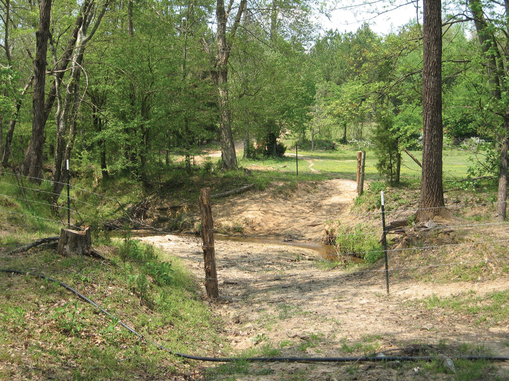
Cattle excluded from the water body through funding from the program
Hot Spot Selection
After all analyses were complete, the final datasets were layered to determine where the study hot spots were located. The hot spot analysis was designed to return only the areas in highest demand for cost-share participation with theoretically the most impact to the watershed.
Hot spot parcels were those that met at least one of the following criteria:
Parcels located within the hydrological features (0.5 mile) and/or water quality monitoring stations buffers (1 mile)
or
Parcels containing soils with a slope greater than 10 percent (i.e., greater than average in this area)
or
Parcels located in at least one buffer (either hydrological features or water quality monitoring stations) with a parcel size greater than 250 acres
All selections were exported to new shapefiles that were merged, dissolved by tax map ID number (to eliminate duplication of parcels that met more than one of the criteria), and attributed to reflect all the conditions. The parcel attribute information was joined back to the final parcel shapefiles to add information for soliciting participation in the program.
Results of Outreach
Direct mailings were made to landowners in hot spot areas identified using the parcel attribute information. Large wall maps were made showing hot spot areas and taken to local cattlemen meetings where farmers from the study area would be in attendance. Using this analysis, farms in hot spots were actively pursued. As of this writing, RPI has worked with nine agricultural landowners in the watershed to help remediate slightly less than 2,000 acres by installing approximately 12,000 feet of waterline, more than 20,000 feet of fencing, and seven wells. For more information, contact Katy R. Beckham.
About the Authors
Katy R. Beckham is a GIS analyst and biologist for Research Planning, Inc. She focuses on GIS mapping for oil spill response, water quality improvement/watershed management, and other ecological projects. Beckham holds a bachelor's degree in aquaculture, fisheries, and wildlife biology and a master's degree in forestry and natural resources, both from Clemson University in Clemson, South Carolina.
Christine Boring is an ecologist for Research Planning, Inc., specializing in coastal ecology, natural resource mapping, and water quality improvement/watershed management. Boring holds a bachelor's degree in biology from the University of Michigan and a master's degree in ecology and evolution from Rutgers University in New Brunswick, New Jersey.
Mark White is the GIS manager and senior analyst for Research Planning, Inc. He focuses on project and personnel management for natural resource mapping projects, emergency response data management, and damage assessment. White specializes in geospatial analysis, database design and management, remote sensing, and new project development. He holds a bachelor's degree in geography from the University of South Carolina in Columbia, and a GIS professional (GISP) certification from the GIS Certification Institute (GISCI).
Resources
United States Department of Agriculture (USDA) Census of Agriculture dataset