Dealing With Risk Spatially
The Federal Emergency Management Agency (FEMA) provides integrated mapping for decision makers and communicates effectively with the public with the help of GIS. This independent federal agency is tasked with reducing the loss of lives, property, and infrastructure from all types of hazards through the assessment, identification, reduction, and communication of risks and the administration of risk insurance.
 |
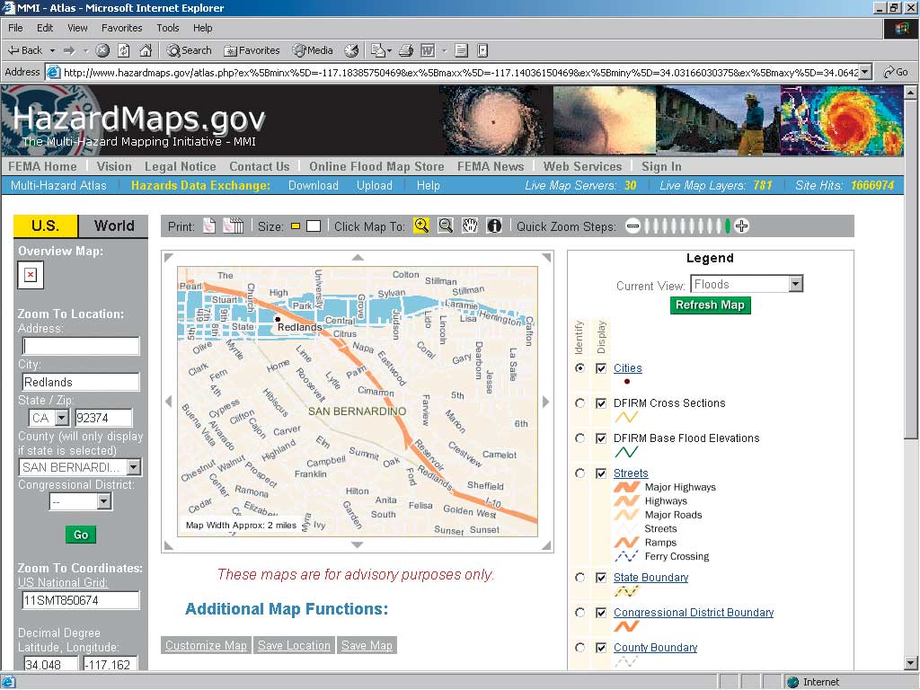
| Multihazard mapping is available to the public online at HazardMaps.gov, an interactive atlas that features 30 map servers and 781 live map layers. |
Through the Multi-Hazard Flood Map Modernization Program, FEMA is updating and converting the paper flood hazard maps to Digital Flood Insurance Rate Maps (DFIRMS) in a GIS format that will enable all hazard mapping for planning and risk management. FEMA's Cooperating Technical Partners Program works with National Flood Insurance Program communities to keep flood maps up-to-date and enable this data to be leveraged through integration with statewide GIS systems. For additional information on the Multi-Hazard Flood Map Modernization Program, see "A New Generation of Flood Management" in the October–December 2002 issue of ArcUser magazine.
The agency has developed tools for decision makers that include HAZUS-MH, a powerful risk assessment software program that uses GIS to analyze potential losses from floods, hurricane winds, and earthquakes.
Estimating losses caused by a natural disaster is the basis for mitigation assessments, emergency preparedness plans, and response and recovery coordination. GIS combines hazard layers with national datasets of demographics, building inventories, transportation networks, and utilities. Developed by FEMA's Mitigation Division under contract with the National Institute of Building Sciences (NIBS), this software incorporates NIBS research into the effects of hurricane winds, floods, and earthquakes on structures.
HAZUS-MH not only estimates physical damage but also projects economic loss from lost jobs, business interruptions, and reconstruction costs and social impacts relating to requirements for shelter and medical aid. It is available to government agencies and the private sector free of charge.
Multihazard mapping is also available to the public online at HazardMaps.gov. This interactive atlas, developed in partnership with the National Oceanic and Atmospheric Administration, features 30 map servers and 781 live map layers. The data is furnished by a network of hazard and basemap providers. The site promotes data interoperability and the exchange of geospatial hazards data.
In addition to risk identification and communication, FEMA uses GIS in its disaster response activities. The efforts of hundreds of volunteers searching for debris from Space Shuttle Columbia were guided and coordinated by FEMA with the help of GIS. The shuttle exploded on February 1, 2003, showering shuttle parts—from tiny particles to sizable chunks—over a swath of Texas three counties wide. FEMA headed the interagency GIS team that supported the recovery effort using Microsoft SQL Server and ArcSDE to warehouse the gathered data and allow authorized users to access datasets from remote locations.
In many ways, the shuttle recovery is representative of the cooperative nature of FEMA operations. FEMA works with the 26 other member agencies of the Federal Response Plan as well as volunteer organizations, emergency planners, and state and local government officials. The agency's mapping efforts support the Department of the Interior's Geospatial One-Stop and the United States Geological Survey's National Map and are part of a larger goal of sharing data to limit cost. FEMA's GIS activities help the agency mitigate the effects of hazards—both natural and man-made—by supporting better decision making and improving public risk awareness.
|