July - September 2002
July - September 2002 |
||||||||
|
|
||||||||
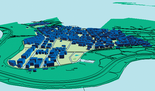
Current, accurate information assists decision makers in normal planning and monitoring tasks. For emergency planning and response, this type of dynamic information is even more important. The information gathered during the hours, days, months, and years following a disaster can lead to improved policies and practices that reduce risks and enhance the effectiveness of emergency planning, awareness, preparedness, and recovery. Earthquakes, one of the oldest enemies of mankind, can now be mapped and analyzed. GIS helps national, regional, and local emergency organizations plan and manage preparedness programs. Urban information systems, a subspecialty of GIS, are used to analyze the location of both populations and infrastructure. This article, describing an earthquake-preparedness study of a district in stanbul, Turkey, illustrates how the effects of earthquakes can be minimized, emergency response planned, and an urban inventory created using GIS. Pendik, an administrative district located in eastern stanbul, has a population of 389,000 and stands at the gateway to stanbul. Important highways pass through the district, and one of stanbul's two airports is located there. As a result, many leading companies have located in Pendik. Its strategic location has caused rapid population growth. The resulting population pressure has contributed to the lack of planned development in the district. GIS has proved a powerful tool for assessing the risk and prioritizing needs in Pendik. ArcView, versions 3.2 and 8.1, were used to produce detailed risk maps, perform queries, and generate analytical reports. After collecting the municipal data describing the district's land, residents, and infrastructure, digitizing and editing were done using Esri products.
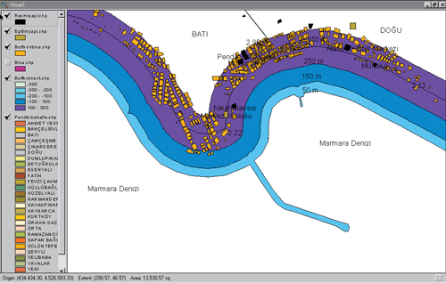
A database structure was created and table links and joins were created to make data kept in Microsoft Excel accessible to ArcView. Some of this data was also kept in Microsoft Access files and ArcView attribute tables. After preparations were completed, thematic maps could be created for the Pendik Urban Inventory. Data for hospitals and health centers, schools, governmental buildings, police and fire stations, industrial buildings, and gas stations was created as separate themes. Geological maps and infrastructure maps were produced. Chart maps produced in ArcView were used to make comparisons between neighborhoods and identify areas where earthquake preparedness could be improved. One neighborhood was selected for a pilot study. Using information gathered during a field study of this neighborhood, thematic maps were built by querying the database. Information on area housing, which included the occupancy type for the ground floor and other floors as well as number of stories, construction type, and the number of flats in the apartments, was shown in different views. Mapping and spatial analysis have helped authorities make better decisions and formulate more effective policies for local emergency bureaus. Working with geographic data can answer questions such as "where is...?", "what intersects...?", and "what if...?" Analyzing the location of various structures in relation to hazardous conditions highlighted significant dangers. Querying the building theme to find all buildings located on earthquake faults identified 255 such buildings. Many residential buildings and industrial plants are located on alluvial ground. [Loose soils amplify and prolong shaking.] Thirteen schools are located on unstable land. Potentially explosive natural gas main pipes and tanks as well as 56 companies that produce hazardous materials and 76 gas stations are located on unstable land. Several unauthorized buildings are located under high voltage power lines. GIS was also used for other emergency preparedness activities.
Conclusion
Urban information systems help automate analysis, share information, and encourage teamwork. By visually displaying information, GIS enhances risk evaluation and performs analyses that would not otherwise be possible. Real-time information updates in GIS support better decision making and improve earthquake management. Creating an urban inventory, thematic maps, and queries also helped identify Pendik's most vulnerable areas and "what-if" scenarios helped in planning mitigation measures such as retrofitting and relocation. Esri products have helped develop new applications to support emergency preparedness. GIS technology manages vast quantities of information quickly in an emergency and helps authorities formulate strategies that mitigate the effects of future earthquakes. For more information, contact: Ozge Yalciner, Urban Planner and GIS Specialist |