July - September 2002
July - September 2002 |
||||||||
|
|
||||||||
California's pesticide regulatory program is considered by many to be a model program, and its pesticide use reporting program is recognized as the most comprehensive in the world. In 1990, California became the first state to require full reporting of agricultural pesticide use. Under the program, all agricultural pesticide use must be reported monthly to the county agricultural commissioner who in turn reports the data to the Department of Pesticide Regulation (DPR). The reports must include the date and location (section, township, and range) where the application was made and detail the kind and amount of pesticides used. If the pesticide is applied to a crop, the type of commodity must be specified. In recent years, the California Department of Pesticide Regulation has taken a number of steps to improve the use reporting system including working to standardize site identification. A Permit Mapping Assistance Program was established in 1995 to encourage the development and use of GIS to more accurately identify agricultural fields where pesticides are applied. DPR has worked closely with the county agricultural commissioners to provide leadership and support in implementing GIS technology in their business programs; develop standards that address issues of State-wide consistency; improve quality and timeliness of reported pesticide use data; and develop and provide GIS tools to assist in the collection, evaluation, and maintenance of restricted materials permits and pesticide use reports.
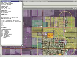
The use of GIS by county agricultural commissioners has grown considerably since the inception of the Permit Mapping Assistance Program, from less than a handful of counties to more than 25. The development of field border databases and parcel boundaries for permitted agricultural field sites has been identified as the most important spatial data component required to adequately manage State-wide pesticide use. Improving the spatial resolution of pesticide applications from the current square-mile section to an actual field site has been shown to significantly improve government's ability to responsibly regulate pesticide use and thereby enhance the protection of California's citizens. Counties from the San Joaquin and Sacramento valleys, California coastal region, Sierra foothills, and San Diego-Imperial area are using GIS to develop field border databases. All are beginning to realize enhanced decision making abilities that can be leveraged by gathering spatially accurate information. GIS programs in two California counties have utilized Esri's desktop technology in unique and exciting ways. In Kern County, staff biologists and local growers work together in a customized ArcView 3.2 environment to identify crop sites and assess those sites for proximity to sensitive areas, such as schools, residential areas, or farm labor camps, for each of the 1,200 permits issued and 13,000 sites analyzed annually. The tabular data for the existing pesticide permitting program is a rich source of information for the GIS permitting process. The program is built on a Dataflex database accessible to ArcView only through a proprietary Open Database Connectivity (ODBC) driver. All tasks are carried out from a single view. The interface has been redesigned with new menus, buttons, tools, and pop-ups. The table of contents is invisible to the user and the program makes extensive use of ArcView legends to emphasize different features during the permitting process. The entire operation is directed from start to finish. Extensive error trapping is built into the process. All code is written in Avenue. The permitting program runs on a Windows 2000 Server with Terminal Services activated and Citrix XPe controlling user access. Each desktop in the department is equipped with a MaxSpeed thin client, and every individual who works in the permitting program has his or her own ArcView project. Each project is customized so multiple users can edit and create data simultaneously in the program. In Glenn County, an application is being developed that will allow biologists to create and maintain the spatial database using a program that utilizes the Esri MapObjects map control object together with an ODBC driver that connects to the pesticide database. Users select a grower's name from the drop-down list box, and the map control object is then updated with the grower's fields. When a site is selected in the Fields box, the corresponding agricultural field is highlighted in the map. To assign attribute information to an agricultural field, the user simply drags a site from the Fields box and drops it onto the field on the map. Users can also create a new field using the pointer to draw a polygon around the field and then update its attributes by clicking and dragging the information from the Fields box.
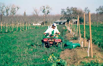
DPR recognizes that the county agricultural commissioners are responsible for a large part of the work in creating and maintaining the pesticide use database and its GIS component. Local involvement is key to the success of the program. DPR plans to reengineer and upgrade the current pesticide use reporting system. This update will include incorporating a GIS component into the statewide permitting program. Until this happens, DPR will continue to coordinate the efforts of the county agricultural commissioners and provide leadership, continuity, and technical support in the collective effort to map California's permitted agricultural lands. AcknowledgmentsThe author acknowledges the contributions of Mark Sabin, agricultural biologist at the Kern County Department of Agriculture, and Patrick Way of The Way Company to this article. Sabin developed the KGIS application for the Kern County Department of Agriculture. Pat Way is developing the Glenn County Agricultural GIS for the Glenn County Department of Agriculture. The author also thanks Glenn County Agricultural Commissioner Ed Romano and Kern County Agricultural Commissioner Ted Davis and Jean Miller of Glenn County for providing the photograph. ReferencesPesticide Use Reporting: An Overview of California's Unique Full Reporting System, California Department of Pesticide Regulation, Sacramento, California. May 2000. www.cdpr.ca.gov/docs/pur/purovrvw/tabofcon.htm About the AuthorRosemary Neal is a research analyst in the Pest Management and Licensing Branch of the California Department of Pesticide Regulation (DPR). She has been with DPR since 1988, and her expertise includes a doctorate in soil chemistry and 10 years experience using GIS. Her primary responsibility is coordinating DPR and the California County Agricultural Commissioners' efforts to develop a GIS component of California's Restricted Material Permit and Pesticide Use Reporting programs. She has spent the last seven years providing leadership in the development of agricultural site identification recommendations and standards, field boundary shapefile standards, and GIS support and programming expertise to County Agricultural Commissioners. Her technical skills include extensive use of Avenue for developing specific ArcView functionality and customization. |