Imagery for the Rest of Us
By Richard Schulman, Resource Strategies Inc.
GIS is undergoing rapid change. Dramatic improvements in sensor technology, computational speed, and processing algorithms have spurred dramatic growth in the availability and interest in this data type. The competitive remote sensing marketplace, both commercial and government-sponsored, has been responsible for the production and sale of affordable, high-resolution, worldwide datasets.
GIS evolved as a vector-based system. Initially ArcInfo worked with points, lines, and polygons. Today, the ability to use information-rich raster image data is available as part of core GIS products and additional functionality is available through the use of extensions. The recent proliferation of current imagery coupled with advanced compression technologies means even gigabyte images can be loaded and rapidly displayed. In a similar fashion, the availability of high-resolution elevation data provides users with the opportunity to add a meaningful third dimension to GIS applications.
This is a very exciting time for those involved in GIS. The recent launch and successful operation of three commercial high-resolution satellites and the rapidly expanding fleet of both digital and analog aircraft-borne aerial imagery systems means that GIS users throughout the world can benefit from having an "eye in the sky." However, with this abundance of image data comes a note of caution for the seasoned data specialist as well as the novice--before embarking on a major data acquisition project, be sure to understand the myriad of data selection options available and test sample data.
There are two categories of issues that must be considered when using imagery data--determination of technical and managerial goals for the project and identification of the project's specific dataset requirements and tradeoffs.
Considering Technical and Managerial Goals
Technical project goals can be as specific as identifying new streets and roads, locating obstacles to a future right-of-way, or locating a particular plant species or broader goals such as monitoring crop health or detecting changes in urban growth patterns. Beyond these technical goals, find out what managerial goals exist for the project. What does management hope to accomplish with the imagery and the associated spatial data? Answering the following questions will help uncover the project's overall objectives.
- Who will use or view the data? Will it be management, the public, casual GIS users, or GIS experts?
- How often must the data be updated?
- How much of the budget is available for data acquisition?
- How large an area must be captured?
- How often and what type of information will be gleaned from the imagery and associated data (e.g., elevation, parcel boundaries)?
Dataset Requirements and Tradeoffs
Determining requirements and deciding appropriate tradeoffs is an aspect of data acquisition that often calls for outside assistance. This assistance can come from a knowledgeable data reseller, a consultant specializing in using remotely-sensed data, or perhaps even another GIS user who has extensive experience with image data. Because the remote sensing field is changing rapidly and its jargon is obscure to the novice, the best options for meeting a project's goals and objectives may not be obvious at first.
While the imagery options are relatively few, the matrix of potential combinations is extensive. The factors to consider when choosing image data include
- Intended use/application
- Image resolution
- Spectral bandwidth and range
- Acquisition date and update requirements
- Radiometric and geometric corrections
- Location
- System and standards considerations
- Budgetary considerations
Intended Use/Applications
Often the intended use will drive the selection of many of the other key options. For example, a crop assessment project will most likely require three bands of multispectral data. A municipal inventory of manholes and fire hydrants demands imagery of the highest possible spatial resolution. Data currency would be the most important consideration for an urban growth application while a real estate development or water pipeline project might place the most value on elevation or topological data.
Spatial Resolution
For both satellite and aerial imagery, resolution is often the first parameter for categorizing the data. Resolution refers to the smallest viewable picture element (i.e., pixels) captured by the satellite (or aerial) sensor. Therefore, a five-meter satellite image has pixels that represent an area five meters by five meters on the ground. The highest resolution commercial satellites now aloft and operational carry two-foot sensors. At this resolution automobiles, boats, homes, trees, roads, and trails are easily detected. Aerial imagery can be flown and processed at resolution of three inches per pixel.
Spectral Content
The spectral range and number of bands is the second key parameter for categorizing sensors and the resulting imagery. Satellites often carry more than one sensor producing images that can be either panchromatic or multispectral. Airborne sensors fall into two general classes--traditional film cameras loaded with either panchromatic, true color, or infrared film and newer digital cameras that can acquire imagery with either three or four bands with some combination of red, green, blue, and infrared. Film negatives or positives are typically scanned, processed, and stored as digital files. Broad bands tend to have higher resolution than narrow multiband sensors. Some satellites and airborne systems employ radar or other techniques that capture images at frequencies outside the visible or infrared portion of the spectrum.
Platform Considerations
Once the goals, objectives, key options, and considerations have been addressed, selecting the acquisition platform and specific data offer is relatively straightforward. With regard to acquisition platforms, in general satellites have the advantage of being able to acquire current data on a worldwide basis, limited only by potential cloud cover, priority of sensor availability, processing time, and minimum purchase requirements. Aerial imagery is typically lower in cost and less frequently updated. For many cities, low-cost data of high quality is often available "off the shelf," particularly in the United States and Europe. However satellite archival imagery, perhaps at lower resolution, may be readily available for virtually the entire planet.
Currency and Update
Is current imagery required? If not, archived images may be available for the area of interest. Older imagery can often be provided at substantially lower cost as compared with requested current or future (i.e., advance order) collection. Fortunately most of the newer satellites have onboard storage capabilities so images can be collected almost anywhere on earth and transmitted to the next appropriate ground station.
Commercial satellite revisit time for any specific location on earth ranges from three days to every other week. Aerial imagery may be collected either on a contract or custom basis or may be available from annual "speculation" flights by aerial companies covering major urban areas and, selectively, entire counties in some regions of the United States. Some applications that perform change detection for land use, land cover, environmental analysis and meaningful forecasts for planning purposes require co-registered imagery from different dates.
Horizontal Accuracy and Orthoimagery
Imagery without an accurate ground basis is just a pretty picture. Consequently, horizontal accuracy specification is another key parameter of imagery. Whether the resolution is five meters or one foot, the offset of each pixel to "real ground truth" may be critical to a GIS, CAD, or remote-sensing project. The United States Geological Survey (USGS) has published quadrangle maps for the entire country with a specification of horizontal accuracy. The accuracy standard states that any location on the map will be within x meters of the true geographic position 90 percent of the time (i.e., x meters with circular error 90 percent). Similarly horizontal accuracy for satellite and aerial imagery is often specified. For example, horizontal accuracy rating of "10 feet CE90" means 90 percent of the pixels, selected on a random basis, will fall within 10 feet of the real earth position.
The user must understand that when most imagery is collected, it reflects only the horizontal distribution of pixels based on the camera or sensor optics and other aspects of the imagery collection system. Before post processing, imagery may be distorted relative to ground truth. Essentially, there are two ways to correct this distortion--"rubber sheeting" and true rectification or orthorectification.
The rubber sheeting process produces a roughly geopositioned image by stretching or shrinking the image to match control points on a known raster source such as a USGS digital quad or an accurate vector file. The resulting image will lack uniform horizontal accuracy across the image and is not geometrically precise.
Typically, orthorectification processes correct for terrain or elevation distortion and properly project the horizontal pixels into the correct relative locations. In order to properly represent this redistribution of pixels relative to the earth's "true" geometry, a standard projection is used. Although latitude/longitude (i.e., geographic coordinates) can be used to represent any place on earth, specific coordinate systems are more useful for particular mapping applications. The coordinate system used typically relates to the size of the area being considered. To represent a relatively small area such as the City of San Diego or San Diego County in California, the appropriate State Plane Coordinate System (California State Plane, Zone 6) might be used. Perhaps the best known global-level coordinate system is Universal Transverse Mercator Projection (UTM). It divides the earth into 60 zones of six degrees each and uses a numbering system that designates northern or southern hemisphere for each zone.
Data Compatibility and Integration
A serious consideration for any project is data compatibility. Using current GIS and remote sensing processing software, it is relatively easy to import combinations of vector, raster, and point data and any associated attribute data. The tough part is combining datasets with dissimilar projections, pixel resolutions, and ground levels of accuracy. One of the many challenges GIS and remote sensing specialists face is to minimize or mitigate the impact of data incompatibility by thoughtfully considering these issues and developing appropriate data management strategies. Careful selection of the basemap reference layer, data projection, image accuracy, and radiometric precision are critical elements for a successful imagery project.
Conclusion
Imagery options are robust and plentiful. Organizations and individuals worldwide have the opportunity to see their world in more detail than ever before. Imagery and associated data is readily available, rich in content, and becoming more affordable for a rapidly expanding user base worldwide. Remote sensing data--no longer confined to a few specialized organizations--is readily available to everyone, anywhere, and any time.
For more information, contact
Richard Schulman
Resource Strategies Inc.
4770 Clairemont Mesa Blvd.
San Diego, California 92117
Tel.: 858-581-6682
E-mail: resourcestrategies@usa.net
About the Author
Richard D. Schulman is an experienced data broker serving water districts; state, county, and local government agencies; tribal nations; and commercial firms. Schulman, a pioneer of the computer industry for 40 years, founded Resource Strategies Inc. in San Diego in 1985. The firm specializes in satellite and aerial imagery, elevation data, and related GIS and remote sensing applications.

Photo courtesy of AirPhotoUSA, Phoenix, Arizona
Fire Prevention
| DON'T HAVE--Remote2B_Acapulco.jpg |
| Photo courtesy of Space Imaging, Thornton, Colorado |
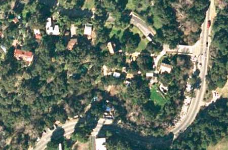
Los Angeles County Fire Department is using high-resolution, two-foot/pixel color aerial imagery for fire risk assessment and simulation modeling to prepare for the high-risk fire season expected in summer 2002 in Topanga Canyon area of west Los Angeles County.
DON'T HAVE--Remote2A_MO.jpg
Photo courtesy of Space Imaging, Thornton, Colorado
International/Travel/Hospitality
Montego Bay, Jamaica, resort area (top photo) and Acapulco Bay, Mexico (bottom Photo) are captured with pan sharpened natural color IKONOS satellite imagery at one meter/pixel.
 |
| Photo courtesy of Space Imaging, Thornton, Colorado |
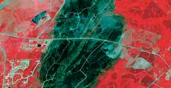
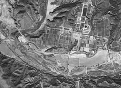
Fire Damage Assessment
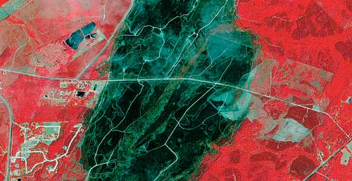
Wildland fire in Georgia shown in this false color (infrared) IKONOS satellite imagery (four meters/pixels), which provides a clear overview of fire extents. Red indicates healthy vegetation/tree cover, green represents burnt or burning areas. Note that the white areas indicate smoke rising from numerous hot spots.
 |
| Photo courtesy of Aerial Access, San Diego, California |
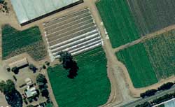
Agriculture
An herb farm in San Diego County, shown in one-foot/pixel natural color aerial imagery that shows municipal land use and crop health.
Environmental
 |
| Photo courtesy of Space Imaging, Thornton, Colorado |
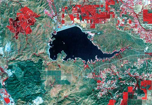
The Center for Natural Lands Management at the Lake Mathews Reserve in Southern California uses panchromatic five-meter Indian Remote Sensing (IRS) satellite imagery combined with infrared and color bands from the Landsat multispectral satellite. The false color imagery and change detection techniques facilitate tracking of patterns of vegetation growth and evaluation of management strategies for controlling exotic nonnative grasses versus native sage scrub. Lake Mathews is owned by the Metropolitan Water District of Southern California.
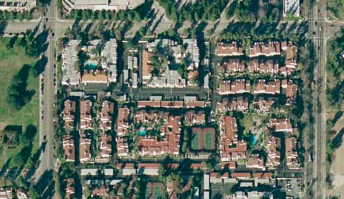
Real Estate Development
 |
| Photo courtesy of ISTAR Americas, Herndon, Virginia |
This image shows open space in Orange County, California, that is slated for development. The one-meter aerial panchromatic imagery shown has a horizontal accuracy of one meter and is matched with a contemporaneous digital surface model, which permits generation of both static and dynamic "fly thru" of the entire area as well as building and earth surface elevation data.
Regional, County, and Municipal Planning/Public Works
 |
| Photo courtesy of AirPhotoUSA, Phoenix, Arizona |
Annual wide area coverage of major metropolitan areas as well as entire county coverage in selected regions provides two-foot/pixel color aerial imagery for areas of high growth as well as established communities.
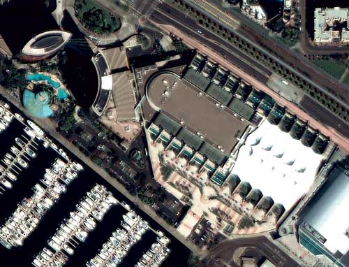
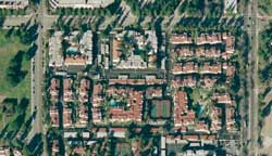
Esri International User Conference, San Diego
 |
| Photo courtesy of Digital Globe, Longmont, Colorado |
This image was captured by QuickBird, the world's highest resolution, commercial imaging satellite. The San Diego Convention Center, the primary site for the 22nd Annual Esri International User Conference, is shown in the center of the image with the Marriott Resort and its outdoor pool visible in the upper left.
Continued on page 2
|