July - September 2003
July - September 2003 |
||||||||
|
|
||||||||
Southern California has a unique wildland fire environment owing to its Mediterranean climate, highly combustible brush, frequent interface zones, and the complexity of its terrain. The term Initial Attack describes the resources that respond to the first phases of a wildland fire incident. Initial Attack engines, bulldozers, helicopters, and hand crews are dispatched to events that are chaotic and rapidly changing. Quickly spreading wildland fires often do the majority of their total damage in the first few hours. The Incident Commander (IC) makes critical decisions about the allocation of resources, incident strategy, and tactics based on his or her awareness or understanding of the situation. GIS can provide the IC with additional situational awareness by collecting and displaying timely and relevant information about topography, fuels, political boundaries, resource locations, fire perimeter, and assets at risk. Initial Attack GIS, a relatively new concept, was originally coined by the Ventura County Fire Department several years ago. Since then, Initial Attack GIS has gained acceptance and popularity among neighboring fire agencies in Southern California. Recently, both the Los Angeles County and Kern County Fire Departments have implemented Initial Attack GIS. The 2002 fire season gave the Los Angeles County Fire Department (LACFD) plenty of opportunities to prove the usefulness of having GIS technical specialists respond to the first stages of a wildfire. Last year, LACFD GIS teams responded as an initial attack resource to more than 20 wildland fires and an extended attack resource to a dozen more. How It's DoneThe goal of the LACFD GIS teams is to produce a working incident map within 45 minutes of arrival. Having a map with the current fire perimeter within the first hour of a wildfire can prove invaluable to the IC and initial attack resources. A map of the fire improves firefighter safety by giving the firefighters a visual tool that can be referenced when predicting fire behavior and identifying safety zones. By showing important geographic features that may delineate division breaks, a map can display where fire fighting resources are assigned.
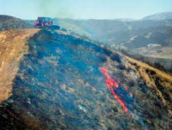
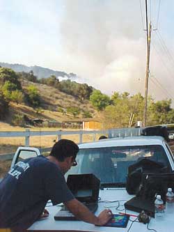
How is a fire perimeter obtained when the fire is still raging out of control? Only a couple methods can get this information in a timely manner. Most of the time, walking the fire line with a GPS unit is too dangerous. Flying the perimeter in a helicopter equipped with a GPS or mapping by hand from the air at a safe distance are two options. Although these options are preferable, often neither is feasible. During the initial stages of a wildland fire, helicopters are usually busy dropping water, which is a more critical task at that stage. LACFD has bulldozers with built-in GPS units made by TRUCKBASE. The GPS receivers in these bulldozers have a removable PC Type II card that can be processed using the TRUCKBASE software, and data can be exported as shapefiles. This system has proven to be extremely valuable because it takes the guesswork out of where a bulldozer line exists. However, this bulldozer line typically makes up only a part of the fire line. The rest of the fire has to be mapped using some other method. Mapping by hand or heads-up digitizing from a good vantage point allows a GIS technical specialist to map the fire and see the surrounding terrain. Although this option is not the most accurate or desirable, it is currently the safest, most effective, and quickest method for getting a decent map into the hands of firefighters. ArcPad installed on a PDA is a perfect tool for heads-up digitizing, often one of the only options available in the first few hours of an out-of-control fire. Using ArcPad, a GIS technical specialist can directly digitize the fire perimeter and bring that data into ArcView 3. Once in ArcView 3, the Ventura tools extension, developed by the Ventura County Fire Department, can be used to place appropriate fire symbologies and line types on the map and calculate acreages and distances. This map is printed in the field at the incident and handed out to fire fighting personnel as they arrive. Dealing With Jurisdictional BoundariesAnother critical task of the Initial Attack GIS team is to answer the question, "Is the fire near or on State Responsibility Areas (SRA) land or federal land?" SRAs are areas within the state of California for which the California Department of Forestry and Fire Protection (CDF) has primary responsibility for wildland fire and natural resource protection. Wildland fires in SRA lands can trigger dispatch of initial attack CDF resources and equipment through contract agreements between the state of California and local fire agencies. These types of agreements have also been established between federal agencies and local fire agencies. Often, GIS technical specialists can determine if the fire is on or near SRA or federal lands while en route to the wildfire incident by obtaining latitude and longitude for the fire and locating this position on data layers showing SRA and federal jurisdictions. Continued on page 2 |