Modernizing Land Records Pays Off
Editor's note: The GIS staff in Chester County realized that property addresses were used and needed by nearly every government computer application. The large number of users needing current and accurate address data opened up economies of scale for the county and, with increased use of this data by many departments, the potential for more rapid updates of it. By starting with E-911 applications, the most unforgiving applications that use address data, the county ensured that address data would be highly accurate. The county found that mapping addresses using GIS provided the best quality control mechanism for verifying address accuracy.
In 1988, the Commonwealth of Pennsylvania passed legislation that provided for a permanent referencing system for land records. Referred to as the Uniform Parcel Identification (UPI) Act, this bill allowed local governments to implement a UPI verification program that would
- Use the UPI number as a permanent referencing key to relate tax maps and legal descriptions.
- Cross-reference UPI numbers with relevant maps and eventually use UPI numbers in place of full legal descriptions on deeds and other legal documents.
- Make the county a repository for related maps and UPI numbers.
- Establish a fee to cover the cost of handling services under this act.
- After a four-year period, use UPI numbers to index documents.
- Require that any subsequent changes in parcel dimensions or descriptions must also include a full legal description that relates the parcel to the new UPI number.
One of the fastest growing counties in the Commonwealth, Chester County is approximately 750 square miles in size, has a population of 440,000, and contains approximately 180,000 parcels. Chester County used this legislation as the cornerstone of its land record modernization program, which was effected in conjunction with its GIS implementation efforts.
Starting With 9ll Integration
The county began its GIS implementation efforts in the early 1990s with a major step toward GIS/911 integration. The county's GIS staff maintains the geofiles used by a computer-aided dispatch (CAD) system and works closely with local telecommunications companies in maintaining address information used in emergency response. This work includes preparing master street addressing guide (MSAG) files that supply the basic geography used for dispatching police, fire, and emergency medical units.
 |
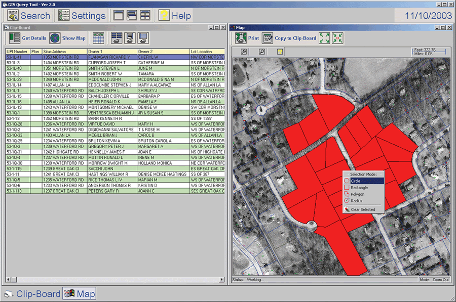
| Chester County found that mapping addresses using GIS provided the best quality control mechanism for verifying address accuracy. |
The E in E-911 refers to "enhanced." Enhanced 911 services use Automatic Number Identification (ANI) to determine the caller's telephone number and Automatic Location Identification (ALI) to supply the phone's location. This information speeds assistance to the caller. The county works with telecommunications companies in editing ANI/ALI files as well as updating Customer Emergency Service Number Assignment (CESNA) data.
The address base of the GIS is predicated on 911 address requirements. These addresses are known as situs or location addresses to differentiate them from mailing addresses. A key integration requirement for Chester County's GIS has been accurate cross-referencing between parcel addresses, parcel map polygons, and parcel identification numbers (PINs). PINs are used by both the Assessment Department and in GIS for map and record identification. Prior to adopting the UPI number, the county used six different PIN formats.
After considering alternatives, the county adopted the UPI number as the standardized key for accessing all land records. The county's GIS is now regarded as the repository for all address ranges, exact addresses, and related geofile information. GIS has become the glue that provides critical cross references of PINs, UPIs, map features, and situs addresses.
With the success of the county's 911/GIS integration and the UPI Act, the county set out to modernize its land records within a solid GIS framework. The county wanted to implement the UPI program without increasing the county's staff while providing additional automation for the county and private title insurance companies. The county wanted to enhance work flow efficiencies without unduly burdening title companies with daily recording activities. This could be accomplished by cross referencing key entities to each other and the maps. Traditional grantor/grantee or name indexes have been replaced by situs addresses as the most frequently used key to access deed book and page references.
Lessons Learned
Key lessons were learned from a pilot study for implementing the UPI program. Easy-to-use automation that included GIS mapping and digital orthophotographs for helping staff identify the correct property to record was necessary. Key staff members needed to work directly with Recorder of Deeds staff to provide fast turnaround and adequately support the title companies implementation would progress smoothly. A successful program could generate significant revenue without generating complaints.
 |
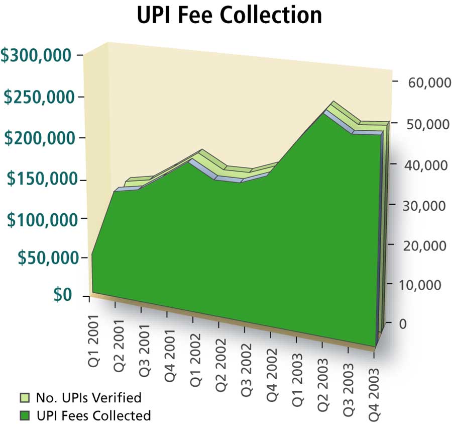
| UPI revenues by quarter since the inception of the program |
Tightly coupled automation was built using ArcInfo 7.x, ArcView 3, ArcGIS 8.x, and
Oracle's Web tools using 8i and Esri's MapObjects for map and photo display using multiple keys. The Recorder of Deeds system data resides in an Oracle database. Similar integration has been developed with the Assessment Office's system using Oracle and SQL*Forms. GIS provides the framework for integrating the commercial off-the-shelf (COTS) software for both the Recorder of Deeds and Assessment department. GIS is responsible for all key cross references.
Within the GIS department, the Bureau of Land Records (BLR) was tasked with implementing the UPI program. Three staff members work full time verifying the UPI numbers prior to recording them. Four other GIS staff work on deed research, mapping, and new parcel/record creation. All UPI numbers are verified prior to being recorded by the Recorder of Deeds. The UPI number is also used as an index key for the Recorder's documents. Verification of UPI numbers within 24 hours, 98 percent of the time, is the goal. BLR staff working closely with Recorder of Deeds staff provide significant expertise in the review of the legal descriptions and use of the GIS maps that complete the recording.
The implementation of the UPI program coupled with record low interest rates on home mortgages has led to significant revenues for the county. Since February 2001, the program has verified more than 400,000 UPI numbers, which resulted in revenues exceeding $2 million. In 2003 alone, $963,000 in UPI fees were collected.
In 2003—for the first time—revenue generated by the UPI program and new directly attributable revenue sources, such as the GIS Consortium partnership fees ($65,000) and GIS data dissemination fees ($101,000), significantly offset the $1.5 million annual operating budget for GIS. Note that this figure does not include capital costs or rent.
E-911 fees collected by the county in 2003 totaled $4.8 million. When E-911 fees are included-GIS operations are critical to E-911 implementation-revenue sources are far larger than the GIS operating budget. A GIS program that helps to recapture a significant portion of its cost while accomplishing land record modernization and GIS/911 integration and creating a 13-member GIS consortium and a 15-agency enterprisewide GIS implementation all at the same time is an incredible thing!
For more information, contact
Pierce Eichelberger, GIS Manager
Chester County, Pennsylvania
E-mail: peichelberger@chesco.org
Tel.: 610-344-4717
|