July - September 2004
July - September 2004 |
||||||||
|
|
||||||||
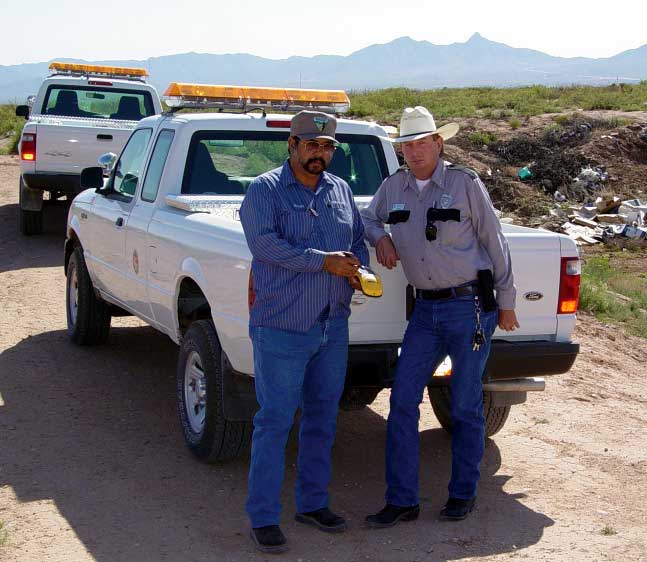
At 9:00 a.m. on a sunny day in early March 2004 the temperature is 65 degrees Fahrenheit. Birds are singing, and there isn't a cloud in the sky over this part of Do�a Ana County, New Mexico. The winds are calm, so far. Over the next few weeks, warm mornings will slide into hot days as the relentless summer heat of the desert asserts itself. Winds will blow almost daily, gusting nearly to hurricane forces. But on this particular morning in early March, it's birds and bright blue skies as Do�a Ana County's environmental code enforcement officers begin their first investigation of the day. Officers Richard Guerra and Jerry Ford are developing procedures to fight the illegal dumping of solid waste. The year before, Do�a Ana County became a leader in the state in environmental code enforcement. It was the first county in the state to hire officers dedicated to environmental code enforcement. The county has also enacted ordinances that include fines and imprisonment for illegal dumping. Although the county has had a mature desktop GIS in place for years, there was no way to effectively leverage that power for code enforcement fieldwork until a demonstration grant from Esri and Trimble brought mobile GIS to the county. Mobile GIS has helped Do�a Ana County modernize environmental code enforcement as it pertains to the illegal dumping of solid waste. Dealing With DumpingIllegal dumping is a problem faced by many rural governments. In areas where curbside trash collection is not available, residents sometimes find their own solution for disposing of household trash and other refuse. They dump it in remote or uninhabited areas. The vast stretches of open desert found in the county's 3,800 square miles provide such areas. The desert is crisscrossed by dirt roads and arroyos or the dry streams that fill with fast flowing water during the county's late summer monsoon season. The network of roads that provides recreational access to the desert for the county's 180,000 residents also provides easy access for illegally dumping solid waste.
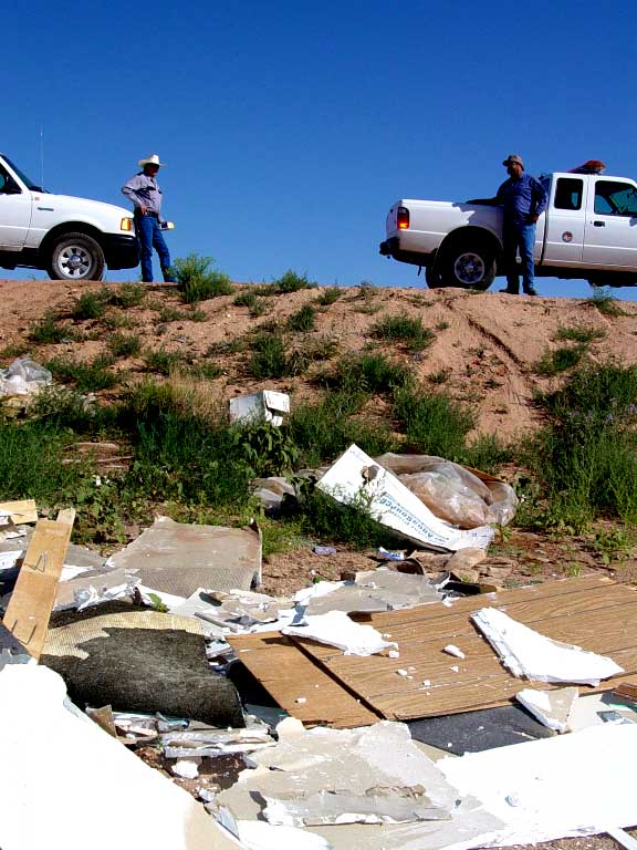
Do�a Ana County lies at the northern end of the Great Chihuahuan Desert in south central New Mexico. Its landscape features desert mesas, irrigated farmlands along the Rio Grande valley, and the young, rough peaks of the Organ Mountains in the San Andres Mountain Range. The terrain is the rugged, high desert of the American southwest and varies in elevation from a high of 9,012 feet above mean sea level at the top of the Organ Needle to a low of 3,729 feet above mean sea level at the point in the Rio Grande where New Mexico and Texas meet the Republic of Mexico. The varying terrain and stretches of undifferentiated desert make reconciling driving directions and sketched field maps to aerial photography in the GIS difficult. Mobile GIS has improved the accuracy of dump site location information by collecting GPS data that eliminates positional errors caused by misreading maps. Identifying Responsible PartiesOn this sunny day in March, Richard and Jerry are field testing a Trimble GeoXT GPS handheld device loaded with ArcPad and data from the county's GIS. A Las Cruces city councillor reported to the county commissioners that trash had been dumped along an irrigation ditch bank that appears to be county property bordering the city of Las Cruces. The councillor asked the commissioners to do something about this eyesore. In the office, the desktop GIS shows the ownership of the property at the site. The property on the city side of the border is privately owned while the property on the county side belongs to an irrigation district. On site, the uneven terrain makes it appear that the debris, which is mostly tree branches and trimmings, is piled on the irrigation district's property. As Richard photographs the site, Jerry uses the GeoXT handheld to record the physical location of the site, collect field data, and determine where the debris lies with respect to the city/county border. Mobile GIS can provide jurisdictional boundary information in the field. ArcPad is loaded with the county's parcel basemap, road centerlines, and jurisdictional boundaries. With the GeoXT handheld, the officers can answer jurisdictional questions by displaying their location on the map. At this site, debris has been dumped on both city and county land. Both city and county environmental codes prohibit dumping and storage of debris. The property owner arrives on site and Richard and Jerry explain the violation. The owner agrees to immediately have the site cleaned up. The county's size makes mobile GIS an ideal tool for field investigations. Prior to participating in the Mobile Government grant project, code enforcement officers gathered field data using pen and paper. They returned to county offices in Las Cruces and used the desktop GIS to locate sites under investigation, determine property ownership at the sites, and investigate any evidence that might indicate who was responsible for illegal dumping. Frequently, this information would lead the officers back to residences within a few miles of the investigation site. Taking GIS into the field has increased productivity and is saving fuel and other vehicle expenses by eliminating lengthy trips to the office. Continued on page 2 |