July - September 2004
July - September 2004 |
||||||||
|
|
||||||||
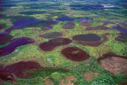
America's Everglades is a treasured national and international resource. Designated as a World Heritage Site, a Wetland of International Significance, and an International Biosphere Reserve, it is home to 68 threatened or endangered species, three national parks, 12 wildlife refuges, and a marine sanctuary. It includes Everglades National Park, one of the most biologically diverse ecosystems in all of North America, and Florida Bay, which has the only living coral reef on the continent. The Everglades was once a vibrant, free-flowing river of grass that provided clean water from Lake Okeechobee to Florida Bay and a haven for storks, alligators, panthers, and other wildlife. Human intervention began to change all of that in the late 1800s, when primitive canals were dug to drain south Florida. Changes continued throughout the 20th century as more than 1,700 miles of canals and levees drastically changed the landscape, interrupting the Everglades' natural sheet flow and sending valuable freshwater to sea. An ecosystem in peril, the Everglades is currently besieged with a number of problems-50 percent of its historic wetlands have been lost, its water quality has deteriorated and water flows have been disrupted, and vast quantities of fresh water have been lost to the system. The South Florida Water Management District (SFWMD) and the United States Army Corps of Engineers (USACE) have embarked on what has been termed "the largest restoration project in world history." The Comprehensive Everglades Restoration Plan (CERP) was approved by Congress and signed into law by presidential executive order in December 2000.
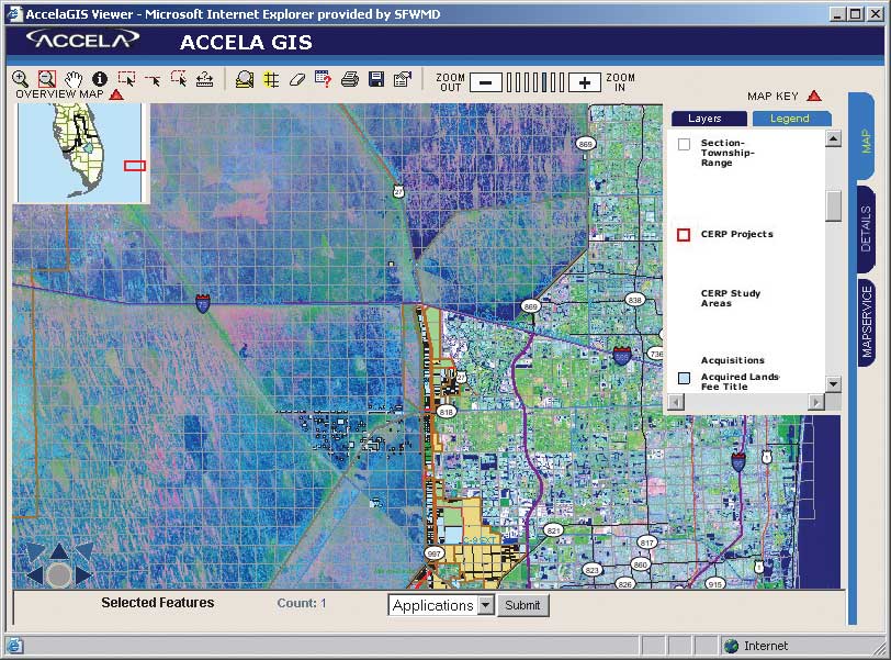
It is a $7.8 billion, 30-year plan to rescue the Everglades ecosystem through a series of specific ecological and water system improvements. During the next 30 years, the district; USACE; federal, state, and local agencies; tribal authorities; and private sponsoring partners will restore water quality, quantity, timing, and distribution. As part of this rescue plan, the South Florida Water Management District must purchase more than 400,000 acres of land at an estimated cost expected to top $2.2 billion. Legacy SystemsIn 1987, the district's Land Acquisition Department internally developed the Advanced Technology Land Acquisition System (ATLAS) to manage its real estate business information. This legacy system consisted of two related data stores-an Oracle database (ATLAS) and a GIS database. The ATLAS Oracle database was originally developed simply to hold the landowner's name, address, and district-assigned tract number. In the words of Dennis Meierer, senior supervising geographer, "ATLAS is no more than a glorified Rolodex." As the years went by, more than 168 related tables with thousands of fields were added to track the extensive land acquisition business process and ancillary information such as parcel numbers; county location; and section, township, and range data. The GIS database contained approximately 90 separate GIS data layers that represented project boundaries and were composed of 25,000 polygons. These GIS data layers were maintained as Esri coverages and edited in ArcInfo Workstation using ArcEdit and ArcPlot. ArcView's mapping tools were employed for map production. Unfortunately, the GIS data layers replicated data stored in the ATLAS Oracle database. Maintaining redundant information in these separate databases had obvious drawbacks. Beyond problems with inefficiencies caused by redundancy and inconsistency, much of this data was fundamental to the district's major projects and programs. Gathering and storing this data in databases and systems that were relatively isolated from one another meant that related mission critical information could not be easily or quickly accessed, shared, processed, or analyzed. Like other early GIS systems, these isolated data stores evolved as the result of differing mandates, business systems, and technologies. This situation had developed as a result of incompatibilities between hardware and software and was the inevitable consequence of formal and informal processes established over the years for gathering and storing information for use by individuals, divisions, and departments. In the course of implementing policy directives and completing mandated projects to protect the water resources of more than six million people in the region, information processing solutions were often developed in isolation to quickly meet immediate and specific needs. Furthermore, adequate solutions that could integrate disparate technologies did not exist until recently. These legacy systems were inadequate to fulfill the needs of the mandate set forth in the Comprehensive Everglades Restoration Plan. A Vision for Sharing Data and TechnologyMany of the district's most important projects are dependent on the broad and seamless use of GIS, the Web, and database systems. The Information Technology Convergence (ITC) initiative is the district's vision for making sure these technologies work together to help staff and the public analyze, store, and distribute critical data and information. Integrating this information will make many types of information widely accessible and enable more effective analysis and decision making. Integrated data will be easier to maintain and use, which will increase staff productivity and efficiency while reducing redundant efforts and significantly improving quality control and data integrity. Given these benefits, data integration was recognized as a prudent investment for the district's Land Acquisition Department. Continued on page 2 |