County Cuts Costs and Improves Response
A new code enforcement strategy based on mobile GIS is saving a California county both time and money.
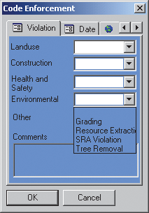 |
| The form developed for code enforcement officers incorporates drop-down boxes that list the codes used by the county to classify violations. |
In San Luis Obispo County, California, most health and safety and environmental damage violations occur in the sparsely populated, unincorporated portions of this rural county. Just five code enforcement division officers are responsible for the county's more than 3,300 square miles, an area characterized by unimproved dirt roads that slow travel.
Not only must officers deal with a large service area but they must also meet performance measures currently in force, which mandate an investigative response time of less than three days for health and safety violations and 48 hours for environmental damage violations.
These requirements for timely response can only be met if the owner of the property in violation can be easily identified, typically through a street address. However, in many parts of the county, identifying the location and owner of a property in violation can be problematic and this can delay response and incur significant cost.
Tracking Down Owners
Before the new GIS/GPS system was implemented, code officers would try to locate the nearest identifiable property adjacent to the property in violation. The neighboring property could be next door or miles down a dirt road. After using an assessor's parcel map to guess at the property location and query for the mailing address for that parcel, a "please call" letter was sent to the owner.
If the owner did not respond, the investigation ground to a halt until the California Highway Patrol could be enlisted to fly the area in question and acquire coordinates for parcel. With latitude and longitude coordinates, the Mapping and Graphics Section of the Planning Department could identify the parcel and owner. This cumbersome process could take as long as 45 days and cost from $575 to $1,175, depending on whether a helicopter or airplane was used to identify the property.
Looking for a Better Way
The county applied for an Esri/Trimble Mobile Government grant. Through providing software, hardware, and training totaling $140,000, the grant program hopes to meet the dual goals of helping agencies implement innovative GIS and GPS applications for improving government processes and generating reusable applications that can be shared with users via Esri's public domain Web site. Recipients, selected from local government organizations in the United States, represent a wide range of disciplines including health, code enforcement, public safety, planning, public works, and parks and recreation.
In November 2003, San Luis Obispo County learned it was one of 10 government agencies that received a grant. After receiving the grant software and hardware, county staff set about implementing a new work flow. Andrea Miller, a mapping/graphic systems specialist for the county's planning and building department, completed two Esri Virtual Campus courses, Working with ArcPad and Customizing ArcPad. Miller decided to use a VBScript downloaded from the Esri ArcScripts Web site to generate a form rather than create one from scratch. She used the Layer Form Creation wizard to produce a customized form for the county's code enforcement officers.
The first page of the form lists property identification information, the second page describes violations, the third page holds the date, and the fourth page contains GPS coordinate information. Closing the form triggers a table update. The form's drop-down boxes incorporate the codes used by the county to classify violations, and data fields are set to the data storage locations for those items.
Saving Time and Money
With the GIS/GPS method, the investigative process has been streamlined and requires only one trip to the site. After locating a property in violation, the code officer uses GPS to identify the parcel and GIS to look up the ownership information. The details of the violation are quickly recorded. After returning to the office and opening a case, a "please call" letter can be immediately sent to the owner.
This process eliminates not only the cost of having the California Highway Patrol locate a parcel but also staff time expended tracking down a parcel's ownership. The owners of neighboring properties no longer need be contacted. Over an average month, this can mean a savings of 225 hours and $26,875, and it also means officers can meet the county's performance standards.
Building on Success
With the time and money saved, the division has purchased two more copies of ArcPad and two additional Trimble Pocket GPS receivers so more officers will be able to operate efficiently in the field. Plans to further automate this system include integrating this program with a new permit tracking system from Esri business partner Tidemark so new case creation will be batch processed. A similar program is being considered for the county's building inspectors.
The script created by Miller for locating rural land use code violations has been posted on the Esri ArcScripts Web page and can be found by searching on "Code Enforcement GPS Mobility Program." It allows a code officer to locate the parcel in violation, see ownership information, and record the type of violation for reporting purposes. The form's attributes are the assessor's parcel number, ownership information, type of violation (supplied through a drop-down list), date, and comments. To download a copy of this template, visit www.esri.com/arcscripts. For more information on this application, contact Andrea Miller at amiller@co.slo.ca.us.
|