July - September 2004
July - September 2004 |
||||||||
|
|
||||||||
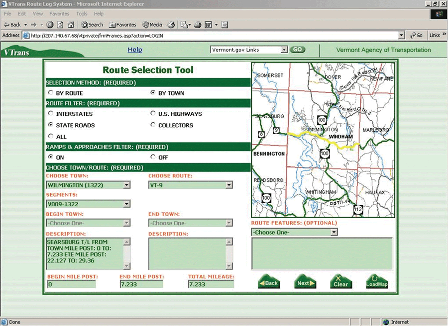
Selected infrastructure information—such as rail crossings, bridges, and traffic signals—was symbolized with accompanying horizontal data bars. Data bars displayed roadway attributes including pavement history, crashes, and traffic volumes. Until recently, the route logs, infrastructure information, and roadway attributes were maintained by VTrans manually. Staff cutbacks and difficulties in data gathering made keeping this information current problematic. The prior use and acceptance of route logs throughout VTrans prompted management to initiate a project for automating route logs using GIS. VTrans decided to leverage this effort with a spatially enabled data warehouse that was already being developed. VTrans contracted with Esri Business Partner GeoDecisions and Esri for assistance and support in designing and developing an automated, interactive RLS solution. Using a Two-Pronged ApproachThe solution needed to serve two types of users: many casual, nontechnical staff members and a smaller group of power users who required greater functionality and high-volume output capabilities. The team decided to develop two separate but linked applications. An easy-to-use, Web-based application designed and deployed for the first set of users uses ArcIMS and ArcMap Server. ArcMap Server renders characteristics of the current VTrans GIS basemap and handles dynamic segmentation display and analysis. ArcIMS map services generate route selections and user location maps images. The resulting images are passed to the Web application. The Web application uses scalable vector graphics (SVG) to render the graphic elements of the route log. SVG tools are used for functions such as route log panning, zooming, and overposting control. The second application developed for power users is a desktop solution that runs at the ArcView license level and was built with ArcGIS 8.x and ArcObjects and customized using Visual Basic. Common ElementsBoth RLS solutions share common elements that include direct access to the Microsoft SQL Server 2000-based VTrans data repository and incorporation of ArcSDE layers. Data being served through ArcSDE is extracted from various systems: pavement management, traffic monitoring, bridge inventory, and other original data sources. This eliminates redundant data entry, allows timely updates, and provides end users with comprehensive datasets. The applications use shapefiles and event tables to dynamically display maps and business attribute data. The basic layout of the data is a stick diagram with horizontal data bars, similar to the original hard-copy route logs. In addition, customizable GIS map layers are available to support the interactive display of the user's current viewing location. Users can select routes from pick list menus and interactive maps or from stored, shareable templates. Specific routes (e.g., interstate, U.S., state, and collector highways and ramps) can be viewed by route type and number or town. Display parameters such measurement units (e.g., English, metric) and referencing systems (e.g., end-to-end or town based). The attribute data that can be displayed includes curve and grade data, historic projects, sufficiency rating, roadway width, traffic data, speed zone, and crashes. Power users can also display personal data stored in Access databases, dBASE (DBF) files, and other data formats. The resulting display contains dynamic viewing and measurement tools for VTrans users. The Web application includes a moveable measurement guide, mouseovers, and clickable data displays for bridges, intersecting roads, and railroad crossings. It also offers users the direct display of database fields and legends, overposting, and magnifier tools. The desktop application, designed for power users, includes an interactive locator tool and a special description block for the display of structure information. It also offers users more extensive options and the ability to customize and batch print route logs. Both versions of the application can be viewed in shorter or longer sections at a time, and map and data layers can be turned on and off. Both applications feature seamless display that enables horizontal scrolling of an entire route or selected portions. "The Route Logs System allows decision makers to leverage agency data and view many disparate datasets in an efficient and comparable format. The user has the ability to query the wealth of the databases behind the graphics on the log and see details about specific features of interest," said Johnathan Croft, RLS project manager for VTrans. Project DevelopmentFrom the development of prototype applications through several interim versions, the product development spanned 18 months. During development, VTrans, GeoDecisions, and Esri collaborated closely, performed testing, and obtained feedback regularly. The final rollout and training of the RLS took place in December 2003. Phase 2 of the project will add more functionality, data, and multimedia elements such as videolog viewing; the ability to overlay digital orthophotography; and links to design drawings, plans, and other document imagery files. Road elevation profile data will also be available. The automated RLS solution has demonstrated a successful method for easily viewing and manipulating enterprise business data, as well as providing users with access to more current information. Users can view disparate data types for a section of roadway in an integrated manner from the desktop. This eliminates time-consuming data hunting and visits to the field. In addition, the improved quality of the data has increased users' confidence in the system. Comparing and analyzing current, high-quality data through the automated RLS system will help identify problem areas on roadways, improve highway safety, and ultimately lead to more efficient prioritization and execution of roadway improvement projects. For more information on the VTrans Automated Route Logs project, contact Johnathan Croft, GIS Database Administrator About the AuthorDon E. Kiel is a senior project manager at GeoDecisions in State College, Pennsylvania, who has been active in GIS and transportation work since 1984. He earned a bachelor's degree in geography from the University of Akron and a master's degree in geography from Virginia Polytechnic Institute and State University. He has taught GIS classes at the college level, published numerous papers, and given many presentations on GIS transportation applications. |