July - September 2005
July - September 2005 |
||||||||
|
|
||||||||
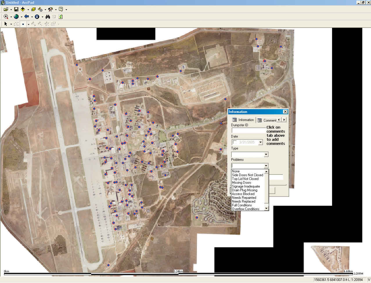
However, before data could be collected, a list of attributes for describing each dumpster was needed. With input from the flight's members, the attribute requirements were developed. A list of domain choices, agreed upon for each attribute, further simplified the process. Typing text into a handheld GPS unit or a PDA can be time consuming and difficult. A list of meaningful domain choices in a pull-down menu reduces the time needed for entering attributes. These lists ensured all locations were attributed in the same way, no matter who entered the data, and eliminated the need for note interpretation back at the office. Eliminating variations in spelling meant data queries could be performed easily. For example, the attribute choice for a dumpster in need of repainting is "Needs to be repainted." If this attribute is not a list choice, someone might type the words "paint" or "repaint." Without attribute standardization, a query for all dumpsters that need to be repainted might not reveal every dumpster that requires repainting. Although attribute domain lists can save time, an issue can come up in the field that is not listed, so an additional comment field was added to capture pertinent information about a dumpster. After the attribute and choice list was developed, the GeoBase team used ArcPad Application Builder to design a custom form tailored to this project.
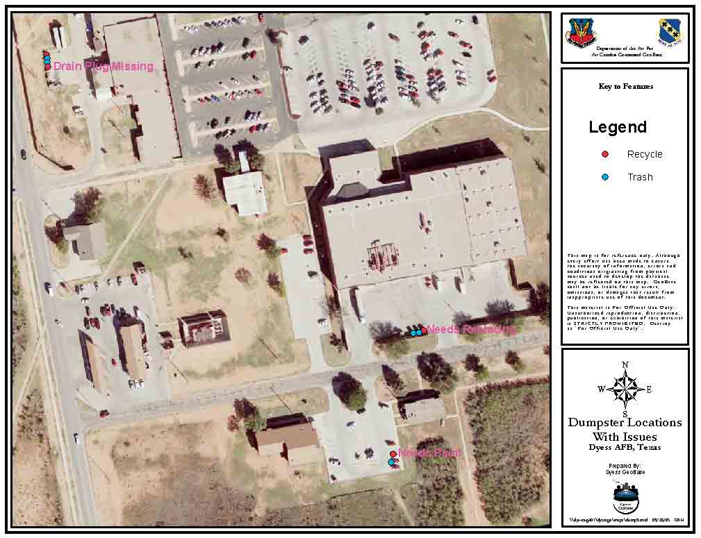
One advantage of Form Editor is that once the attribute and domain lists are developed they can all be incorporated into one table. Each field on the form can be linked to the appropriate column in the table so attribute choices populate the table. Using one table for each form makes developing this table quite simple, and cross populating from multiple tables is not an issue. For ease of use, the form was kept as brief as possible. Although Application Builder allows forms to contain multiple pages, the page count was kept to the minimum number needed to collect the required data. The first page of the project form contained all the information required for the survey. A unique identifier for each dumpster was generated by combining the building number associated with the dumpster followed by an "R" for recycle or "T" for trash. The unique identifier can be used for table joins and record maintenance. With Form Editor, the time and date can be automatically captured. This is important to the dumpster survey collection process. Form Editor obtains the time from the Windows CE OS and the date from the GeoXT device and automatically enters this information in the attribute table. The dumpster attributes collected on the first page of the form are the dumpster number, type (trash or recycle), time and date surveyed, problems with dumpster, and serial number. A small note on the first page tells the user to scroll to the second page to add more notes, if needed. The second, optional page of the form is used to capture notes that don't fit elsewhere on the form but are deemed important by the user. Implementing a Better SystemWith the collection team trained and the form developed, the dumpster data was collected in two days by one person and produced a highly accurate inventory. This represented a 90 percent reduction in the number of man-hours required for this task. When the data was returned to the GeoBase office, it was imported into ArcGIS, analyzed, and plotted on a map to determine which areas of the base lacked proper trash and recycle services. Now locations with greater demands for dumpster capacity and the physical condition of dumpsters can be monitored. Sites with dumpsters that have above-average damage rates can be identified and investigated. The situation can be mitigated by changing the unit's location, upgrading the traffic protection, or employing a different unit type to minimize damage while maximizing volume throughput. Attributes gathered through field surveys are uploaded to the ArcSDE geodatabase and placed in a table that is joined by a unique ID. Information is grouped by year for future use in identifying trends and record keeping. Using these new techniques has allowed Dyess Air Force Base to get an accurate inventory of the dumpsters on base and ensure contract services are fully realized. Benefits in Service and SavingsHaving an inventory that accurately counts and locates dumpsters seems like a very simple goal but, in practice, it is difficult to achieve. However, the benefits to the base resulting from this improved data collection method are many. A more accurate inventory revealed that 20 percent fewer dumpsters were being employed than required by contract. In response to this finding, the number of dumpsters was increased by 20 percent at no additional cost to the base and this has resulted in better service to customers. With exact dumpster location information, analysis could be made of the most appropriate locations for dumpsters in relation to vehicular and pedestrian traffic patterns. Each dumpster was logged for routine maintenance so the quality assurance evaluator could verify the dumpsters were repaired correctly and in a timely fashion. Problem areas resulting from the misuse of dumpsters by customers were identified and are being handled through education and outreach sessions. The 90 percent saving in data collection time coupled with an easily updated dumpster inventory and maintenance listing has made this project a winner for Dyess Air Force Base. For more information on this project, contact Robert Houston at robert.houston@dyess.af.mil. About the AuthorsRobert Houston is the GIS analyst contractor from Earth Tech, Inc., serving the ACC GeoBase program at Dyess Air Force Base. Sean Sinclair is the GIS technician contractor from Earth Tech, Inc., serving the ACC GeoBase program at Dyess Air Force Base. He may be contacted at sean.sinclair@dyess.af.mil. James (Jim) Robertson is Chief of the Projects, Programs and Analysis Section and is the Geo Integration Officer at Dyess Air Force Base. He may be reached at james.robertson@dyess.af.mil. Note: Use of trade names and commercial sources is for identification only and does not imply endorsement by the U.S. Department of Defense. |