Bringing GIS Modeling to the New ArcGIS Generation
By Maria Isabel Martinez, Jones, Edmunds & Associates, Inc.
Florida's ever-increasing population comes at a price. New development places increasing demands on water resources and puts pressure on the water quality of lakes and rivers. State and local governments must keep up with new developments while protecting the state's natural resources.
To meet these challenges, the St. Johns River Water Management District developed the 1995 District Water Management Plan (DWMP). This plan helps local governments resolve water management issues and make planning decisions. These efforts involve 18 counties in northeast and east-central Florida. To support this plan, district staff created the Pollutant Load Screening Model (PLSM). This GIS watershed model is a tool for estimating runoff and annual pollutant loads. DWMP identifies potential storm water runoff problem areas. This information helps local governments make land and water planning decisions.
The New GIS Generation
The PLSM was originally developed using ARC Macro Language (AML) in ArcInfo 7.2 GRID and has been used by scientists and engineers in watershed modeling. Since PLSM was developed in the 1990s, ArcInfo has undergone significant interface and data management changes. AML has been replaced as the main programming language for tool development with other languages such as Visual Basic or Python. Consequently, new GIS users are not familiar with AML, which has limited its use.
The district has fully implemented the changes in ArcInfo, and GIS users are becoming very familiar with the new ArcGIS. Of particular interest is ModelBuilder, a graphic modeling framework for designing and implementing geoprocessing models that can include tools, scripts, and data. It was incorporated in ArcGIS at version 9.0. ModelBuilder provides a good transition program for replicating the processes of PLSM.
The advantages of using ModelBuilder are many. Like in AML and other programming languages, ModelBuilder automates processes. However, it does not require programming. Models are easily created in ArcToolbox, and existing models can be customized by any user. In addition, ModelBuilder works with both vector and raster data files. Users can create documentation for each process and have easy access to help files.
ModelBuilder also allows staff better access to data and software. With previous versions of ArcInfo, access was limited to advanced GIS users who were familiar with the command line environment. ArcGIS has been installed on every personal computer at the district, which gives all employees the opportunity to be involved in GIS work. Also, the district provides several opportunities for staff to be trained to competently use ArcGIS.
Understanding PLSM
The first step in moving PLSM to ArcGIS and ModelBuilder was to understand the model's processes and parameters. The AML-based PLSM runs in ArcInfo 7.2 GRID and uses five input grids-existing land use, drainage basin boundaries, rainfall, soils, and future land use-as well as several remap tables [i.e., tables used to reclassify grid data]. All the input files must be prepared prior to running the model, which executes without user interaction.
The overall process starts with the calculation of runoff for each land use and soils combination within the study area. Runoff is determined by multiplying average annual rainfall, a runoff coefficient that depends on soil and land use type, and the area of the basin under study. In the next step, the annual pollutant load is calculated for different parameters such as total phosphorus or total nitrogen. Annual load is determined by multiplying runoff by a runoff pollutant concentration coefficient that depends on the type of land use. The last step adds storm water treatment efficiencies to runoff. Storm water treatment facilities are designed to improve the quality of runoff before it enters water bodies, and their impact is added to PLSM through efficiency values.
The AML outputs annual load grids that let users visualize the areas that contribute different pollutants and a summary of the annual loads by drainage basin. When PLSM was developed in the 1990s, it was run for every drainage basin in the district and the results were outlined in a report.
Translating PLSM into ModelBuilder
The new PLSM runs in ModelBuilder using either ArcCatalog or ArcMap and requires an ArcInfo license. The three calculations in the model are divided into four steps. Separating the process into steps allows users to review outputs at every point in the process, allows for error checking, and it also speeds the process.
A new initial step, called Preparing Data, was added to the ModelBuilder version of the PLSM. Users can select input files (e.g., existing land use, soils, rainfall, and remap tables) from the district's GIS library. This step was added so users can use district-wide GIS files as input data and select drainage basins interactively. Because input files are selected interactively, the input study area can change from a drainage basin to a county or city boundary without additional work. Originally PLSM worked after the study area had been selected so additional work was needed prior to running the model to change the study area. Input files in this first step are entered in vector format and converted to raster later in the process.
Steps two through four prepare grids and perform calculations for runoff and annual loads and apply storm water efficiencies in a manner similar to the AML process. However, the ModelBuilder version allows more user interaction and error checking at every step.
The ModelBuilder version of PLSM is run from a dialog box. Input files, output locations, and other variables are set as parameters when building the models. These parameters display in the model's dialog box so users can set them interactively rather than using constant values and customize the model. In addition, each parameter has documentation in the help menu so users can understand the process, read about the geoprocessing tool that is run at each step, and look at examples. The ModelBuilder outputs are annual load grids that allow users to visualize areas that contribute different pollutants as well as a summary of the annual loads by drainage basin. Results are also outlined in a report.
Final Thoughts
This project is one example of how older—but still functional—tools can be rebuilt for new technologies. This five-month long project will allow more GIS users and scientists, and engineers who are familiar with ArcGIS, to continue using PLSM as a screening tool for the surface water quality model. The flexibility of ModelBuilder allows staff to customize and even extend the model to meet their needs without changing the entire program. In addition, detailed documentation in the form of model diagrams and help files allows staff to better understand how the model works and its results. For more information, contact
Maria Isabel Martinez, GIS Analyst
Jones, Edmunds & Associates, Inc.
Gainesville, Florida
Tel.: 386-329-4815
E-mail: mmartinez@jea.net
About the Author
Maria Martinez is a GIS analyst at Jones, Edmunds & Associates, Inc., in Gainesville, Florida, who works as a consultant at the St. Johns River Water Management District providing GIS support to scientists managing water resources in central Florida. She earned a bachelor's degree in natural resources conservation at the University of Florida. Jones, Edmunds & Associates is an Esri business partner.
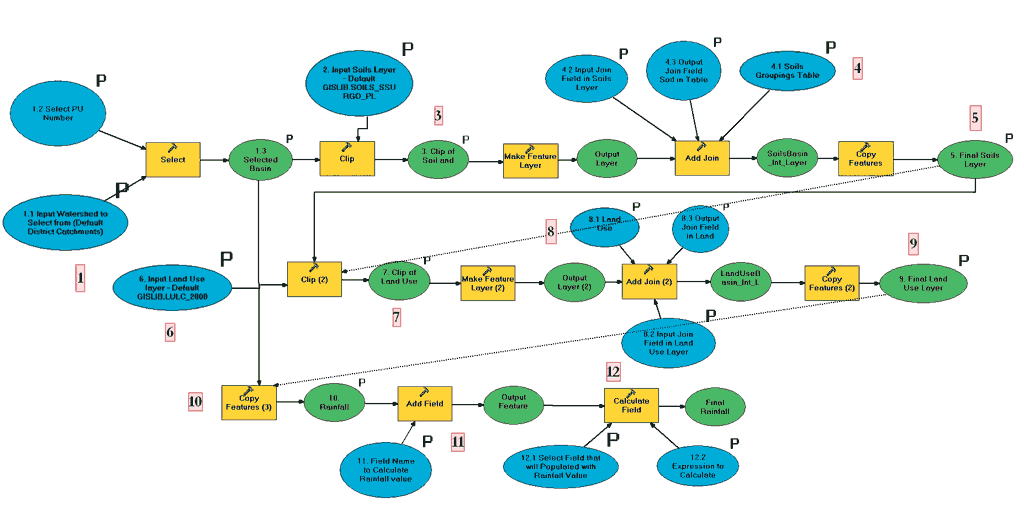
Pollutant Load Screening Model—Step 1
Step 1 is data preparation. The following processing steps happen at this time:
- Select watershed from GIS library (user input).
- Select soils layer from GIS library (user input).
- Intersect soils and watershed (output).
- Join soils attribute table to a soils groupings table (user input).
- Copy joined soils layer to a new location (output).
--The next steps do not happen until the final soils layer has been created.--
- Select land-use layer from GIS library (user output).
- Intersect land use and watershed (output).
- Join land-use attribute table to a land-use grouping table (user input).
- Copy joined land-use layer to a new location (output).
--The next steps do not happen until the final land-use layer has been created.--
- Copy basin boundary as a new layer and call it Rainfall.
- Add a field to the attribute table.
- Populate field with rainfall value.
See program metadata and documentation for more details.
|