July - September 2005
July - September 2005 |
||||||||
|
|
||||||||
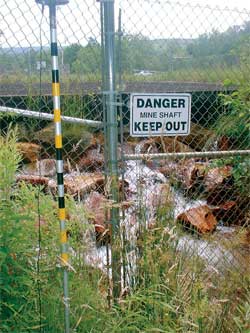
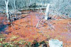
In addition to abandoned mine drainage (AMD), agricultural runoff also is a major contributor of nonpoint source pollution in the area. Previous studies reported that between 1,800 and 2,400 tons of AMD per year are seeping into the Casselman River. The Casselman River Watershed has been categorized by the Commonwealth of Pennsylvania and the Environmental Protection Agency as having the highest restoration priority. The Casselman River Watershed Alliance has been working for many years to address AMD and agricultural runoff pollution problems in the watershed. Partners in this alliance include the Casselman River Watershed Association, the Southern Alleghenies Conservancy, and the Somerset Conservation District. Although considerable progress had been made improving water quality, much work remained. The Somerset Conservation District received a Pennsylvania Department of Environmental Protection Growing Greener Grant to complete a comprehensive nonpoint pollution assessment of the Pennsylvania portion of the Casselman River Watershed. This assessment, the Casselman River Watershed Major Nonpoint Source Pollution Assessment and Restoration Plan, is part of a long-term effort to restore the watershed. The project, started in 2001 and completed in 2003, assessed approximately 370 square miles of the Casselman River Watershed. In addition to assessing nonpoint source, the project had an additional goal to produce a restoration plan that would guide future restoration activities. GIS had a major role in the success of the project. It was used to compile relevant watershed information (past, present, and future) for analysis. GIS served as the backbone for the watershed and water quality analysis by gathering together key data and analytical components for review and analysis. Structured to provide a multitude of future assessment and analysis opportunities, the GIS is being constantly updated and augmented while the restoration plan is being implemented. GIS helps manage a variety of watershed restoration efforts.
During the assessment phase, GIS was used to determine the location, types, extent, and impacts of the most severe AMD discharges and identify areas with high potential for agricultural runoff. Data sources included United States Geological Survey topographic mapping, aerial photography, historic water quality and quantity results, and field-generated data. Using a GPS receiver, each identified discharge was located. More than 200 AMD discharges were identified and field verified. Of those discharges, 39 priority AMD discharges were selected and monitored. The water quality sampling program focused on flows from the priority AMD discharge sites, AMD impacted tributaries, and the Casselman River main channel. Using the GIS, optimum locations for each sampling station were identified. The priority AMD discharges were indexed, ranked, and prioritized. Treatment approaches and cost estimates were prepared to guide future remediation efforts. To assess the feasibility of these options, a computer program called AMDTreat was run for each discharge. AMDTreat provides users with a method for predicting and modeling water treatment costs for mine drainage problems. It compared treatment option design requirements, capital cost, and operation and maintenance cost. To identify areas with the highest potential for agricultural runoff, agricultural lands in the watershed were digitized. Stream stretches with inadequate riparian zones were digitized and added to the GIS to establish locations with high potential for agricultural runoff. This assessment focused on providing a planning tool for improving water quality in the Casselman River and its tributaries by reducing the impacts of agricultural nonpoint pollution sources. Information for three primary agricultural-related criterion—total acres of agricultural land, total length of stream bank with inadequate riparian buffer zones, and total length of stream bank with inadequate riparian buffer zones through agricultural land-and agricultural nonpoint source screening results were used to assign a high, medium, or low priority to each subwatershed within each planning area. GIS was instrumental in calculating the acreages and lengths for the primary agricultural criterion.
In addition, GIS was used in conjunction with data in Microsoft Excel spreadsheets to support assigning restoration priorities for each AMD discharge. Based on the scoring and prioritization process, a structure for listing the discharges in an organized fashion was developed. Discharges were prioritized, based on the overall goal of reducing AMD pollution. More subjective criteria influenced the order of restoration within the individual subwatersheds. Based on the analysis of all AMD nonpoint pollution data, a top-down (i.e., upstream to downstream) watershed/subwatershed restoration approach was recommended. Specific objectives achieved through the successful completion of the plan:
Although the restoration plan was completed in fall 2003, its has led to immediate remediation efforts. Based on project recommendations highlighted in the plan, Somerset Conservation District is currently finalizing the design of an AMD treatment project for Coal Run, ranked as the third highest contributor of AMD loadings, and has also applied for funding to design and construct treatment systems on Shaw Mine Run, ranked as the second highest contributor of AMD loadings. The project is realistic and targeted and has exceeded its intended objectives. It is currently being implemented, and its success is evident in the watershed. Somerset Conservation District is scheduled to begin collecting detailed agricultural operations information from farms located in the high-priority watersheds identified in the plan. The district can efficiently target sites with high runoff potential and is moving toward adopting best management practices for agriculture in these watersheds. The Casselman River Watershed Major Nonpoint Pollution Assessment and Restoration Plan project received the 2004 Karl Mason Award. This award is given to a Pennsylvania person, organization, or project that has made a significant contribution to the betterment of Pennsylvania's environment. For more information, contact Mark W. Lazzari, Planner/GIS Specialist About the AuthorMark W. Lazzari is a planner/GIS specialist for Paul C. Rizzo Associates, Inc. He holds a bachelor's degree in biology and psychology (double major) from Grove City College, a master's degree in earth science from California University in Pennsylvania, and a master's degree in geography and regional planning with an emphasis in community planning from Indiana University in Pennsylvania. He is a member of the American Planning Association and the Society of Wetland Scientists. He has worked on a variety of GIS mapping and planning projects related to flood projection and GIS and database development for municipal governments in addition to work on the Casselman River Watershed project. |