Mapping Better Business Strategies
Integrating GIS and Business Intelligence
Business Intelligence (BI) is the software applications, technologies, and analytical methodologies for analyzing and reporting on standard data types. This broad definition may remind ArcUser readers of another horizontal technology—GIS.
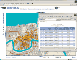 |
| With a few hours of training, field investigators and supervisors in the Department of Social Services can use the WebFOCUS application to map the distribution of suspicious food stamp transactions. |
BI is a term that really describes a continuum rather than a single solution. From early applications such as simple reporting and querying, BI has grown to encompass data warehousing; data, Web, and text mining; online analytical processing (OLAP); data visualization, and sophisticated reporting and querying capabilities. BI, developed to give Fortune 500 companies a competitive edge, has grown to become a multibillion dollar industry itself. Financial services, banking, insurance, manufacturing, telecommunications, and health care were early adopters of BI and have benefited the most from this technology, but many other sectors are not far behind in realizing the benefits of this technology.
The Where in BI
Much like GIS, BI provides decision support through marshalling detailed and disparate information. BI tools are applied in many similar areas-risk analysis, customer analytics, site selection, territory management, market analysis, and customer relationship management (CRM). These tools excel at extracting the who, what, and when aspects of data but are lost when it comes to the where of data. This is true despite the fact businesses typically collect an array of addresses relating to each customer. The lack of where in BI has been more of a conceptual failure-the inability to see the value of location information beyond its place on a mailing label-than data lacking a spatial dimension.
Finding the Where of BI
Location provides a framework for understanding relationships within datasets and between different types of data. GIS practitioners have long been aware of this fact but the business community, and BI users specifically, are just becoming aware of the synergy between these two integrating technologies.
BI analysis is one of the most empowering tools for executives. Combining BI with GIS adds new analytical capabilities. Knowing the where component makes other kinds of data accessible. Third-party resources, such as Dun & Bradstreet data, can be joined with in-house data based on location for a more profound look at customers. BI and GIS are complementary, rather than competing technologies that, together, can enlist additional information and make better decisions possible.
New Data Insights
The old saying "seeing is believing" should really be "seeing is understanding." People are visually oriented. It is how we most easily process information. To understand something deeply is to have "insight" about it.
However, a more robust method for visualizing and comprehending BI data is needed. Charts and graphs, the standard visualization aids available to BI users, are not suitable for conveying information at the level of detail now commonly produced by BI tools. Attempts to synthesize this complexity into a pie chart is ineffective and may simply overwhelm, rather than enlighten, the user. Also, the ability to interrogate charts and graphs to uncover other aspects of data is quite limited.
Many of the questions BI seeks to answer, such as exploring the demand for a product or service in an area or deciding where to locate a store, are intrinsically geographic activities. Unlike either a CAD or graphics program, GIS can fold many layers of data into the analysis and use powerful tools, such as grid surfaces, that translate complex data into useful and understandable representations that incorporate many factors.
Using GIS to visualize the results of BI analysis is vastly more powerful than using a graphic representation or CAD drawing because both lack real-world context. GIS relates data to a specific location on the earth. Only GIS can use the results of data exploration and analysis and apply them to optimize activities such as delivering products or routing repair people.
Large retail stores have realized this and gained a competitive edge in a very competitive market. Combining GIS and BI allows these companies to manage the repair technicians and delivery personnel that must visit millions of homes each year. Intelligently handling this workload entails much more than routing service vans. BI combined with GIS has helped retailers forecast demand and allocate resources, resulting in improved technician productivity, reduced overtime, and lowered truck expenses per stop.
Communicating Results Effectively
The ability of a map to condense a wealth of information into a visual image is readily apparent to anyone who has ever tried to give directions. Typically, about a paragraph into the long narrative needed to guide someone to a store or a house, the person giving the directions will become exasperated, grab any handy scrap of paper, and start sketching a map instead. Maps have long provided an economical and elegant method for making detailed and interrelated information quickly comprehensible.
Adding maps to BI brings a new kind of competitive advantage not only by allowing decisions to be based on more data and more kinds of data but also by communicating the resulting information in a way that is readily understood.
The enhanced analysis and communication possible when GIS and BI work together are being recognized by the BI industry. This realization was neatly summed up by leading BI specialist Michael L. Gonzales in his presentation at the Esri Business GeoInfo Summit in 2005, "without spatial visualization, we are only reporting the obvious."
Continued on page 2
|
