|
The Magazine for
Esri Software Users |
|
|||
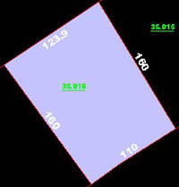
Integrating Cadastral Mapping into Local GovernmentBy L. Ethan Southern and Jay ArnoldBaldwin County (BC) is located on the southern coast of Alabama. BC, the largest and second fastest growing county in Alabama, covers more than one million acres and consists of more than 90,000 parcels. The Baldwin County Revenue Commission (BCRC) contracted Southeast Digital Mapping (SDM), of Mobile, Alabama, and Esri business partner 3001, Inc., of Gainesville, Florida, to develop a comprehensive parcel management GIS to better deal with the area's rapid economic and demographic growth.
This project is an interesting illustration of the many challenges facing modern GIS developers. The BCRC saw the need for a comprehensive GIS, but had to be able to integrate its existing Computer Assisted Mass Appraisal (CAMA) database and information from hard-copy maps into a new digital spatial format for use with NovaLIS Parcel Editor for ArcInfo. In addition, several BCRC users must be able to edit the spatial database simultaneously and have all changes integrated into the master database files. The final product of this project supports multiuser access, spatial analysis, retrieval of data from the CAMA database, and high-quality cartographic output. Converting the DatabaseIn the first step, the existing BCRC data was converted into a digital database in ArcInfo format. The original Mylar hard-copy map sheets were scanned and converted to vector format. The BCRC database design manual, created during a previous project with another vendor, specified separate data layers for many of the map features. In all, 186 individual map feature types were captured in CAD format and grouped into 12 ArcInfo coverages. The database design separates items such as public land survey grids, parcel polygons, and historic lot lines. Since all these features are present side-by-side on a single Mylar map sheet, 3001, Inc., had to develop a set of custom tools that recognized the unique attributes of each type of feature and populated the right groups with the right line work. The program recognizes each feature type present in the scanned maps and places each feature type in a discrete data layer. ArcInfo LIBRARIAN was used to format the database for multiuser access. Though ArcInfo LIBRARIAN was chosen for the initial implementation on ArcInfo 7.2.1, rather than ArcSDE; the ultimate goal is to migrate to ArcSDE within the next two years after upgrading to ArcInfo 8. ArcInfo LIBRARIAN creates a digital spatial library that functions much like a traditional library of books. ArcInfo LIBRARIAN partitions the digital database into files of manageable size. Users can check out ArcInfo LIBRARIAN tiles in the same way a library patron checks out books. ArcInfo LIBRARIAN records which user has checked out which tiles and prevents concurrent updates. A tile that is checked out is unavailable for editing until it is checked back in. Developing Custom ToolsWith the database operational in ArcInfo LIBRARIAN, the next step was to develop custom tools and configure the system to work with NovaLIS Parcel Editor 3.3. The Parcel Editor is an ODE-based application that operates on top of ArcInfo. With support for macro development inside Parcel Editor, custom functionality is being added to the final BCRC system using ARC Macro Language (AML) scripts and Visual Basic (VB) code. The final implementation will integrate all 90,000 parcels into Parcel Editor and make them widely available as ArcInfo coverages or ArcView GIS shapefiles. The BCRC is providing copies of the data sets to other agencies throughout the County. The new system will incorporate existing parcel data in a fully digital environment that will allow for faster access to the system with a decrease in maintenance and update costs. Baldwin County Appraisal DepartmentThe Baldwin County Appraisal Department (BCAD) uses the CAMA database to query sales information. The inability of the CAMA database to spatially represent sales information was a limitation. Updating sales information on parcel maps involved pulling the hard-copy parcel maps and physically writing sales information in the map for each parcel. This updating process was time-consuming and did not let the appraisers take parcel maps into the field.
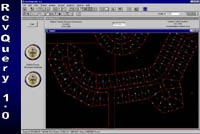
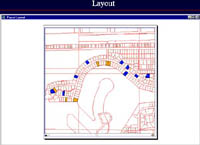
The current version of the DELTA application that accesses the CAMA data was developed by Delta Computer Systems of Gulfport, Mississippi, for BCRC. This application operates on an IBM AS/400. Queries of sales data on this system are limited. Sales can only be queried by a single year, multiple codes (for neighborhoods, bedroom count, acreage, etc.) cannot be queried, and old parcel maps are updated manually. RevQueryThough the BC GIS department's initial goal was to spatially represent queried information, the department decided to enhance the querying power of the BCAD. BC GIS created an application in ArcView GIS 3.2 called RevQuery. This application queries the sales information stored in the CAMA database. The CAMA data is accessed through an ODBC connection. An Avenue script builds a SQL query string that incorporates values for items, such as parcel ID, acreage, or number of bathrooms based on user interaction. The SQL string is passed to the AS/400 to query the CAMA data. The returned information is exported into a dBASE file. Once this data is in dBASE, another Avenue script performs calculations on this data creating return fields that contain information on items such as the sales ratio (the assessed value divided by sales price). When all the calculations are completed, the resulting data is used to select matching parcels and highlight them in an ArcView GIS View. RevQuery allows appraisers who have limited experience with ArcView GIS to produce a sales map they can take into the field.
Quicker updates and possibly lower costs were the reasons BC GIS developed RevQuery in-house. In order to make quick updates, the BC GIS department built RevQuery in a modular form so that several people can work on the different modules without sacrificing the integrity of the application. Ease of testing is another advantage of a modular application design. Integrating cadastral mapping into the BCAD will facilitate the building of the BC GIS database. The BC GIS department currently has a point coverage containing all structures within the County that are 15'x15' or larger. BCRC has plans to purchase several GPS units to map structures built since February 1996, the date of the most recent orthophotography. Along with mapping new structures, the BCAD plans to attribute the existing structure file with the following information:
RevQuery and enhancement of the GIS database will save BCAD valuable time and provide a more accurate assessment. Baldwin County Mapping DepartmentThough Baldwin County Mapping Department (BCMD) currently updates, adds, and deletes parcels by hand, the department will migrate to the digital world and begin using Parcel Editor to update the parcel coverages. A big plus for both the BCAD and the BCMD is the seamless parcel coverage of the entire county. With hard-copy parcel maps, the map user is dependent on the scale at which the map was created. For example, a map showing a grant section (land that was deeded before conventional parcel mapping) encompassing three separate map sheets could require a split that must be performed on the third map sheet even though the only known reference point is located on the first map sheet. To perform the split on the third map sheet, all three map sheets must be taped together to acquire the proper measurements from the known reference point. With seamless digital parcel coverage, a grant section split requires minimal effort. Baldwin County's rapid growth has led to the construction of 150 to 160 new subdivisions every year and increased activity in acquiring road rights-of-way (ROW). Mapping a new subdivision involves not only curves and lines, but also bearings and annotation. Baldwin County has recently required that developers submit plats in a digital format such as a shapefile or a DXF file. Movement toward digital files will save time by eliminating the extensive manual mapping that has been required to document new subdivisions and ROW work such as road widening. ConclusionThe Baldwin County Revenue Commission, Southeast Digital Mapping, and 3001, Inc., are working in partnership to develop the preeminent cadastral GIS in Alabama. When complete, the system will provide real-time access to property information to the public and other government agencies. Future directions include public-access terminals that use a MapObjects application, field-based assessment GIS using ArcPad, and an ArcIMS-based Internet GIS system-all integrated with NovaLIS Parcel Editor, NovaLIS Assessment Office, and ArcInfo and ArcView GIS. About the Primary AuthorEthan Southern received a bachelor's degree in professional geography from the University of North Alabama in 1998. He began working for Baldwin County a year and a half ago and builds custom ArcView GIS applications. ResourcesFor more information on this project contact | |||||||||||||||