October - December 2002
October - December 2002 |
||||||||
|
|
||||||||
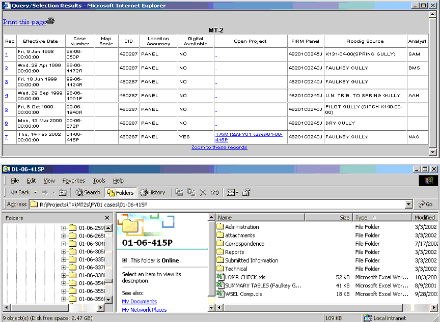
The overall development of MAP DIGR is focused on making an analyst's job easier. After spending time in the field with analysts and caseworkers and looking at routine activities, PBS&J developers opted to expand the GIS functionality in MAP DIGR to include some innovative functions. In addition to the tools shown here, PBS&J developers expect that other tools will need to be developed as users become accustomed to the overall power and versatility of the system. Select by Line/Polygon Tool With this tool, the user can select features in the active layer by drawing a line or polygon. A polygon or line allows the user to create more tailored selections than are possible using the "out-of-the-box" rectangle selection tool. For example, an unnamed stream reach (rather than an entire stream) can be selected using the polygon tool. This selection can then be buffered to determine how many LOMA cases occur within 200 feet of that section. LOMA and LOMR Links Once a LOMA or LOMR case has been selected, caseworkers can directly link to any scanned copies of any associated documents that reside on the local PBS&J network. This saves analysts time by eliminating the need to fill out library requests to obtain these documents. Currently, more than 1,200 LOMR and 5,500 LOMA cases are linked to digital data. Add x,y Case Tool With this powerful tool, new cases can be entered directly through MAP DIGR. Analysts can add in a new case by locating its x,y coordinates or by searching for its address and enter its case number, vertical datum, elevation, and the analyst's name. This information is tagged with the x,y coordinate and all of the information is then entered into the databases containing LOMA and LOMR cases. Linking to Non-ArcIMS Web Sites Users can link to Web sites that display information based on x,y coordinates such as TerraServer, Tiger Mapping Services, The TopoZone, and Maptech, Inc. When entering a new case in MAP DIGR, the software passes the x,y location onto the other sites. Users can then download the information such as digital orthophoto quadrangles (DOQs), topographic maps, or aerial photographs for that location directly from other Web sites. Analysts searching for resources related to a particular case can also access this information. MAP DIGR at WorkMAP DIGR went online in November 2001 on the PBS&J Intranet within the Beltsville office. PBS&J estimates it has improved customer response from 60 days to approximately 20 days and predicts that response time will decrease further as more digital data is incorporated into the system. The system also allows PBS&J to be proactive in its support of FEMA activities. By using tools such as the stored queries and buffers, caseworkers can flag areas containing several cases located close to a flood source so that FEMA can determine if the area needs to be remapped. MAP DIGR was also an invaluable tool during the flooding disaster in Texas in July 2002. Using MAP DIGR to visualize a wealth of information on the counties that were affected by the flood, PBS&J managers were able to quickly generate a list of the approximate number of FIRMs that would need to be remapped and efficiently estimate the cost of this work. The power of the MAP DIGR search engine has received such positive feedback from analysts and caseworkers that it was released to select FEMA regional staff in April 2002. Plans are now being made to add not only more data to the MAP DIGR, but also to incorporate GIS analysis tools. This will allow for data analysis without GIS software on the client machine. In addition to enhancing customer service, improved map management and data sharing should have far-reaching effects in reducing flood losses in the future. As the need for accurate and easily accessible flood hazard data increases, quick access to flood hazard information that MAP DIGR allows could be invaluable. Eventually developers, water resources and floodplain managers, and emergency and first responders will be able to benefit from applications such as MAP DIGR. For additional information on FEMA or the Map Modernization Program, please visit http://www.fema.gov. For more information about MAP DIGR, please contact
12101 Indian Creek Court Beltsville, MD 20705 Tel.: 800-697-7275 About the AuthorsCarrie Smith is a GIS analyst with PBS&J's Information Solutions Division. Prior to joining PBS&J, she received a bachelor's degree in biology with a minor in marine science from Pennsylvania State University. Subsequently, she was a graduate research assistant at the University of Georgia where she received a master's degree in marine science. Joshua Price is a senior GIS analyst at PBS&J for the National Flood Insurance Program. |