October - December 2002
October - December 2002 |
||||||||
|
|
||||||||
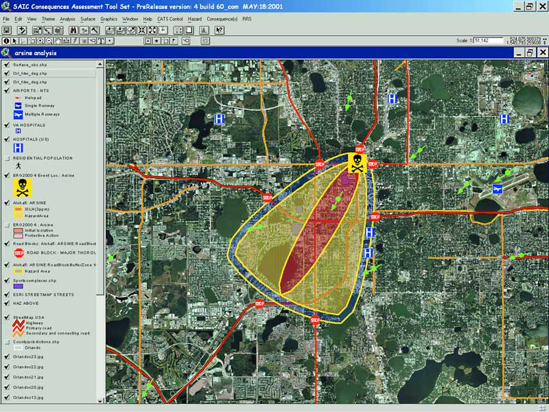
As one of the most popular tourist destinations in the United States, Orlando, Florida, draws more than 40 million visitors each year to such attractions as Walt Disney World and the Kennedy Space Center. When these visitors--and 194,000 commuters--are added to its resident population of 185,915, there can be a large number of people in the 104 square miles of metro Orlando at any one time. With this kind of population density, effective public safety is of paramount importance. The ChallengePrior to November 2001, fire and police communications for the City of Orlando were housed in the Emergency Operations Center (EOC). In November 2001, the fire communications operation, followed in January 2002 by police communications, moved into a new, state-of-the-art facility called the Orlando Operations Center (OOC), which replaced the EOC as Orlando's emergency preparedness and public safety hub. One of the most advanced centers of its kind in the United States, the OOC features advanced emergency operation capabilities and is designed and constructed to withstand a Category Three hurricane [a storm with winds of 110 to 130 mph and a storm surge of 9 to 12 feet above normal]. It's one thing to be prepared for unexpected severe storms--it's another to have to respond to threats from bioterrorist attacks or industrial accidents that send toxic materials airborne. Previously, the City of Orlando relied on information from the National Weather Service that was too generalized for localized emergency management support. OOC decision makers looked to Meteorlogix's experience in displaying weather data, providing alert services, and integrating weather data with GIS for the emergency weather management capabilities they needed. GIS-Based Weather Decision Support SystemWorking closely with the City of Orlando, Esri business partner Meteorlogix developed the MxInsight MetroWatch solution built from an integrated suite of GIS-based weather decision support system components that work seamlessly with the Consequences Assessment Tool Set (CATS) software from Science Applications International Corporation (SAIC). With MxInsight MetroWatch, City of Orlando emergency management personnel have instantaneous access to dynamic, hyper-local weather conditions that help them dramatically improve public safety responsiveness to severe weather situations as well as biohazards and chemical threats. According to Orlando Mayor Glenda Hood, "Meteorlogix is defining the future of emergency weather management with this product." Local, Current Weather for the Entire CityNational Weather Service weather observations, taken at the airport which is distant from the City center, do not reflect urban weather conditions. In addition, observations are not reported frequently enough for timely decision support. The City of Orlando addressed this issue by establishing an Orlando weather network of 14 real-time local weather observation monitoring systems strategically distributed throughout the City. An additional mobile weather station, deployed with the City's heavy rescue and hazardous materials unit, provides critical on-site weather data at the scene of major incidents. Data from the Orlando weather network is streamed to an MxInsight Metwork GIS system at the OOC. Metwork GIS uses proprietary and Esri run-time components to operationally convert the data into a new shapefile every minute so that observations can be included in City-wide decision making. Seamless Integration With CATSWeather-enabled plume modeling tools provide City agencies with critical information to respond appropriately to airborne terrorist and industrial chemical situations. SAIC and Meteorlogix jointly developed an extension to CATS that allows users to access Meteorlogix weather for input into CATS analysis models. In the event of airborne toxic materials, local weather information is automatically accessed and seamlessly integrated into CATS-constituent plume models for hazard analysis by emergency services personnel. This provides emergency responders and managers with the ability to model the release and track the future positions and concentrations of hazardous chemicals or airborne biological agents. This enables managers to properly place roadblocks, mobilize the closest public safety resources, and deploy medical resources necessary for a sustained response to a hazardous incident. Continued on page 2 |