In recent years, the roles of emergency managers, first responders, and homeland security experts have become increasingly difficult as the result of new and sometimes unpredictable threats to the security of the public and critical infrastructure.
GIS technology has been used for emergency decision making and crisis management. By combining GIS and Internet technologies, Esri now provides emergency management and homeland security personnel with new capabilities for emergency response management as a Web service called ArcWeb Homeland Security.
ArcWeb Services from Esri offer a way to include GIS content and capabilities in Internet and/or Intranet applications without having to host data or develop applications. This results in significant savings in time, expense, and computer resources. With ArcWeb Services, spatial data and GIS functionality can be delivered to ArcGIS as well as custom Web applications.
ArcWeb Homeland Security will provide access to current, high-quality geographic information through a secure Internet application service. This Web service provides high-resolution imagery, street data, and other critical geographic data for the areas of responsibility of government agencies; is easy to use; and is readily accessible through an Internet browser. Emergency managers can view emergency incidents and events across their community and surrounding areas and can create highly detailed views of critical infrastructure or other vital facilities. Geographic data is enhanced with real-time views of current and emerging weather conditions.
To effectively manage emergencies and threats, agencies must maintain the current status of critical assets. Understanding potential threats, current incidents, and the status of public safety resources, both personnel and equipment are vital for a comprehensive public safety program. These queries are best answered by a map that tells what is happening and where it is happening.
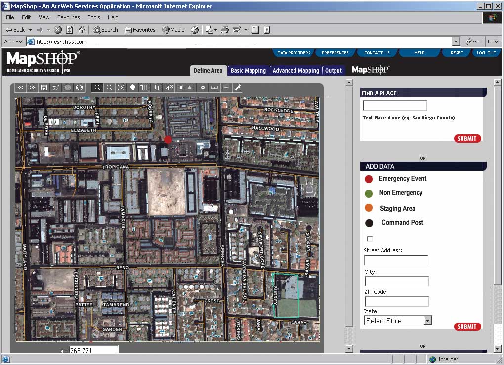
ArcWeb maps provide a truly dynamic common operating picture (COP) for homeland security officials and emergency managers. What is a COP? It is a map of an area that can illustrate
- Where are critical assets located?
- Are these assets threatened?
- Where should security be increased?
- Where should emergency management and public safety resources be located?
These maps track what current emergencies and/or events are occurring and the overall status of a situation. To manage effectively, emergency management and homeland security personnel must understand these issues. As the situation changes, the COP is updated to reflect the current situation.
COP must display activities at local, regional, and national levels. An event may be limited to a single facility, a small section of a community, or a region or may involve an entire state.
Whatever the scope of the emergency, managers must be able to see data for the geographic area involved and related information. The same requirements for military planning and operations also apply to homeland security and emergency management. Potential targets, asset locations, potential threats and status, and the capability of response resources must all be understood.
Familiarity with GIS should not be a prerequisite. As events or incidents are posted on the map, additional information, delivered as text, is available. Users can access this data by clicking on the event or incident on the map. Access to a COP by key government officials is also necessary. Officials in various departments who are responsible for vital input on emergency decisions should be able to access data immediately from any location via an Internet connection.
A COP must provide an incident management view of the affected area. A detailed map showing buildings, infrastructure, exposures, and other assets affected by the emergency is critical to emergency management decision makers. Work assignments, priority areas, and other required actions are identified and communicated through maps.
Keeping the public informed during a crisis is also important. Updated event information that is available to the public saves staff time. Information important to the public can answer questions such as
- Where are road closures?
- Where are evacuation shelters?
- Where is the power out?
This information can be visually created and published for the print media or can be posted to a public Web site.
Because ArcWeb Homeland Security can be provided as a hosted Web application, it can be used to distribute information without requiring much in the way of resources from a government agency or organization. It provides a wealth of current geographic data that supplies a geographic view of a single facility, a local area, a region, or a view of the entire country. Map data from addressable streets to dynamic weather data can be added. Map datasets include complete United States streets, demographics, topographic data, imagery, and points of interest including schools and hospitals.
As events or incidents are posted to the map, populating a simple form can provide additional detailed information. This new information is stored in the database and is associated with a specific event or incident. Clicking on the event point will display this information.
Any government agency can subscribe to ArcWeb Homeland Security. Very little training and no additional software or hardware, beyond a computer with an Internet connection and Web browser, is required. Consequently, information technology departments are minimally affected.
Users can access high-quality, current data that is maintained 24 hours a day, seven days a week. Desired map views can be quickly printed and easily distributed. ArcWeb Homeland Security is a cost-effective solution for homeland security and emergency managers that provides access to rich static and dynamic data sources of the area or region of concern and allows for remote access through a password-protected Web browser. For more information, visit www.esri.com/arcweb.