October - December 2003
October - December 2003 |
||||||||
|
|
||||||||
The events of September 11, 2001, triggered the current critical examination of institutional information systems. Questions about the quality, kind, and availability of mission critical data and the ability of organizations to generate and communicate information have come under discussion. The level of preparedness and the ability of the health community, particularly hospitals, to respond to unexpected large-scale events also remain topics of considerable interest. Geospatial intelligence, embedded in hospital information systems (HIS), provides a framework for managing, integrating, analyzing, and communicating volumes of data so that hospitals can respond quickly to disease outbreaks, whether naturally occurring epidemics, bioterrorist events, or other large-scale medical events. The Role of Hospitals and Health SystemsHospitals and health systems have a tremendous stake in a community's preparedness. Because the majority of hospitals are operated or owned by health systems, most personnel and medical assets (e.g., facilities, medical professionals, ancillary resources) are geographically distributed across jurisdictional boundaries. Although hospitals and health systems typically operate complex, robust, and around-the-clock information systems, they have not spent sufficient resources developing information systems that are capable of geographically integrating externally acquired information with internally generated information. In addition, hospitals are seldom prepared to exploit information they possess to adequately prepare for an unexpected large-scale medical event. What Preparedness MeansUnlike the utility company that can (and must) determine the locations of customers affected by a power outage, a hospital has little or no ability to locate its patients or staff in relation to an area affected by an event such as a chemical release or disease outbreak. A health care facility's employees and medical facilities are its greatest assets. Optimal redeployment of these resources during an emergency is critical to a community's overall response. Consequently, a health provider's commitment to patient safety can mean protection beyond the physical walls of the health facility. Goals of Hospital PreparednessPreparedness requires the development of a set of automated processes that can be easily incorporated into mainstream operations. These processes should provide hospital management with
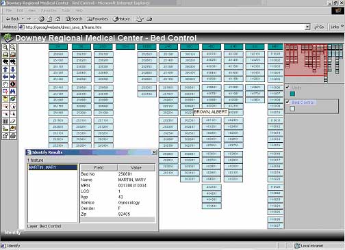
Current CapabilitiesIn terms of mission, organization, workforce diversity, and governmental accountability, community hospitals have unique and information-intensive requirements. While hospitals are fairly adept at scaling up for a predictable event, most hospitals are not well prepared to respond to an unexpected large-scale event such as an epidemic, the release of a biological agent, or a terrorist attack. The ability to dedicate resources—from staff to medicines—in response to a large event has been seriously compromised in recent decades. For budgetary reasons, a concerted effort to reduce "excess" capacities, whether in staff, beds, or supplies, has compromised the ability of hospitals to respond at this level. Evidence of this concern was expressed by Dr. Julie Gerberding, director for the Centers of Disease Control and Prevention. In testimony before a subcommittee of the United States Congress in May 2003 relating to the outbreak of Severe Acute Respiratory Syndrome (SARS), she stressed that both sustained efforts and prepared public health responses will be necessary to deal with the threat of emerging infectious diseases. "The weakest link in the public health structure could allow spread of this disease," she said. Equally alarming was the publication of the results of a survey by Hospitals & Health Networks magazine. In 2002, 800 hospitals participated in the "100 Most Wired Hospitals and Health Systems in the United States." This survey, which is regarded as a benchmark tool for measuring information technology effectiveness, showed that of the 100 most wired hospitals, only 26 percent were utilizing a fully electronic approach to disease surveillance. Leveraging HIS for PreparednessMany national leaders are now asking hospitals to strengthen information systems and provide more timely and critical information to decision makers in emergencies. This has led to the development of command centers or health care situation rooms (HSRs). An HSR is a dedicated resource, either mobile or fixed, that is equipped with computers, data servers, data storage devices, and large format printers and can access, manage, and disseminate critical information regardless of its physical storage location or institutional ownership. Fundamentally, HSRs provide a view of the community with geographical exactness. Visualized informatics, made possible by the use of GIS, provide critical asset information such as the location of health facilities and personnel, transportation networks, and environmental conditions. An HSR provides information essential for optimal redeployment of a hospital's workforce and movable assets in response to an emergency. In addition to the Department of Health and Human Services (DHHS) command center in Washington, D.C., the Centers for Disease Control and Prevention is also using GIS at its command center in Atlanta, Georgia. Analytical, GIS-enabled software integrates disparate information and visually displays the scope of events such as floods, fires, hurricanes, tornadoes, storm surges, and biological and chemical hazards. Event modeling software, such as the Consequence Assessment Tool Set (CATS), helps determine where and how to respond. CATS, a product of Esri business partner Science Applications International Corporation (SAIC), is currently in use in the DHHS command center. CATS helps decision makers quickly assess affected populations to accurately predict needs and locate resources for sustained response. Continued on page 2 |