October - December 2003
October - December 2003 |
||||||||
|
|
||||||||
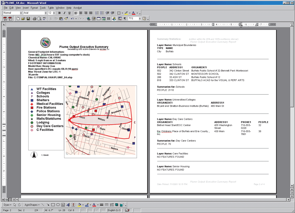
It represents an area where, with 95 percent probability, LOC values will be exceeded. The broken "uncertainty lines" that demarcate the larger zone represent potential changes in wind direction that might affect the direction, size, or shape of the plume. The application processes each of these shapes into a single shapefile with attribute values for each of the two polygons being automatically generated. Once the shapefile is created, it is projected into the coordinate system defined by the user. The projected shapefile is then added to the current view in ArcView. A unique classification scheme based on either of the two confidence category values is applied from a legend (.avl) file. Processing takes 20 to 30 seconds. Reporting the ResultsIf the user wishes to create summary reports, a spatial overlay query is run in which the plume created by the application is overlaid against all the shapefile sources defined in the OSR configuration. Attribute values of entities that are found within the plume are then reported to the user. The resultant report file is saved as a Microsoft Word file. The report also includes information about the footprint such as time, location, chemical type, model run, user-specified LOC, maximum threat zone, and a footprint map. Regenerating Additional PlumesThe program, which can produce numerous plumes and OSRs in real time, does not require restarting to create a new plume. For example, if an atmospheric parameter such as wind speed changes, the user can regenerate the footprint in ALOHA, and the county's ALOHA extension can easily regenerate a plume and OSR from the new parameters. Future EnhancementsFuture versions of the application may go in any of several directions. Two possible directions are Web integration with ArcIMS and the addition of routing capability. Web integration with ArcIMS—The application could be enhanced to place a copy of an output plume in a directory that could be read by an ArcIMS service. This would provide critical information more efficiently to a wider audience for emergency notification applications. Concurrent with the creation of the plume shapefile, the output summary report could be created in an HTML/Web-readable format for ease of use on an Internet/Intranet platform. Routing capability—If integrated with network routing software, the application could be developed to provide emergency responders with routing information to handle numerous scenarios such as avoiding a contaminated area, deciding which streets to close, and designating alternate routes for evacuation to shelters. SummaryGIS has become an essential tool in emergency response planning and in enabling decision makers to manage a crisis situation effectively. Having accurate information on areas impacted or potentially impacted by a disaster, such as the release of a hazardous gas, helps ensure the proper utilization of critical resources. By integrating applications designed for specific disaster scenarios with customizable GIS technology and real-time data, planners can be much better prepared for these scenarios than they have been in the past. For more information, contact Brian Tomaszewski, Senior GIS Analyst/Programmer ReferencesCAMEO Home Page: www.epa.gov/ceppo/cameo/index.htm ALOHA Online Manual (PDF format): www.epa.gov/ceppo/cameo/pubs/aloha.pdf Erie County Mapping Services: AcknowledgmentsThe author thanks Dale Morris, director of the Erie County Department of Environment and Planning, Office of Geographic Information Services for helping make this project possible. He thanks Leigh Whyte, Kevin Siepel, and Lana Khitrik of URS for their assistance in preparing this project summary. About the AuthorBrian Tomaszewski is a senior GIS analyst/programmer with URS Corporation's Buffalo, New York, office. He served as lead programmer and designer of the described application and is pursuing a master's degree in geography/GIS at the State University of New York at Buffalo. He may be reached at Brian_Tomaszewski@urscorp.com. |