October - December 2003
October - December 2003 |
||||||||
|
|
||||||||
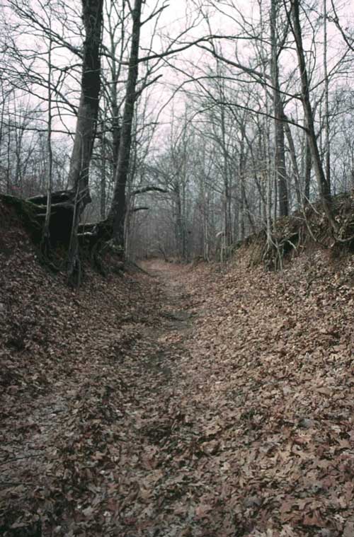
During the latter part of the 1830s, the United States government, pursuant to the Indian Removal Act of 1830, forcibly relocated more than 16,000 Cherokee Indian people from their homelands in Tennessee, Alabama, North Carolina, and Georgia to the Indian Territory that is today known as Oklahoma. The impact was devastating—hundreds of Cherokee people died during this forced migration, and thousands more perished from the consequences of the relocation. This tragic chapter in American and Cherokee history became known as the Trail of Tears. The Trail of Tears National Historic Trail, administered by the National Park Service in partnership with federal, state, and local agencies; nonprofit organizations; and private landowners, commemorates the Cherokee experience. It identifies the routes that 17 Cherokee detachments followed westward. Today the trail encompasses approximately 2,200 miles of land and water routes and traverses portions of nine states. The Arkansas Historic Preservation Program (AHPP) is working with the National Park Service and the Trail of Tears Association, as well as with state historic preservation offices in other states, to identify and preserve properties associated with the Cherokee removal of the 1830s. The traditional method of finding historic features involves a combination of historic records and maps. Using references to locations mentioned in original sources helps researchers locate historic features on maps, whether modern or historic. However, problems arise when identifying features located between the known points. Although historic maps show areas between reference points, in practice this only limits the search radius to several miles. Even with the assistance of volunteers, locating a 170-year-old feature in an area this size can be difficult, if not impossible. To help identify sections where the route is unclear, AHPP has established a GIS. Information from historic maps, photographic imagery, and elevation data has helped researchers uncover some lost sections of the Trail of Tears. Other data sources include digital orthophoto quadrangles (DOQs), georeferenced historic maps, and historic databases. AHPP is using ArcGIS with the ArcGIS Spatial Analyst and 3D Analyst extensions, ArcPad with a GPS receiver, and 3D visualization. Historic maps—one of the oldest research tools—have proven to be the most useful. Historic maps show how an area developed, identify where historic events took place, and sometimes even illustrate the character of the landscape. Modern and historic maps can be used together to help historians decide where to survey for historic or archaeological resources or where to create historic easements. Georeferencing these maps not only narrows the search but can often pinpoint the objective. A georeferenced map can be overlaid with modern maps or loaded into a GPS receiver. The AHPP uses both methods in research. However, in the field, historic maps in a GPS receiver have been unsurpassed in achieving results. The accuracy of 140-year-old hand-drawn maps can be surprisingly good even though accuracy wasn't always the highest priority of the cartographers who made them. On several occasions, georeferenced maps displayed in a GPS unit have led researchers to within 10 feet of the desired feature. Georeferencing an historic map that was not based on a public land survey system or known boundary is challenging. Determining the proper scale and correct orientation of the map presents other concerns. Several methods have been used to georeference these maps. Checking for structures and comparing them with the AHPP's historic structure database is one method. Another method is to search for place names. Difficult cases may require using mountains and rivers as reference points. Because rivers meander, they are generally not good for referencing unless a georeferenced map from the same period and general area is available. Alternatively, digital elevation model (DEM) data can be used to produce hillshade maps that make the previous courses of the river visible. Even a poorly georeferenced map can limit the search area. Overlaying a georeferenced map with a color infrared digital orthophoto occasionally highlights the feature being sought. Infrared reflectance often reveals old roadbed as long as there isn't too much tree cover. GIS has helped AHPP find and record numerous sections of the Trail of Tears. Once these sections are verified and their locations recorded as GPS coordinates, this information will be sent to the National Park Service. Hopefully, AHPP's work will help interpret and improve the Trail of Tears National Historic Trail. In addition to work documenting the Trail of Tears, the techniques and historic maps collected by AHPP will aid in future historic features research, cultural resource management, and the review of the impact of federal projects as required under Section 106 of the National Historic Preservation Act. For more information, contact Jim Files, GIS Coordinator |