GISCorps Hurricane Response
On August 30, 2005, an urgent request for assistance was received through the Esri Hurricane Support 2005 Web site. It was forwarded to GISCorps director Shoreh Elhami. The requester, Talbot Brooks, needed help supporting critical search and rescue operations for Hurricane Katrina.
A Category 5 hurricane, Katrina had slammed the Gulf region of the United States the day before, causing major damage to Louisiana, Mississippi, and Alabama and displacing more than one million people. Early estimates place dollar losses attributed to Hurricane Katrina at more than $200 billion, exceeding those caused by Hurricane Andrew in 1992.
At the time he asked for help, Brooks was working at the Mississippi Emergency Operations Center (EOC) in Jackson. Brooks, director of the Center for Interdisciplinary Geospatial Information Technologies at Delta State University in Cleveland, Mississippi, had headed to Jackson two days before Hurricane Katrina made landfall in Louisiana.
Brooks wanted volunteers whose GIS skills included map production, analysis, and data management. He also needed volunteers with GPS proficiency and experience in disaster management.
Overwhelming Response
At the time Elhami got Brooks' request, the GISCorps had 270 voluneers in its database. Requests posted on the Urban and Regional Information Systems Association (URISA) and GISCorps list serves triggered a massive response. By September 3, 500 more GIS professionals had been added to the database.
"The response of the community was just amazing, and I was humbled by that every moment of the day," said Elhami. As of this writing, more than 900 GIS professionals are ready to help with both projects and emergencies.
Within 48 hours of being contacted by GISCorps, volunteers from the first deployment were headed to Mississippi to join volunteers from the Geospatial Information & Technology Association (GITA), various Mississippi agencies, the state education system, and other organizations that were converging on the state. The GISCorps' first deployment consisted of 20 volunteers from across the United States-Ohio, Missouri, Florida, North Carolina, Illinois, California, New York, Texas, Arkansas, and Colorado. Drawn from both the public and private sector, they averaged eight years of GIS experience.
Modeling Storm Effects
Before volunteers from GISCorps and other agencies and organizations began arriving at Jackson EOC, Dr. Chris Mullens from the University of Mississippi produced initial wind and damage estimates for Hurricane Katrina using HAZUS-MH, a risk assessment program for analyzing potential losses from floods, hurricanes, and earthquakes developed by the Federal Emergency Management Agency (FEMA). HAZUS-MH uses ArcGIS to map and display hazard data. This data includes estimates of economic loss and the impact of natural disasters on populations and the built environment.
Mullens' work, along with storm surge modeling done by Brooks, helped managers, before the event, place response resources as close as possible to areas likely to be affected while ensuring the safety of responders. See an accompanying article, "Predicting Hurricane Katrina's Storm Surge Using ArcScene," for more information on Brooks' work.
Coordinates Aid Rescue Efforts
While resources were being assembled at the Jackson EOC, Brooks used GIS to help search and rescue efforts. He translated addresses into GPS coordinates that guided United States Coast Guard rescue missions to storm victims in neighborhoods that no longer had streets or street signs.

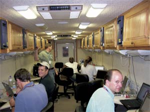 |
| The Mississippi Global Education Mobile, also known as the Brain Bus, was borrowed from Mississippi State University and used by volunteers around the clock for managing and analyzing data and producing a variety of map products. |
Using the MSN Mapblast Web site to display a geocoded location, Brooks found the address location using available transportation network data in ArcMap. In ArcMap, he translated the location into latitude and longitude coordinates for Coast Guard helicopter missions.
When the Internet connection was down, Brooks used the measure tool in ArcMap to approximate address locations by assuming a standard distance between houses to calculate house locations because "something was better than nothing."
The street network data initially available was difficult to work with for those not familiar with the area. Many road segments lacked meaningful labels (or sometimes any labels) so labels were omitted from some of the first maps. Lack of address ranges for street data and fields that combined the street name with a variety of suffixes made the data difficult to use.
Later, volunteers working at Jackson EOC located stranded residents based on descriptions such as "I'm trapped in a water treatment plant" using available vector and imagery data. Coordinates were generated and radioed to helicopter crews.
After several days, volunteers obtained access to much better data-Tele Atlas/TomTom street data for geocoding, detailed street maps in PDF format from the Mississippi Department of Transportation, commercially produced parcel data, and building footprints for key Mississippi counties.
Early Mapping Efforts
Because rescue teams had not yet been assigned to areas, initial maps for responders had to show all 70 miles of the Mississippi coastline. At this scale, the value of labeling was limited. However, the addition of a one-mile-square graticule with longitude and latitude coordinates made these maps useful for helicopter pilots. Approximately 120 of these maps were printed and laminated.
More Help Arrives
The first GISCorps team that arrived in Jackson worked on map production in the Mississippi Global Education Mobile, a mobile home that had been converted into a classroom for teaching computer classes. Also known as the Brain Bus, it had been recruited from Mississippi State University. Its 12 workstations were kept busy around the clock with volunteers who organized data, performed analysis, and made a variety of map products that helped rescuers, managers, government officials, and the public.
As part of the first GISCorps deployment, a second team of GPS specialists, who supported search and rescue personnel in the field, arrived in Jackson.
Continued on page 2
|