ArcUser Online
Making the Leap (easier)
Support from online communities smooths move from ArcIMS to ArcGIS Server
By Matthew DeMeritt, Esri Writer
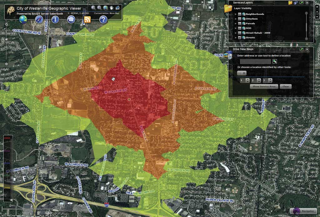
Westerville Flex viewer displaying the Drive Time Ring widget
This article as a PDF.
Before the advent of Internet map servers, most maps were requested over the phone. GIS departments took individual requests from internal customers, then processed, printed, and shipped those orders. When Esri released ArcIMS 10 years ago, that cumbersome process became obsolete. Using a Web browser, customers themselves could access ArcIMS maps, turn layers on and off, and query features to obtain attribute information from the server.
Within a few years, enabling technologies—such as broadband and map caching—allowed maps to be served more quickly. User expectations for both consumer and business mapping applications increased. In 2007, Esri released a new system called ArcGIS Server that harnessed those advances and gave organizations the ability to serve dynamic, fast-rendering maps.
Meeting Increasing Demands
In Westerville, Ohio, ArcIMS had been used almost exclusively by internal users for almost a decade. The planning and development and police departments frequently accessed zoning information, address points, parcels, and aerial photography from the site. A public-facing site let citizens view simple layers. When Brian Nemec came on board in 2008 as GIS manager at Westerville, his first objective was to configure ArcIMS to accommodate a growing clientele that wanted greater access to geographic information.
"I hadn't worked with ArcIMS before, so I knew there was going to be a steep learning curve," said Nemec, who was working on a master's degree in engineering in GIS from the University of Colorado at Denver (UC Denver) at the same time. His coursework included a class dedicated to Web GIS technologies taught by Greg Gunther. In this class, Nemec learned about ArcGIS Server.
About that same time, internal users at Westerville began asking for the same kind of functionality that consumer mapping services, such as Microsoft's Virtual Earth (now Bing Maps), provided. Although Nemec could have coded some of those functions into ArcIMS, this growing clamor for new functionality threatened to outpace whatever progress he made. "The tools everyone wanted were already available in ArcGIS Server, so it didn't really make fiscal sense to bolt on these improvements one at a time to keep up with department user demand." For Westerville's needs, ArcIMS no longer fit the bill.
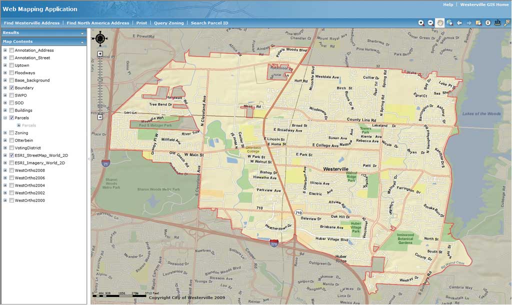
A sample application that Nemec used to demonstrate the capabilities of ArcGIS Server
Nemec requested an upgrade to a more robust server that could grow with the expanding user base. With experience he gained from his Web GIS class at UC Denver, he set about creating a JavaScript-based site that mirrored the functionality of the ArcIMS Web site with a few additions. He presented the application to Westerville management. "The speed, performance, and added content in that application persuaded Westerville management that it was a smart decision," he noted.
Getting Under Way
Before getting started, Nemec visited a variety of online communities to familiarize himself with the issues associated with the transition from ArcIMS to ArcGIS Server. Because he was most comfortable with JavaScript, he initially tapped the experience of the JavaScript community. He found the sample maps and applications he needed to start creating the site. "I quickly learned from these online resources that I didn't need to be a programmer to make a fully functional GIS Web site. After that revelation, the transition became a lot more doable and far less intimidating."
Nemec began the project by taking working samples from the community and integrating his own data into them. He tinkered with the samples to see what did what. Lifting chunks of code from one example and copying and pasting them into his working sample, Nemec slowly breathed life into the application. "I did the same thing with other samples, copying here and pasting there," he said. "When it got tricky, I simply went to the communities for help and quickly got everything in the right position doing what it was supposed to do." Support sites contained more than enough working samples and coding advice to guide Nemec through the process.
When Esri released ArcGIS API for Flex in 2008, Nemec continued the same process, taking what he liked from samples and methodically piecing the application together. It was a good system to build the framework of the site, but Nemec knew he'd also want functionality that wasn't available in the samples. "Fortunately, working with the samples familiarized me with the code enough to experiment with it and customize it," said Nemec. "It wasn't long before I started using Python and other scripting languages to automate tasks on the server."
Crucial Need for Querying
Before moving to ArcGIS Server, Westerville had wanted to give its expanded user base not only fast mapping but also the ability to perform advanced queries. Although Nemec could plot points in ArcIMS, he could not dynamically create statements that would review data for a specific number of days and return results. "We needed that for our police site," Nemec said. "Temporal data is crucial for law enforcement to create statistics and serve them to the public." With ArcGIS Server, Westerville citizens can now get specific crime reports through its Flex-based police site.
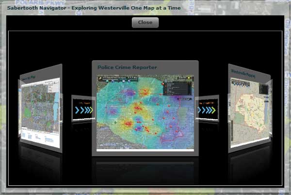
Nemec designed this carousel navigator widget. Users can spin to a different map without having to leave the current map.
ArcIMS was limited to performing only simple queries on parcel information. Westerville needed to deliver more than zoning boundaries on the map. It needed to return data, such as hyperlinks, parcel IDs, and owner information, in response to queries of the county auditor Web sites. Using ArcGIS Server, Nemec can hyperlink to actual ordinance codes over the Web. "Builders, contractors, and landowners can now easily access the current zoning ordinance for a property," said Nemec. "They no longer have to come into the planning and development office for possible zoning change requests."
Start to Finish
Westerville's ArcGIS Server site took Nemec about six weeks to get running and online. After that, the time required for tweaks and improvements shortened significantly as he became familiar with the code and was able to recycle some of his existing code. "The great thing about ArcGIS Server is that I didn't have to be a programmer to create my Web sites." For Nemec, "The ArcGIS Server and code communities were an invaluable repository of knowledge, walking me through what could have easily been an overwhelming experience."
Nemec quickly discovered that Esri support services and user communities make the ArcIMS-to-ArcGIS Server transition simpler than he thought possible. Now Westerville not only meets user performance expectations but can serve the demands of a larger user base thanks to ArcGIS Server's cached map services, optimized map services, and lightweight APIs. For more information, contact Brian Nemec at brian.nemec@westerville.org.