ArcUser Online
The Best of Both Worlds
Conference for the GIS education community
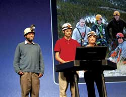
High school students Tia Bakker and Ernie Cottle from Bigfork, Montana, described their work using GIS for mapping, monitoring, and conserving resources in caves in Glacier National Park during the Plenary Session.
This article as a PDF.
In its 10th year, the Esri Education User Conference (EdUC) continues to bring educators together to learn from each other in an intimate setting while giving them an opportunity to interact with the larger GIS community. This was possible because EdUC was held July 10�13, 2010, in conjunction with the Esri International User Conference (Esri UC) in San Diego, California, at the San Diego Convention Center.
EdUC is the premier event for educators who are passionate about employing GIS to improve teaching and research. At the conference, members of the education community shared ideas and experiences about what matters to them most through presentations, special interest group meetings, and workshops.
A hot topic this year was the use of GIS to promote analytical and critical thinking skills—the higher-order problem-solving skills employers say they want in future employees. Plenary Session presenter Gilbert M. Grosvenor underlined the importance of promoting these skills. "Imagine what changes we could make together in communities across the country and around the world if all geoprofessionals here and those you know would work with local educators to bring that power to our youth," said Grosvenor, who is chairman of the board of the National Geographic Society and former Esri Lifetime Achievement Award recipient.
The 2010 EdUC marked the one-year anniversary of the GeoMentor program, a global answer to the growing need for geoliteracy. In the year since this program was initiated, it has proved successful in bringing technical expertise by promoting core science, technology, engineering, and mathematics (STEM) content in the classroom. GIS has proved an engaging tool that allows students to use real-world data to solve real-world problems.
The success of this program was demonstrated during the Esri UC Plenary Session when high school students Tia Bakker and Ernie Cottle from Bigfork, Montana, described their work using GIS for mapping, monitoring, and conserving resources in caves in Glacier National Park. The two are part of the Bigfork High School Cave Club, adopted by local GIS professionals as part of the GeoMentor program. This has allowed club members to approach their explorations from a more scientific and analytic point of view.
Other key topics at EdUC included the use of GIS for administration purposes in educational institutions, the process and impact of implementing ArcGIS Server in the teaching environment, and the potential for making greater use of resources available from ArcGIS Online. EdUC attendees worked with the new ArcGIS 10 release in the Hands-on Learning Lab and in computer workshops led by Esri instructors.
Dr. Mark Chandler, international director of research for the Earthwatch Institute, was this year's keynote speaker. A prominent conservation biologist with more than 20 years of experience conducting field research throughout the world, Chandler's speech was entitled Using Citizen Science and GIS Technology to Connect the Local to the Global.
The first Making a Difference in Education Award was presented to Dr. Mugheer Khamis Al Khaili, director general of the Abu Dhabi Education Council (ADEC). This award was given in recognition of ADEC's special contributions to GIS in education through implementation of an enterprise-wide GIS that exemplifies how GIS can be extended across the educational system.
In accepting the award, Al Khaili said, "It is a great honor for both me and the ADEC to be recognized by Esri for our efforts in the implementation of GIS technology throughout our country's entire educational system. This is particularly important to us as we transition from a petroleum-based economy to one that is knowledge based. �Education First' is our call to action in Abu Dhabi. The Making a Difference in Education Award from Esri is a tribute not only to the dedicated staff at the ADEC but to our entire country and provides us with a great incentive to continue our work."
The award for Esri Development Center (EDC) Best Student for 2010 was given to Jeremy Moore, a graduate student at the University of Minnesota (UMN), for developing ArcGIS Server applications for the Colorado Avalanche Information Center and for facilities management on the UMN campus. His work was chosen from other nominated GIS projects completed by students at the 30 international universities participating in this selective program.
EdUC continues as a venue for bringing the education community together and supporting its goal of helping students understand why geography matters. In the words of Grosvenor, "Working together, GeoMentors and educators can help young people comprehend the many layers of our world, see how they tie together, and explore options for a brighter tomorrow."