ArcUser Online
Taking Geography to the Next Level
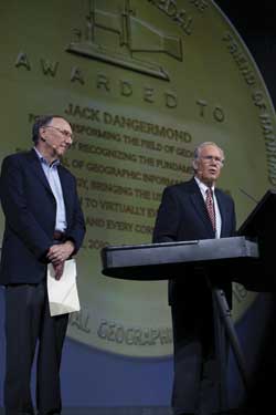
During the Plenary Session, National Geographic Society chairman Gilbert M. Grosvenor (right) presented the prestigious National Geographic Society's Alexander Graham Bell Medal for extraordinary achievement in geographic research to Esri President Jack Dangermond (left) and Dr. Roger Tomlinson (not pictured).
This article as a PDF.
"Is it possible that geospatial consciousness will be a global phenomenon, like the Internet?" asked Esri president Jack Dangermond of attendees of the 30th Annual Esri International User Conference (Esri UC).
GIS users from 6,000 organizations in 134 countries participated in the world's largest GIS event, held July 12�15, 2010, in San Diego, California. The presentations and demonstrations made during the opening day and throughout the four-day conference argued that the answer to Dangermond's question is yes. That vision was encapsulated in the conference's theme, Geography—Opening the World to Everyone.
Dangermond sees a world in which everyone can take advantage of GIS, contributing and using geographic information in ways that will transform geography and open up "our world to new forms of exploration, not simply mountaintops but understanding our world in different ways."
The release of ArcGIS 10, announced at the conference, is an essential factor in this evolution. ArcGIS 10 is a complete system for geographic information that is easier to use and more powerful. A pervasive GIS in the cloud, the office, and the field, it is a strong scientific platform for time awareness, advanced spatial analysis, integrated scientific programming, and 3D GIS. To view videos demonstrating ArcGIS Online, ArcGIS.com, community maps, ArcGIS for iOS, productivity in ArcGIS 10, the integration of Python scripting, imagery, GIS processing integration, ArcGIS Network Analyst, and analysis using 3D and new space and time enhancements, visit www.esri.com/uc.
In addition to presentations and demonstrations of ArcGIS 10, the Plenary Session was an occasion for honoring members of the GIS community for their contributions. Antonio Carlos Salm�n Gonzalez, Mexican cartographer and visionary, received the Lifetime Achievement in GIS Award from Dangermond. "GIS provides the enlightenment and awareness necessary to stimulate the urgent changes needed in Mexico so that its citizens can realize their full potential," he said when accepting the award. He has spent nearly 40 years developing mapping projects in Mexico and abroad.
GIS users from 6,000 organizations in 134 countries participated in the world's largest GIS event, held July 12�15, 2010, in San Diego, California.
Later in the session, Dangermond and Dr. Roger Tomlinson, known as the "father of GIS," each received the prestigious National Geographic Society's Alexander Graham Bell Medal for extraordinary achievement in geographic research. Dangermond and Tomlinson, who have worked together for decades fostering the growth of GIS technology, accepted the awards from National Geographic Society chairman Gilbert M. Grosvenor. The medal has only been awarded once before—in 1980. "I accept this award on behalf of the GIS community—a group of very special people with geographic knowledge who are doing work that makes a difference in our world," said Dangermond.
The conference has traditionally been a venue for recognizing the achievements not only of individuals but also of organizations large and small. The government of Abu Dhabi, United Arab Emirates, received the Making a Difference Award. The Abu Dhabi Systems and Information Centre has built a spatial data infrastructure that facilitates geospatial data sharing among 40 government agencies and other stakeholders. His Excellency Mohammed Ahmed Al Bowardi, secretary-general of the Abu Dhabi Executive Council, accepted the award. The City of Frisco, Texas, population 107,000, was also honored with the Esri President's Award for its outstanding work in improving public safety for its schools through its Situational Awareness For Emergency Response (SAFER) application that provides fire, police, and emergency responders with access to maps and live data feeds while en route to a school incident. The Special Achievement in GIS ceremony, held on July 15, provided another opportunity for highlighting the outstanding work of 140 organizations out of the roughly quarter million that use GIS.
Keynote speaker Richard Saul Wurman shared his "passion to take the journey from nonknowing to knowing" with the audience. The author of 83 books, Wurman may be most well known for starting the TED (Technology/Entertainment/Design) conferences. Among other topics covered during his address, Wurman described his latest trek toward knowing, a project called 19.20.21. He is attempting to understand comparative data on 19 cities that will have 20 million or more inhabitants in the 21st century. The 19.20.21 project was also the subject of one of the featured displays at the conference. To learn more about events at the 2010 Esri UC, visit www.esri.com/ucinsider.