ArcUser Online
"Unconference" Brings Managers Together
Concerns drive agenda at inaugural event
By Monica Pratt, ArcUser Editor
This article as a PDF.
They work for businesses, such as energy companies and consulting firms, as well as an assortment of agencies in local, state, and federal governments and the military.
They come from South America, Europe, Africa, the Middle East, Canada, and across the United States.
Their business cards display a variety of titles beginning with GIS: administrator, director, supervisor, chief, specialist, coordinator, and analyst. Some have titles that don't include the word GIS: information systems manager, geospatial intelligence specialist, or information architect.
Despite the wide range of appellations and origins, the more than 270 participants registered for the inaugural GIS Managers' Open Summit had one thing in common: they were all GIS managers. They are the people who make GIS happen in organizations. And their concerns, challenges, and interests—discussed during the event held on July 13 in conjunction with the 2010 Esri International User Conference in San Diego, California—were remarkably similar.
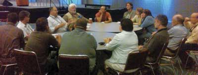
GIS managers discussed their concerns, challenges, and interests during the first GIS Managers Sumit held on July 13 in conjunction with the 2010 Esri International User Conference in San Diego, California
Rather than a traditional conference, the summit was an "unconference." Unconferences have a theme, but event content is determined by those attending. Participants in the GIS Managers' Open Summit volunteered to lead breakout sessions, jotting down topics for each time slot on a white board at the entrance to the ballroom.
Many discussions focused on the challenges of interacting with the larger organization. Selling GIS Services in Your Department was a session led by Russell Vrhovac of the consulting firm Clark Nexsen. "It is hard to convey the value of GIS," said Khaled Hussein, also from Clark Nexsen. Vrhovac said he found regular project presentations were a good way to keep GIS visible in an organization and convey the value it added. Fires in Monterey County, California, in 2007 gave Darryl Tyler's GIS department an opportunity to shine. His department produced information the county "didn't even know it had" and supplied active decision support as well as postevent assessment. Tyler, who began his GIS career working in the field, moved up to a GIS analyst position but never intended to become a manager. However, he has carried out the responsibilities of a GIS manager for Monterey County since 2004.
Managers in this session agreed that one of the biggest challenges related to demonstrating value was building trust relationships in an environment where personal and interdepartmental feuds may have been going on for years. Sometimes these feuds have outlasted the people who started them. "They don't want to work together, but what do they have in common? Geography," observed Vrhovac.
However, without trust, departments will not share their data. Tyler, who led another session entitled Building Trust Relationships, has found a way to deal with this situation. His "Rules of the Sandbox" grew out of the GIS Certification Institute (GISCI) code of ethics. With these rules, "everybody will have reasonable expectations of how their data will be treated."
Trust and data sharing were also themes of other sessions: GIS Data Organization Ownership and Stakeholder Engagement. Demonstrating the value of GIS to the organization and building trust were aspects of sessions entitled Plugging In GIS to Other Departments and Identifying and Delivering Value to Stakeholders.

Russell Vrhovac led one of several sessions that discussed how to communicate the value of GIS to the larger organization.
Other sessions fell into two broad categories: dealing with GIS technology issues and aspects of management specific to GIS departments. Technology issues ranged from managing deployments to cloud computing. GIS-specific topics were concerned with establishing and evaluating performance metrics, enterprise strategies, optimal workflows, and best practices.
Although breakout sessions were the main feature of the summit, two speakers addressed the group. To start off the day, Lew Nelson, Esri law enforcement industry manager, spoke to the group. A former police chief for Redlands, California, Nelson became a GIS manager by "leading a sea of Type As—aggressive Type As, armed Type As."
He was quick to point out the missteps he made on the way to starting a successful GIS program for the department in the 1990s. "When I was telling them what GIS was going to do for them, I forgot to ask what they wanted it to do for them." He urged his audience to remember that GIS is a team sport that requires collaboration to be successful. "Don't assume everyone will see the value of GIS—you need to communicate it to them," he said.
The value of GIS is greatly enhanced when it is implemented across the enterprise. Nelson characterized most organizations as data rich and information poor. The "build once and use many times by many people" enterprise model addresses that problem. Although Nelson observed that creating an enterprise GIS is not an undertaking for the timid, "you have to believe in the power of geospatial data." To be successful, he suggested these strategies:
- Connect with policy makers and technical people in the organization.
- Use a strategic approach but be willing to change tactics to accomplish goals.
- Plan for inclusion.
- Realize that it doesn't get easier as the GIS grows. The corollary is that you must delegate so the GIS can grow.
- Keep them connected.
- Make training a priority.
- Promise conservatively, then over-deliver.
Following the morning breakout session, Ross Smith of PA Consulting Group explained the value and methodology of return on investment (ROI)-based analysis described in The Business Benefits of GIS: An ROI Approach. This Esri Press book, authored David Maguire, Smith, and the summit's organizer, Victoria Kouyoumjian, was furnished to conference attendees.
Attendees had another takeaway from the conference. The summit's goals were to build a community and share information and experiences. This community would address the unique requirements of GIS managers who must understand the technology and recognize how best to apply it while performing classic management functions and overcoming organizational challenges specific to implementing GIS. To continue the discussions that were started in San Diego, a new group, Managers in GIS, has been started on LinkedIn (www.linkedin.com). All summit attendees have been preapproved, but all GIS managers are welcome.