ArcUser
Fall 2012 Edition
The Parcel Fabric Offers Advantages at Any Scale
By Matthew DeMeritt, Esri Writer
This article as a PDF.
The City and County of Denver, Colorado, and Mono County, California—jurisdictions that present a marked contrast in size and staff—have both transitioned to the parcel fabric and now enjoy significantly improved workflows, better management of cadastral data, and a vastly improved editing experience.
In ArcGIS 10, Esri introduced the parcel fabric, a new method for parcel management that helps governments by replacing manual editing of cadastral information with a geospatially integrated data model. The parcel fabric, a composite group layer, manages the spatial and topological relationships inherent in cadastral data. Esri's new parcel data model conforms to a set of rules that continually refine existing parcel data and make land information easier to edit, track, and share throughout the organization and with the public.
Increasing Efficiency on a Large Scale

DenverGIS, Denver's GIS department, received a 2011 Special Achievement in GIS award for its Parcel Fabric Conversion, a project that converted more than 450,000 lots, parcels, easements, subdivisions, and associated annotation to the new data model.
In March 2010, the City and County of Denver began discussing migrating its parcel data to the parcel fabric data model. The main impetus for Denver's conversion to a modern data model was to increase efficiency and improve communication between different groups that edited parcel maps and data. At that time, staff from three teams—Public Works Survey, Assessment, and Technology Services DenverGIS—were authorized to edit parcels, lots, subdivisions, and easements that were maintained in ArcInfo Region Coverage format. "This increased the potential for errors and redundant work," said Doug Genzer, senior GIS analyst at DenverGIS. "For example, an edit to a lot might negatively impact a parcel without the Assessment group knowing about it and vice versa."
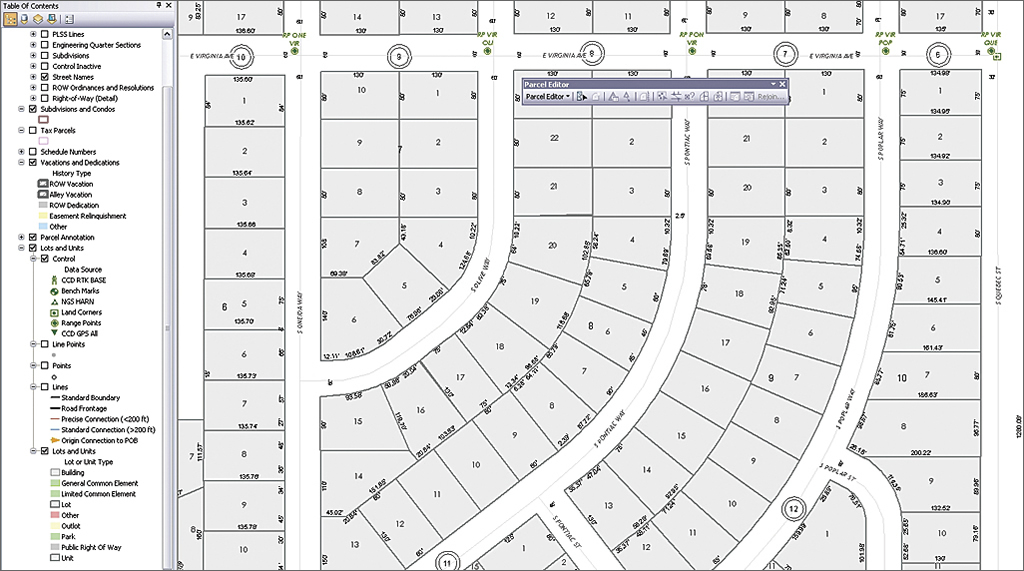
Denver's Survey Editing Map is designed for the editing of lots, subdivisions, and ordinances and importing and assessing the accuracy of control point data.
After gathering requirements, DenverGIS decided to use the Esri Parcel Fabric Template and extend the data model as needed. Before the conversion, DenverGIS had no comprehensive control point layer. Surveyors maintained points not only in different files but also in several formats (e.g., Microsoft Excel, Esri shapefile, ArcGIS file geodatabase, AutoCAD), making data difficult to access. It was also difficult to determine if files contained duplicate data points.
"To build the control network, we gathered more than 8,000 survey control points from those various data formats, identified the duplicates, and retired less accurate points," said Genzer. Benefits from the actual conversion process included discovering and fixing more than 1,000 geometric and attribute errors, consolidating survey control point data into one GIS layer, and creating a cadastral dataset that complied with Federal Geographic Data Committee standards.
The new system went into production in January 2011. The project successfully converted all existing datasets and identified inconsistencies and minor data issues. Improved workflow processes are increasing parcel geometric accuracy over time.
The ArcGIS Workflow Manager extension now manages the work process and has improved coordination between departments in terms of communication, quality, and timeliness. DenverGIS used Workflow Manager to create editing workflows specific to each department's editing needs. Both the Public Works Survey and Assessment groups' workflows contain an editing map optimized for the maintenance of the cadastral features those groups have authorization to edit. The maps use feature editing templates containing only the features specific to their work.
Workflow Manager also manages versioned editing of the fabric, which enabled Genzer and his team to incorporate automated e-mail alerts. "Our workflows send e-mail notifications when a step is completed that alerts the Assessment group that the Survey group has made a significant change," said Genzer. "If a survey edit affects a parcel, it will alert the Assessment group to get the approval for it."
Innovative County Is Early Adopter

Mono County maintains more than 21,000 parcels within its parcel fabric. Its public-facing Parcel Information System website, online since 2010, has received praise from all county departments for delivering more accurate and frequently updated cadastral data.
The Mono County Assessor's Office manages cadastral information for Mono County and the Town of Mammoth Lakes in California's beautiful eastern Sierra Nevada. As early as 2004, the county began investigating a more efficient and integrated solution for producing and maintaining parcel data in its GIS.
"We worked very closely with Esri in those early stages of GIS-based parcel management, because at the time there wasn't a standardized data model or dedicated set of tools we could rely on," said Nate Greenberg, GIS coordinator for Mono County and the Town of Mammoth Lakes. "Managing cadastral data at the time meant working in standard feature classes with a set of topology rules applied to them to ensure data integrity and facilitate editing workflows." While that process was vastly superior to a CAD-only workflow, Greenberg and his team found it challenging to strike a balance between maintaining accurate dimensions for a parcel and fitting that parcel into surrounding parcels.
Mono County's head start on parcel management prompted an invitation to become part of Esri's Cadastral Editor beta program in 2007, and the county officially became an early adopter of the methodology. In the ensuing years, Greenberg worked closely with Esri's cadastral team and the Mono County Assessor's Office to help influence product development, testing and implementing improvements to the tool and data.
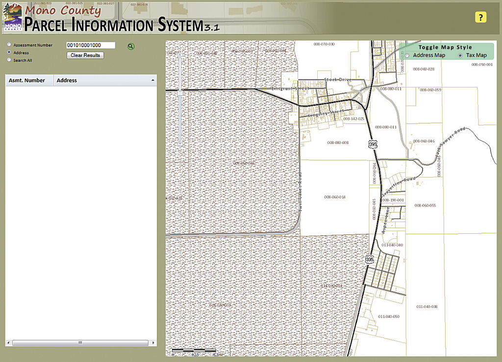
Mono County's Parcel Information System makes its parcel information publicly accessible.
"We had strong coordination between our GIS staff, Assessor's Office staff, and Esri's cadastral team to identify the parts that needed refinement and discuss ways to improve the editing experience within ArcGIS," said Greenberg. "It's been really fun and rewarding to help the product grow and see the quality, stability, and ease of use improve."
When Mono County first started managing parcels with the ArcGIS Survey Analyst extension, even simple operations like modifying attributes of parcels in the fabric were laborious. Now, common editing operations, such as attribute editing, are tightly integrated into the ArcGIS user interface.
With the release of ArcGIS 10.1, the data loader has been optimized to overcome traditional flaws in parcel data that cause inaccuracy such as poorly rendered curves or overlapping geometry. Now the data loader runs as a geoprocessing tool against topology that contains rules to ensure cleaner geometry. Parcels must meet the data loader's standards before being committed to the fabric. These improvements to the migration process caused Greenberg and his team to load data on condominiums, subdivisions, and general common elements, which had previously been maintained as separate feature classes, into the fabric.
Moving to the Parcel Fabric
When asked what advice he would give to governments and agencies considering the move to the parcel fabric, Greenberg offered a general game plan: "First, demonstrate the technology in a small-scale pilot project to get buy-in from key stakeholders, such as cadastral mappers, assessors, and other personnel that depend on parcel data. Second, carefully consider data conversion from your legacy systems to the parcel fabric, and devise a phased approach that includes getting data into the system, cleaning it up once it's loaded, and maintaining it going forward."
To help governments transition to the parcel fabric, Esri created the Local Government Information Model, which harmonizes GIS datasets, web services, and maps. It connects information silos and integrates processes across typical government departments. It includes foundation layers and operational information that support key maps and applications in local government. To download it, visit ArcGIS for Land Records, a public group on ArcGIS.com that provides maps, applications, and best practices information.