|
Editor's
Note: Market information is important for both buyers and sellers
of recycling materials. GIS provides a way for manufacturers and
market researchers to research the geographic distribution of recycling
materials. Currently information on recycling markets information
is not widely available to interested parties.
The authors
used ArcView GIS, ArcView Internet Map Server (IMS), Avenue, and
HTML programming to develop the Recycling Markets Information System
(RMIS). This Internet-based application allows interactive access
to data on recycling in Texas by buyers, sellers, and recycling
market researchers. It was sponsored by the Office of Pollution
Prevention and Recycling at the Texas Natural Resource Conservation
Commission (TNRCC).
As America is
going online, a system like RMIS makes data on recycling more widely
accessible anywhere anytime. It improves data sharing and is more
cost-effective than other methods. RMIS provides the following four
main functions
- Assists in locating facilities that take household recyclables
- Provides locations of buyers of large quantities of recyclable materials
- Provides locations of sellers of recyclable materials
- Helps identify potential sources and markets for recyclable materials in Texas
Databases
in RMIS
RMIS contains
both spatial and attribute data. Spatial data include the locations
of companies that collect, sell, and process recycling materials;
cities and counties that have community recycling programs; and
manufacturers. In addition, databases with various related geographic
features (roads, active landfills, interstate highways, and boundary
information for counties and councils of governments (COGs), were
included.
Twelve attribute
tables (listed in Figure 1) are needed by the application to satisfy
the queries of potential buyers and sellers. Based on how the data
are used, the attribute data can be categorized as information related
to the RecycleTexas programs (e.g., rt_accept.txt), information
related to communities with recycling programs (e.g., gd_mtls.txt),
or information related to manufacturers (e.g., mn_sic2all.txt).
LIST OF ATTRIBUTE TABLES
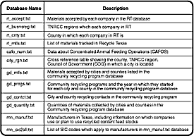
[Figure1] Functions and Their Implementation
Functions in
RMIS are grouped into four modules. The first module helps users
locate facilities that accept small household quantities of recyclable
materials. The second module allows users to query and locate on
a map companies in the Recycle Texas program that buy a given material.
Recycle Texas is sponsored by Ecology Action, a nonprofit organization
that is one of the oldest organizations in the country dedicated
to recycling. The third module retrieves and displays sellers of
a given material in both the Recycle Texas program and community
recycling programs. The fourth module helps market researchers identify
potential sources and recycling markets for recyclable materials
in Texas.
Here, the second
module is used to illustrate the same design, implementation, and
operation of RMIS. The other three modules were created and function
in a similar fashion. The search procedure used by the second module
is illustrated in Figure 2. A customer with a certain material to
sell selects a material category from a drop-down list of material
categories provided by RMIS. Next, the customer selects a material
type that is a subset of the category chosen in the previous step.
Finally, the customer enters a county name, city name, or both.
RMIS searches the databases, finds companies satisfying all three
input conditions, and presents the results as a map, list, or both.
DIAGRAM OF QUERY
PROCESS
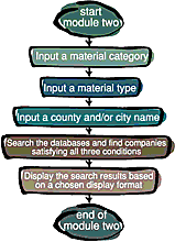
[Figure 2]
The system was
implemented using ArcView GIS, ArcView IMS, and Avenue. All spatial
data were represented as shapefiles in ArcView GIS. All attribute
data were imported to ArcView GIS. Related spatial data and attributes
were either joined or linked together based on the relationships
between them.
RMIS in Operation
and Sample Results
The operational
aspects and related results from module two are illustrated in Figures
3 to 5. Figure 3 shows the input screen used to make a query.
INPUT INTERFACE
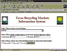
[Figure 3]
As an example,
if the material category given by the customer is biomass, the chosen
material type within the biomass category is bedding, and the chosen
city is Dallas, then there are only two companies found in the databases.
The locations and addresses of these two companies can be displayed
(Figure 4).
SEARCH RESULTS
[Figure 4]
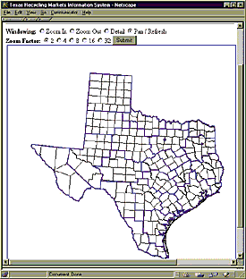
The interactive
mapping function is a very important part of RMIS. A customer can
select a number of features to be drawn on the map and zoom in or
out to obtain the information needed. Figure 5 is a more detailed
map showing the two companies shown in Figure 4 with more features
included in the map.
ZOOMED IN VIEW
OF SEARCH RESULTS
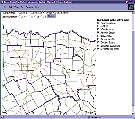
[Figure 5] Example of More Detailed Display of Search Results
This application
demonstrates how ArcView GIS, ArcView IMS, and Avenue provide a
powerful and convenient environment for developing Internet-based
GIS.
References
Environmental
Systems Research Institute, Inc. Using ArcView GIS. Redlands,
California: Esri, 1996
-- Using Avenue. Redlands, California: Esri, 1996.
Graham, Ian
S. HTML Source Book. John Wiley & Sons, Inc., 1996.
Razavi, Amir
H. ArcView/Avenue Developer's Guide. Santa Fe, New Mexico:
OnWord Press, 1995.
Razavi, Amir
H., John Alexander, and Valerie Warwick. ArcView/Avenue Programmer's
Reference. Santa Fe, New Mexico: OnWord Press, 1995.
Acknowledgment
The authors
would like to thank Alan Watts, Susan Reid, and Heidi Wittenborn
of TNRCC for their support and assistance during the development
of the system. The authors would also like to thank Joseph B. Bowles,
Dal Hunter, and Henry Hagemeier from Esri–San Antonio for the
technical assistance they provided during the initial stage of this
project.
For more information
please contact
Dr. Benjamin Zhan
Southwest Texas State University
601 University Drive
San Marcos, Texas 78666
Tel.: 512-245-8353
E-mail: fz01@swt.edu
About the
Authors
Dr. Benjamin
Zhan is an assistant professor in the Department of Geography and
Planning at Southwest Texas State University. Dr. Zhan's major research
interests are transportation and environmental analyses, GIS, spatial
databases, and spatial statistics. He obtained his Ph.D. from the
Department of Geography at the State University of New York at Buffalo.
Dr. Robert Larsen
is a professor of geography and planning at Southwest Texas State
University.
Xinnong Zhou
is a doctoral student in the Department of Geography and Planning
at Southwest Texas State University.
|