On Demand, In Demand—ArcWeb Services
 |
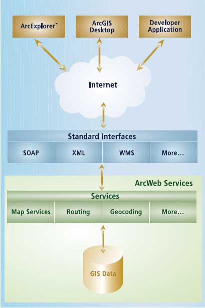
| ArcWeb Services are built on industry standards and can be deployed using standard Web protocols and languages. |
ArcWeb Services furnish dynamic, up-to-date content and capabilities that can be deployed online and on the desktop in a variety of ways that are tailored to the needs of users. While providing on-demand access to datasets and online GIS functionality without the cost and trouble of developing or maintaining either, ArcWeb Services also allow for tremendous deployment flexibility.
For end users, ArcWeb Services furnish robust and current commercial datasets to ArcGIS Desktop users and prepackaged report and map solutions for specific industry areas. For developers, ArcWeb Services provide a method for GIS enabling custom Web applications without the effort and expense of managing the data or creating GIS-related functionality. Users of ArcIMS and ArcGIS Server can also use ArcWeb Services to extend existing implementations with additional data and services.
Data is supplied in an array of formats including street maps, live weather maps, digital orthophoto quarter quadrangles (DOQQs), topographic maps, live traffic information, shaded relief imagery, flood data, and census data. Data offerings are continually expanding. Data providers currently include Geographic Data Technology (GDT), Tele Atlas/TomTom, Meteorlogix, GlobeXplorer, Pixxures, National Geographic, Esri, and TrafficCast.
ArcWeb Services functionality includes
- Generating a dynamic map of a specific location
- Locating a place such as a city or river anywhere in the world
- Locating street addresses in North America, Europe, and New Zealand
- Generating a route with driving directions for multiple locations
- Determining the characteristics such as population or flood potential for a specific location
- Uploading custom points of interest that can be used on maps and in proximity searches
- Performing proximity searches for points of interest
For End Users
ArcGIS Desktop users at any license level can use the ArcWeb toolbar to access datasets from leading data vendors from within ArcMap. Weather, traffic count, and other data that benefits from near real-time currency would not be practical or cost effective to obtain any other way.
Focused solutions are also available by subscription download that gives end users easy access to maps and geographic-based reports built on ArcWeb Services. The focused solutions currently available are
- Business Analyst Online, which combines GIS with business, demographic, and consumer household data and capabilities that were previously only available from Esri's ArcGIS Business Analyst extension.
- MapShop for Media, which is an affordable and easy way to create maps of any location in the world, that was designed for media outlets.
- MapShop for Homeland Security, which provides emergency and crisis management centers with the ability to create a common operating picture and access detailed data for a specific event.
- Flood Map Report, which helps determine the relative flood risk of a specific location. It was created using Federal Emergency Management Agency Q3 Flood Data and GDT Dynamap/2000 street data.
For Developers
Because ArcWeb Services are built on industry standards, they can be deployed using standard Web protocols and languages. ArcWeb Services use the XML-based Simple Object Access Protocol (SOAP) to communicate and, therefore, are compatible with the majority of Web services. There is no requirement to learn new languages or environments. Popular frameworks, such as Microsoft .NET or webMethods Glue, can be used to create sites quickly.
The ArcWeb Services application programming interfaces (APIs) are fully documented, and the help system includes method and object descriptions, tutorials, code samples, and live client samples. Fully developed ArcWeb sample applications can be explored at the ArcWeb Showcase (www.esri.com/arcweb). Source code is available for some of these applications. These applications, written in a variety of programming environments, track vehicles in real time, generate driving directions, show current weather conditions, and locate a home that matches user-specified criteria.
ArcWeb Services are based on an Esri-hosted infrastructure powered by leading edge technologies. Two complete configurations are maintained at geographically separate locations to provide full system redundancy and load balancing. This robust, reliable system has the capability of delivering 5,000,000 maps per day above a 99.9 percent availability rate.
The ArcWeb Services system is monitored and maintained by Esri staff on a 24/7 basis. Esri staff members are on-site during standard business hours (8:00 a.m. to 5:00 p.m., Pacific time) and available by pager during nonbusiness hours to respond to system interruptions. Esri also has high-level support agreements with its hardware and network vendors that guarantee prompt response.
Try It Out
A free, one-month evaluation that includes all content and capabilities is available for both developers and ArcGIS Desktop users. Users who will be using ArcWeb Services on the ArcGIS Desktop should also download the free ArcWeb toolbar. This toolbar provides direct access to ArcWeb Services within the desktop environment.
This section contains two tutorials that make use of the free ArcWeb Services evaluation subscription. One tutorial introduces readers to the data, functionality, and ease of use of ArcWeb Services for desktop users. The other tutorial shows how to customize one of the applications available from the ArcWeb Showcase in the .NET environment.
Learn More
The ArcWeb documentation, available with the evaluation subscription, provides tutorials, live samples, object models, and code samples. Because it is browser-based help, it is constantly updated. A discussion forum and technical support are also available. At the Esri Support Center, ArcWeb users can access the knowledge base, read white papers, and download the site starters.
|