Mapping an Underground Threat to National Parks With ArcPad
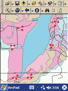 |
| This map was used for collecting data at Pictured Rocks National Lakeshore. Possible plot points are shown as red dots while the colored areas represent vegetation coverages. |
In February 2004, researchers at the Natural Resources Research Institute (NRRI) and National Park Service initiated development of a personal geodatabase for an earthworm inventory to be conducted during summer 2004. This study would measure the impact of European earthworm invasions on vegetation and soil characteristics at two Great Lakes national parks—Pictured Rocks National Lakeshore, located in the Upper Peninsula of Michigan, and Voyageurs National Park, located in northern Minnesota.
Earthworms can significantly change soil composition which, in turn, can alter the type and number of plant species in a park. The information gathered by the inventory will be used to document the spread of earthworms from probable invasion points as well as measure the impact these earthworms have had on the local vegetation. This data will also become part of the National Park Service's Inventory and Monitoring program. The principal investigators wanted to use handheld computers (PDAs) for data collection and decided that this project would be a good opportunity to create a customized ArcPad solution.
Project Design
By using maps that included data on soil characteristics and vegetation coverage, researchers tentatively identified discrete sites within each park that met specific criteria for inclusion in the study. From those sites, they picked approximately 120 10-meter by 10-meter plots where surveys of the plant species, earthworm populations, and soil characteristics would be conducted. These plots were represented as points on a map. Once in the field, researchers used Pocket PCs in conjunction with handheld GPS units to navigate to each plot. If, on inspection, a plot did not meet the study criteria, researchers would look for a more suitable site nearby. When one was found, the plot points would be relocated in the ArcPad project using the GPS unit.
At each site, information on each plot would be recorded through seven different surveys on herbaceous plants, seedlings, small and large saplings and shrubs, trees, earthworm populations, and soil characteristics. Potentially, each survey could be conducted by different researchers at different times. For example, at one plot, one researcher might conduct surveys of all herbaceous plants and seedlings, while another researcher might survey the small and large shrubs. Later, two other researchers might revisit the plot to conduct the earthworm and soil surveys. ArcPad customization was needed to allow NRRI personnel to collect data from the various surveys for each plot. The final solution included both a customized ArcPad layer and an applet.
Customized ArcPad Layer
Because researchers wanted to identify 120 plot points in two national parks, a customized Plots layer was created for use with each map. The Plots shapefile contained extensive information about each plot that included its location within the park, land characteristics, and overall vegetation condition. This information was stored as attributes of the Plots shapefile. It was easy to use ArcPad Studio in ArcPad Application Builder to create a customized edit form to furnish this information to the researchers for editing. External data tables were used extensively to store the lookup values for the combo boxes that presented data entry choices to researchers.
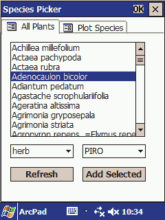 |
| The main tab of the SpeciesPicker Applet displays all the herbaceous plants found at Pictured Rocks National Lakeshore. The Add Selected button adds the selected plants to a smaller list of plants displayed on the Plot Species tab. |
A different approach was taken for the actual survey data that researchers collected. Survey data for each plot was stored in external dBASE (DBF) tables. Separate pages showed the data currently collected for each individual survey at a specific plot so researchers could get a quick overview of the data collected at each plot and still have the option to add, edit, or delete records associated with that plot.
Separate data entry forms were created for each survey. Again, combo boxes were used extensively to ensure only valid data was entered. Data entry forms were also programmed to check for missing data. If one or more fields were unselected, the record would be marked as incomplete. If desired, the user could view only the incomplete records on the plot survey data page.
Applet Manages Species List
In addition to the customized layer, a custom applet was created to support data entry. At each park, researchers could encounter thousands of native plant species while surveying plots. A drop-down list with thousands of entries was not practical. However, an applet called SpeciesPicker was developed that allows researchers to dynamically prune the list of plant species for a given plot survey while maintaining a comprehensive list of all plant species for a given park.
Generating a separate, smaller table to populate the combo boxes was necessary because the Pocket PCs did not have enough processing power to dynamically select and display a subset of the plants table, which contained thousands of species. When using the entire plant table, the time to open a page and populate the combo box was interminable.
The SpeciesPicker applet presents information about all plant species found in both parks in a list sorted by scientific name. This information was compiled by researchers and stored in an external DBF table. SpeciesPicker allows the user to filter the list by plant type and park. The user can select individual plants from the entire list and add them to a separate external DBF table. This smaller table is then used as the source of combo boxes presented to users conducting plant surveys.
Project Considerations
The project took one programmer, who was proficient in coding in Visual Basic for Applications but who was a complete novice at ArcPad and ArcPad Studio, about one month to create the entire customized layer and applet. In addition to many customized data collection pages, approximately 2,000 lines of VBScript were written as part of this project.
During summer 2004, the application was used to collect data that will be used by NRRI researchers to study the effects of exotic earthworm invasions on the national parks. This data will also be used by the National Park Service to document and monitor the spread of invading earthworms. Using ArcPad to tie data from the Plots shapefile to survey data stored in external DBF tables made this project unique. Researchers hope to use ArcPad in the future for other data collection efforts in the national parks. For further information or to obtain a sample version of the customization created for this project, please contact
Jim Dabrowski
National Park Service
Midwest Region GIS Technical Support Center
B102 Steenbock
550 Babcock Drive
Madison, Wisconsin 53706
E-mail: jrdabrowski@wisc.edu
About the Author
Jim Dabrowski is a database programmer with the National Park Service. He has a master's degree in computer science from the University of Wisconsin, Milwaukee.
|