October - December 2004
October - December 2004 |
||||||||
|
|
||||||||
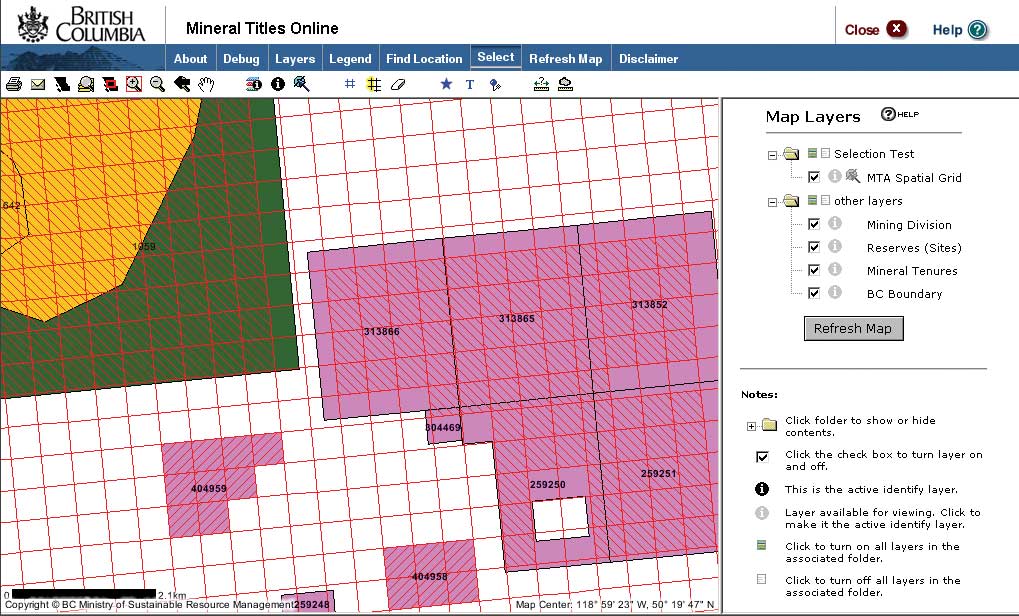
These new ministries faced a reduction in the workforce as well as an increased need for reengineered technical applications and a leaner, enhanced administrative system. This called for a collaborative and integrated approach that forced government to utilize common infrastructure and IT services to achieve service delivery. British Columbia is committed to enhancing mineral title administration by adopting an e-commerce, GIS-based map selection system. Mineral Titles Online (MTO), a program of the Ministry of Energy and Mines (MEM), promotes efficient administration. Developed by Esri Canada Limited Business Partner Pacific GeoTech Systems Ltd. in collaboration with the Titles Division of MEM as well as the Ministry of Sustainable Resource Management, its goal is to provide a positive administrative environment that will support increased mining exploration and development activity in the province. MTO is the first e-commerce, GIS Web-enabled system for mineral title acquisition in British Columbia. With this system, members of the mineral exploration industry, authorized agents, and staff from mining companies can acquire mining rights by selecting a claim on an electronic map rather than staking a claim on the ground. Establishing secure title on an accurate digital map base integrated with other online resources will streamline the entire claim acquisition process. Most existing claims are plotted on 40-year-old basemaps that are supported by a 14-year-old attribute database. The maps are digital, but the associated information can be incomplete or out of date. In 1998, the ministry began to convert all claim maps to a common computerized database called TRIM (Terrain Resource Inventory Mapping). The conversion process imports the existing mineral titles onto the map and corrects and updates the geographic details. These maps will provide a very accurate platform for MTO. "When we first discussed map selection with our industry clients, it didn't take long for us to realize that tenure issuance had to be instant and that this required a major overhaul of our entire administration system," said Rick Conte, MTO project director. In 2002, Richard Neufeld, the minister of Energy and Mines, announced the move toward a map selection acquisition system. An industry consultation process and research began in earnest. The need to make the selection of a title and the actual title issuance a nearly instantaneous process was imperative. MTO incorporates a digital map selection process and capitalizes on a host of governmentwide initiatives that offer Internet-based delivery of digital maps, greater access to information, and a secure administration system for electronic payments. Powered by Pacific GeoTech Systems' truePERMIT solution, MTO was developed and implemented using ArcIMS, ArcSDE, XML, Java, Java 2 Platform, Enterprise Edition (J2EE), Apache Ant, Log4J, Oracle, Apache Struts Framework Model-View-Controller-2 (MVC2), design patterns, and the government's MIRA Java Payment and Internet Mapping Framework (IMF). The entire MTO system is Web based and accessible through a standard Web browser. MTO provides robust, secure, and powerful geospatial capabilities and validation that works with electronic, graphic, and attributes standards and supplies online help. The initial phase of MTO implementation in spring 2004 allowed internal authentication of client data, viewing of spatial and attribute data online, selection of tenure for acquisition via electronic maps, and acquisition of free miner certificates (FMC). These functions will allow for a full range of testing and training for staff and industry. In the future, MTO will also incorporate subsurface mineral and placer titles administration and provide recording of applications for all title transactions that is fully Web based. MTO was unveiled by MEM and Pacific GeoTech at the Mineral Exploration Roundup Conference in Vancouver, British Columbia (BC), in January 2004. MTO Project Manager Jim Turner, who attended the conference, remarked, "We realized that with so many other leading edge e-commerce activities being developed within the BC government infrastructure, MTO became an obvious fit to develop a business application that could capitalize on developing e-government objectives in BC." With MTO, the tenure application process is more rigorous and efficient. Industry clients benefit from electronic selection, secure access to up-to-date government geospatial data, faster resolution of title conflicts, and-ultimately-faster permit processing. The e-commerce capabilities of MTO will also mean that payments can be securely made online, which further reduces processing time. MTO also allows MEM to provide enhanced services related to mineral claims and reduce processing and administrative costs, which fulfills British Columbia's e-government objectives. In addition, MTO may be used for other MEM regulatory functions. MTO will meet the current business needs of MEM and its clients. It will also help ensure government compatibility with other Web-based systems and applications developed in the future. The target for the implementation of MTO is January 2005, and the system will be further developed and tested over the next couple of years. Throughout the development of MTO, MEM will continue to ask for input from the mineral exploration industry, government agencies, and the public. While the internal implementation will be staggered over a period of time, MEM will be responsible for maintaining an orderly and secure transition of title. MEM will also provide training and orientation to clients throughout the consultation phase and before implementation. All existing claims will continue and will be displayed relative to the new online map grid. The ministry is confident that most existing claims will be merged with the grid over time. A number of incentives will be put in place to achieve this goal. The ministry is also committed to continue improving MTO and offering assistance and training to clients. For more information, visit MTO at www.em.gov.bc.ca/mtonline or Pacific GeoTech Systems Ltd. at www.pacificgeotech.com or contact Andy Lang, marketing director for Pacific GeoTech Systems Ltd., at alang@pacificgeotech.com or 250-216-5025. |