October - December 2007
October - December 2007 |
||||||||
|
|
||||||||
According to Kenneth Bennett, division manager of the Precincting, GIS, and Election Tally Systems Division of the Los Angeles County Registrar-Recorder/County Clerk (RR/CC), "The voter landscape is constantly changing in any urban area. Voters are moving into an area or they are moving out, and new voters are coming of age—all kinds of things are happening—which means that all that voter registration activity collides with the address data, changing the way precinct and district boundaries need to be drawn. For the Registrar of Voters, boundary management is a continuous process of collecting new information and responding to it." Bennett's insight is based on years of experience helping to develop a GIS-based precincting and redistricting system using Esri software for the county's RR/CC. Los Angeles County, with a population approaching 10 million people, has more than 400 districts. During a typical year, RR/CC may conduct more than 60 separate elections. "Within our jurisdiction, we have to provide accurate precinct boundaries to all the cities and districts participating in any given election, and we have to confirm that each district boundary properly matches our precinct boundaries. We use GIS to manage election-related boundaries and confirm their accuracy, as well as efficiently support numerous election activities," said Bennett. Precinct Planning
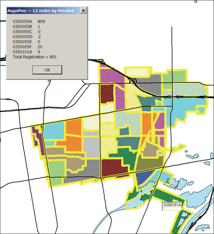
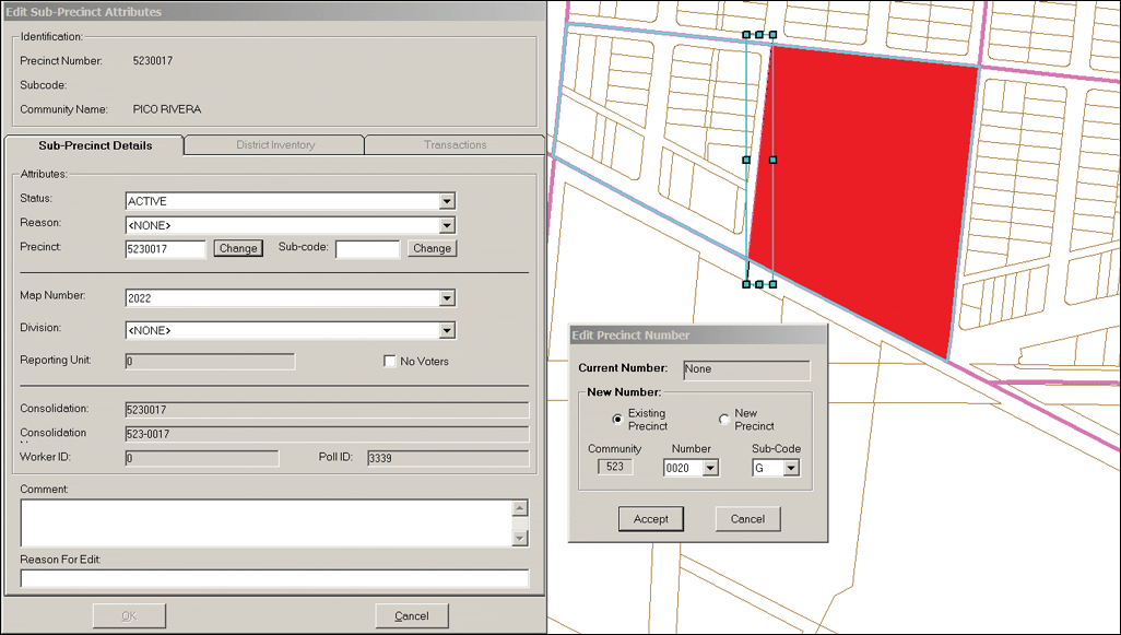
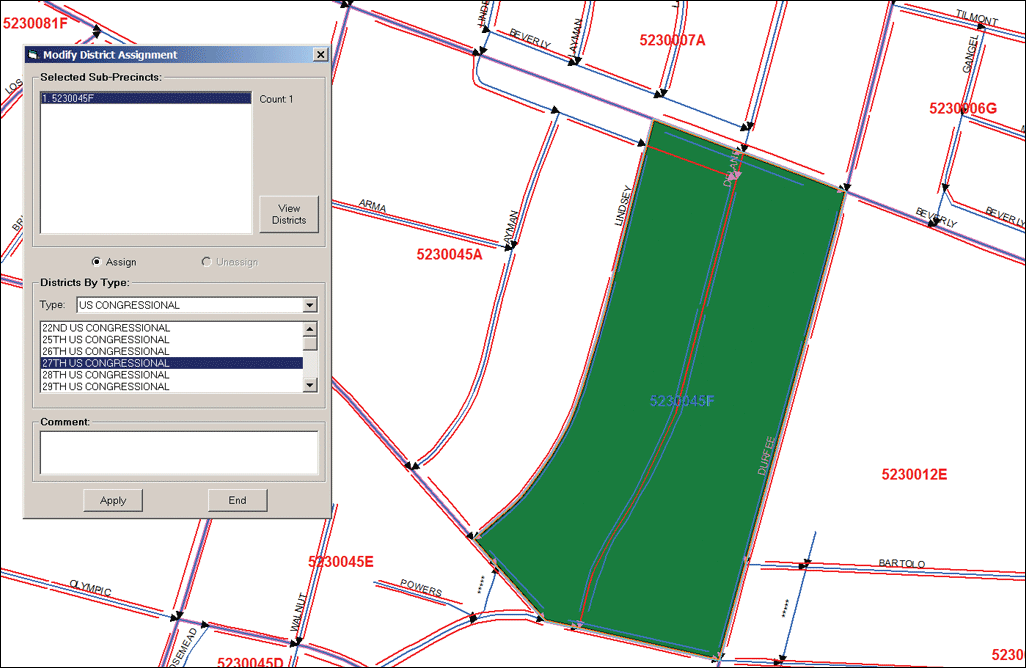
Planning for elections begins months in advance. Using an application called Precinct Consolidation, established precincts are grouped by district assignments. Some precincts have dozens of district assignments. This allows RR/CC to create ballot groups or ballot styles—geographic areas that have the same district characteristics for the active districts in an election. Once the ballot groups for a particular election have been identified, Precinct Consolidation is used to combine established precincts within the same ballot group into election precincts. The application is vital for ensuring that everyone within a particular election precinct is voting on the same set of contests. Bennett points out that his team must incorporate dozens of spatial considerations into the precinct consolidation process. "When we are combining precincts to form an election precinct, they have to be contiguous. For example, here in California, we don't want a six-lane freeway running through the middle of an election precinct making it difficult for voters to reach their polling place. We have to consider any natural or man-made barriers that obstruct voter access. We cannot, for example, mix voters living inside and outside of a gated community when the polling place is inside the gates. GIS helps us solve these types of problems, while also helping us to ensure that precinct boundaries are accurate and voter counts are under any prescribed limits." Election Data Management SystemRR/CC use Esri's ArcGIS software to implement a customized GIS as a front-end election data management system that enables the division's users to make original edits to precincts, district assignments, and street segments directly through a digital map interface. Like many counties, after the decennial census is taken, RR/CC is faced with the formidable task of editing the precinct data layer to reflect the new district boundaries drawn by the state, based on the new demographics—a process referred to as reapportionment. "After the census, we will use our front-end GIS-based data entry system to implement the reapportionment," said Bennett. Previously, large format hard-copy printed maps were marked up and changes were manually entered into the voter information management system. The process of editing tabular records was laborious and error prone. This time, RR/CC will accomplish the task using GIS and digital maps. "We will be using spatial analysis to validate precinct layer edits and to automatically assign street address ranges to the proper precincts after the edits are made. The GIS will make the process of reapportionment more accurate, less time-consuming, and help eliminate errors," said Bennett.
In addition to precinct consolidation and redistricting, RR/CC uses Esri's GIS technology to support nearly every aspect of elections. ArcIMS powers a public-facing Web site that helps citizens locate polling places based on their home addresses. Polling inspectors use an automated GIS application to create and print adjacent precinct maps to help voters who show up at the wrong place find the correct polling place. Another ArcIMS application scouts out new polling places. A Better Way to Find Polling PlacesPolling place recruitment is another process that takes place months in advance. With this Web application, RR/CC uses high-resolution aerial imagery purchased through the Los Angeles Region Imagery Acquisition Consortium, whose members include various county departments and numerous cities, including Long Beach and Los Angeles, as well as the Metropolitan Water District. Poll recruitment staffs are constantly looking for new polling places. In the past, they would do "windshield surveys." Recruitment staff members would drive around looking for suitable polling places. "With this ArcIMS application, poll recruiters can inspect the imagery from their desktops and form a preliminary list of candidates before they get in their cars. They can assess characteristics like parking, handicap access, and building size, as well as potential constraints like one-way streets," said Bennett. "Prescreening sites using GIS will significantly increase polling place recruitment productivity." RR/CC uses the same application to locate regional election distribution centers, election check-in centers (where poll inspectors return voted ballots and other election materials), and training facilities for the 25,000 poll workers that participate in every election. Extending GIS to Election ManagementAccording to Bennett, using GIS for precincting and redistricting and other election support activities is still an unexplored world for many counties. "Local governments embrace GIS technology in land-use planning, parcel database maintenance, transportation analysis, and infrastructure management. So, why not election support? For those of us working at the Los Angeles County Registrar-Recorder/County Clerk, GIS technology serves an essential facet of our work—increasing our effectiveness, improving reliability, and boosting productivity." Visit www.lavote.net to learn more about how the Precincting, GIS, and Election Tally Systems Division of the Los Angeles County Registrar-Recorder/County Clerk is using GIS to support elections. Bennett is coauthor of a white paper, Building a Custom GIS-Based Precincting and Redistricting System, July 2005, that explains the system in detail and is geared toward agencies that are interested in using GIS to support implementation of the upcoming 2010 decennial census reapportionment. |