
City of Barstow
GIS Real Estate Application Spurs Land Sales
Jennifer Riley, GIS coordinator for the City of Barstow, California, went looking for a park site and ended up finding $644,000 worth of real estate sales since April 1997.
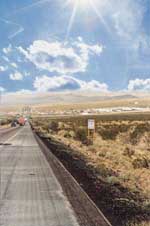
This city of 22,000 is located in the high desert of Southern California and covers 40 square miles. Riley, GIS coordinator and environmental manager for the City for the past five years, worked with Mike Massimini, an assistant planner, and Domingo Gonzales, an engineering technician, to create an application in ArcView GIS that would easily locate commercial and industrial properties so they could be sold and developed.
The application grew out of a request to find a site for a proposed park. Since the City does not have separate zoning for parks, Riley needed to find industrially or commercially zoned parcels that were either owned by the City or available for purchase and development. Though Barstow had acquired some parcels through foreclosure proceedings, there was no comprehensive inventory of the City's holdings.
Riley used ArcView GIS to quickly identify all suitable sites. Once the industrial and commercial parcels were located, it occurred to Riley that this information could be used to encourage land sales and economic development in Barstow. Though GIS is used for some specific applications such as pavement management, Barstow does not have an enterprisewide GIS and the overall level of computerization throughout the City is not high. Consequently, Riley and her cohorts wanted to keep the system simple to operate and inexpensive to maintain.
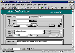
The application designed by Gonzales runs on a Pentium 166 PC and uses ArcView GIS and Access database software. The database is directly linked to a parcel or street basemap. The database includes standardized information on each of the 35 parcels currently in the program including information on ownership and what an owner is willing to do to sell the property such as subdivide it, provide financing, or build to order.
Commercial and industrial properties are often difficult to sell because information is scarce, analysis of potential sites difficult, and locating the site often challenging. ArcView GIS allowed users to see exactly where and what properties were available and see them in relation to one another, as well as surrounding property uses and infrastructure. Two of the 10 City-owned parcels are in escrow. Eight parcels listed by brokers have sold and two other parcels have been leased.
 Currently, five real estate brokers are participating in the program. This real estate broker program is part of a larger regional marketing board plan to increase commerce within the high desert region. When brokers want to add a parcel to the program, they fill out a paper form that is inputted. However, by year's end, Riley hopes to have a system in place that will allow brokers to dial in to the system to file new parcels or search the database.
While the property locator application holds the promise of directly generating funds for the City by disposing of the 10 City-owned parcels included in the database, it also fulfills several other functions for the City. By encouraging economic development, it is working toward the long-term goal of increasing the City's revenue base. The City has a mandate to streamline City services and make them more accessible. This self-help application alleviates the workload for a limited staff and fits well with overall plans to automate information services for Barstow's police and redevelopment departments.
To contact Jennifer Riley, send mail to 220 East Mountain View, Barstow, CA 92311 USA.