Cape Town's Emphasis on Systems Integration Exemplifies "Smart City" Goals
By Jim Baumann, Esri writer
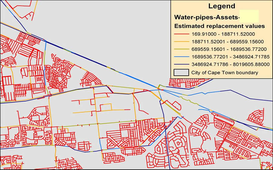 GIS can indicate spatially the replacement value of the current infrastructure. |
Seven neighboring municipalities were incorporated into the city of Cape Town in the Republic of South Africa in 2001 to consolidate and streamline government services across the Cape Town metropolitan area. Cape Town, with a population of approximately 3.2 million, immediately became responsible for managing a number of antiquated, stand-alone information management systems holding disparate data in at least seven different IT centers across the new city.
The Cape Town IT Department wanted to create a better flow of information among various city departments and provide more efficient services for residents. Committing itself to a holistic and comprehensive "smart city" strategy, the IT Department initiated a number of projects to standardize the information and communication technology (ICT) architecture and connect constituent parts.
Key to the success of the smart city strategy was the implementation of the enterprise resource planning (ERP) system, which saw approximately 113 legacy systems and 70 interfaces replaced with a single functionally rich SAP solution designed to standardize and optimize all of the city's business processes. Recognized as one of the world's largest ERP systems ever implemented by a local government, it has a custom-designed billing system to help streamline the accounting process.
Next, the city integrated a geographic information system (GIS) into the information system infrastructure. While GIS was used throughout the various local councils prior to the amalgamation, the technology primarily functioned within stand-alone systems with little standardization and limited compatibility. To reform this particular legacy, Cape Town implemented an enterprise GIS based on Esri's ArcGIS platform. This allowed extensive functionality within a multiuser environment and provided an effective spatial data management platform for its many users. Initially, the city concentrated on consolidating electricity and property geodatabases into the GIS and subsequently added the Water Services geodatabase to the GIS process. Since then, a number of other departments, such as Planning and Valuations, have started implementing GIS technology. ArcGIS was successfully implemented into participating departments as the city focused on integration issues, such as user profiles, as well as standardized data capturing and maintenance of departmental geodatabases.
Cape Town's Water Services proved to be the ideal utility from which to continue its GIS integration initiatives. South Africa is located in a semiarid region without many perennial rivers or lakes, requiring extensive conservation and water control measures. Cape Town also experiences a 3 percent annual population growth, placing an even greater strain on the city's limited water resources. Given these constraints, GIS provides one of the best possible means to collect, analyze, and model spatial data to optimize water conservation and demand strategies.
The SAP implementation enabled the city to establish an effective link between the system's business information capabilities and its location-based asset information—such as pipes, meters, reservoirs, treatment plants, and associated attribute data—stored in GIS. By taking advantage of this linkage, Cape Town is now able to extract the monthly maintenance costs for incidents, such as burst pipes and sewer blockages, as well as to evaluate water consumption patterns based on tariff structures.
There is also a link to the asset register, which is a model that runs against the GIS infrastructure geodatabase and is used to calculate solutions such as the life span of the various parts and components of the Water Services infrastructure. GIS can, therefore, be used as a tool to plan medium- and long-term budgeting of infrastructure projects such as replacing pipe infrastructure due to increased population demands or end-of-life-cycle redundancy. Next, the city will apply the lessons learned from the Water Services implementation to the development of a sewer and storm water geodatabase. Currently, the existing ArcEditor/ArcInfo 9.1 tools are utilized for multiuser editing in eight district offices, but the long-term vision is to develop a customized editing tool within the ArcGIS Server environment.
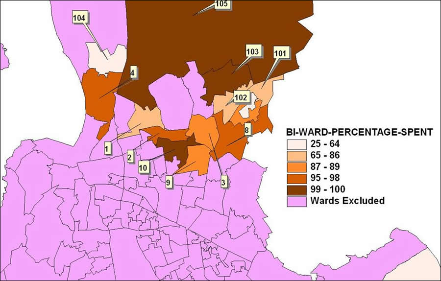 Percentage of capital budget allocation spent for 2006 per selected wards. Data for report originates from SAP Business Warehouse. |
The Water Services Department opened a Technical Operations Centre (TOC) that interfaces with the Corporate Call Centre to initiate operational responses and manage event tracking and logging. Currently, the Water Services Department is evaluating the available technology and interfacing options to develop a fully automated, spatially enabled event management system (EMS), defining an event as any operational activity requiring a response. EMS would be used to monitor and support the responsibilities of the city's employees to increase their efficiency. For example, EMS would automatically record the exact location of an event occurring in the city and analyze it to determine its impact on the surrounding area. Using location as a reference, the system would then identify assets the city has at any particular location and dispatch work crews to respond to the event. Workflows developed within EMS will allow the city to define and manage its standard operating procedures (SOPs) to support EMS. The workflows would analyze the system's automated response to an event and escalate the response to a higher level, demanding greater urgency, if required.
Because events will be spatially referenced, engineers will be able to interpret trends and patterns visually, which will allow them to be proactive in their response to events, according to Pieta Le Roux, GIS coordinator for the city's Water Services Department. In addition, TOC will coordinate responses to water/wastewater emergencies by integrating the notification and work order processes of SAP with mobile GPS/GIS and communication technologies. This integration will allow the city's supervisory control and data acquisition (SCADA) and telemetry systems' alarm components to be part of the central IT network and information infrastructure for quicker response to any malfunctions or anomalies occurring within the city's utility networks.
Commenting on the future Le Roux says, "The Cape Town Water Services Department will be implementing strategies and processes toward the transactional integration of GIS and SAP to provide the necessary life cycle views and real-time feedback of their asset maintenance environment."