Developing Spatial Thinking Skills in Education and Society
By Joseph J. Kerski, Ph.D., Education Industry Curriculum Development Manager, Esri
Spatial thinking has been receiving increased attention in the past several years. One reason could be the rapid expansion of geotechnologies from the GIS community to the general public including recreational GPS, in-car navigation devices, and virtual globe software. Another reason could be recognition that accelerating globalization means that we can no longer be complacent about increasing the amount of spatial thinking in the educational curriculum at all levels. We're also starting to realize that global issues, such as biodiversity loss, urban sprawl, energy needs, water quality and availability, natural hazards, and human health, are becoming increasingly complex and beginning to affect our everyday lives. Moreover, they all have a spatial component. To grapple with these issues for the 21st century requires a populace that's adept at using GIS and other geotechnologies.
Also piquing people's interest in spatial thinking may be the National Research Council's 2005 report, Learning to Think Spatially—GIS as a Support System in the K-12 Curriculum, which recommends that spatial thinking be recognized as a fundamental part of K-12 education due to its importance as a problem-solving tool in many different disciplines. Rather than as a separate course, it states that the United States needs a national initiative to integrate spatial thinking across the curriculum in courses such as mathematics, history, and science and that the country needs standards to be developed that can be used in teacher training and student assessment. This may be encouraging people to consider "graphicacy" equally important as teaching numeracy and literacy.
There may be other, equally valid reasons for the increased attention to spatial thinking and learning. Through Dr. Jerome Dobson's wonderful articles in ArcNews and elsewhere; Dr. Harm de Blij's book Why Geography Matters; and even through works by others outside the geography community, such as Thomas L. Friedman's The World Is Flat, the message is clear: we ignore the world at our peril. Those who have taught with GIS for the past few decades have long advocated spatial thinking as the foundation for success in problem solving with GIS. In fact, geographers and geography teachers have promoted spatial thinking for centuries.
Many welcome this new attention to spatial thinking and are hopeful for the future. Without spatial thinking, the complex issues facing our world cannot be effectively and completely dealt with. Without spatial thinking, scale may be critical to a problem but ignored. Without spatial thinking, a person can be proficient in working with GIS software tools but will likely have difficulty in thinking outside the software box, considering problems holistically, and examining problems from a spatial perspective, whether they use GIS or other tools.
Space, Representation, and Reasoning
There are many ways to conceptualize spatial thinking. The National Research Council stated that to think spatially entails knowing about
- Space—Different ways of calculating distance, coordinate systems, and the nature of spaces in two and three dimensions. Space can be thought of as absolute location such as latitude-longitude, universal transverse Mercator (UTM), or the British National Grid. Space also includes relative location, the concepts of adjacency, intersections, and regions.
- Representation—The relationship among views; orthogonal versus perspective maps; the effect of map projections; and how features can be displayed cartographically as images, points, lines, and polygons.
- Reasoning—Different ways of thinking about distances (great circle routes versus straight-line mapped routes), the ability to extrapolate and interpolate, projecting a relationship on a graph into the future, estimating the slope of a hillside from a contour map, selecting a detour, and so on.
I define spatial thinking as the recognition, consideration, and appreciation of the interconnected processes and characteristics among the atmosphere, lithosphere, hydrosphere, geosphere, anthrosphere (human impact), and biosphere at a scale and time period appropriate to the phenomena under study.
Concepts and Skills
As the Learning to Think Spatially report recommended, we must encourage an "informed spatial thinking." In other words, rather than a vague notion that "where things are is important," students must understand spatial concepts such as the interconnectedness of elevation with ecoregion zonation, relative and absolute distance, map projections, and earth-sun relationships. They must also understand spatial representations—beyond maps—to diagrams, globes, and satellite imagery. They must be able to use spatial skills in problem-solving contexts.
Geographer Reg Golledge identifies important spatial skills and understandings in many of his writings:
- One must be able to translate from one dimension to another, as in creating a two-dimensional map from a 3D earth.
- One must understand the differences between distance properties such as adjacency, proximity, similarity, nearest neighbor, crow-fly distance, and "over-the-road" distance.
- One must comprehend orientation and direction including compass bearings, angular bearings, and clockface ("the tower is at two o'clock from our trail's heading") directions.
A spatially skilled person understands frames of reference—latitude-longitude, UTM, street numbering systems, and national grids. That person recognizes geographic associations such as the connection between downhill snow skiing and mountains and the relative lack of cities in desert areas versus a denser pattern in agricultural areas. The spatially skilled person must understand regions—everything from census tracts, police precincts, and school districts to ecoregions, production areas, countries, and biomes.
Golledge points out that "if you understand the spatial concepts that are part of nearly every facet of everyday life—from using spatial principles when packing the trunk of your car for a family vacation to walking safely out to the kitchen sink in the middle of the night without turning on the lights—you are thinking spatially."
Indeed. You can help students transfer everyday spatial thinking into an informed spatial thinking so that they can grapple with the important issues of our time, from biodiversity to energy to epidemics. There are hundreds of excellent ways to teach spatial thinking—from gathering field data with your students to creating models of earth-sun relationships. One of the best ways to foster spatial thinking and analysis is to use a tool that was created especially for spatial analysis—GIS. GIS can be used to understand patterns, linkages, relationships, movement, regions, location, and place, from human systems to physical systems to human-environment interaction. GIS can be used for studying issues at the local level to the regional, national, or global scale.
Fundamental to Problem Solving
GIS is composed of software; hardware; spatial data; procedures or methods; and, most important of all, people. It is the person who turns spatial data into spatial knowledge and communicates that knowledge to others so that more informed decisions can be made. The GIS education community is concerned about spatial thinking because it is the spatially literate person who can make the most of GIS analyses. One can build fine models with accurate spatial data, but without spatial thinking, the results won't be fully seen for what they are, and the information will not be transferred as effectively.
Therefore, along with nurturing GIS skills, we must encourage spatial thinking as fundamental to all GIS analysis. We often must teach some basic concepts if we hope to have students grapple with advanced spatial problems. For example, I recently had university students locate a fire tower using a digital elevation model (DEM), land cover, hydrology, and roads. Many of the students didn't grasp the problem because they didn't understand what a DEM was or even how elevation was represented. We therefore spent some time working with topographic maps and isolines. It wasn't the students' fault—they were simply products of a K-12 education system where they were lucky to have a geography class way back in grade 7. Take advantage of these moments to teach spatial concepts and skills, even in advanced courses.
We also should encourage students to think holistically and spatially about problems with which they are wrestling while using GIS software and skills. Sometimes, students review available tools, then frame the problem accordingly. This could result in a narrow view of the problem. Encourage them to think about the whole problem first, and then model how they will use GIS to help them address it. Encourage them also to think beyond the software. Spatial analysis preceded GIS, and some analytical methods are better combined with other tools. Use GIS as one of what could be several analytical tools to make effective decisions.
The Whys of Where
The most important question that a spatial thinker asks is not where? but why? Where by itself is important, but to stop there cuts short spatial thinking and subsequent spatial analysis. At its best, where by itself is a scaffold upon which we can hang other geographic knowledge and build skills. At its worst, where by itself is the place-name, capes-and-bays memorization that makes geographers twitchy. To nurture spatial thinking, we must couple the where with why.
One way to illustrate these thoughts about spatial thinking is to examine the following photograph and ask, What's wrong with this picture?
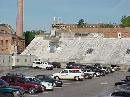
The spatial thinker looks at the world in spatial terms, inquiring about the "whys of where." I was once invited to speak at North Carolina State University (NCSU) in Raleigh. Upon my arrival, the above scene immediately struck me as odd, prompting me to take a photograph. Why would stadium bleachers be overlooking a parking lot? The spatial thinker also thinks temporally, realizing that spatial objects change over time. One logical conclusion was that the parking lot had been built upon a former athletic field. When was this done? What will it look like in the future? The situation suggests that it won't be long until the bleachers are torn down.
Why was the athletic field paved? Was the campus expanding, necessitating additional parking? Was campus expansion related to national trends? Was it population growth in the region? Or was a particular NCSU program suddenly in higher demand? If the field was not protected as a historical site, why not? Was a new stadium built elsewhere?
I also took this photograph of the village of Elham, located in the North Downs in southeast England. The village was first mentioned as Ulaham in an Anglo-Saxon charter of 855 A.D. Why was Elham settled in the center of the Elham Valley instead of on one of the surrounding hillsides?
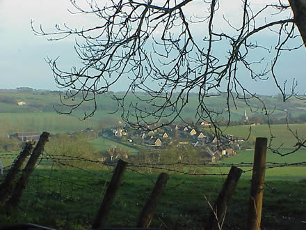
Elham was settled near the river for the same reason most towns are: for access to water for diversion to the fields for growing crops and watering livestock, and later for river transportation.
Yet we must not stop at considering why. We must also consider how. How was the decision made whereby a parking lot was deemed more important than an athletic field? What is the best way to test these hypotheses? Incorporate another how through methods: gather field data through the use of historical and current campus maps and by conducting interviews on campus. These considerations represent one more way of conceptualizing spatial thinking.
Habits of Mind
Spatially literate people should have an understanding of spatial concepts and have spatial skills attached to their tool belts. However, there is more to a spatially literate person. According to the National Research Council's report, Learning to Think Spatially, spatially literate people should also have the "habit of mind" of thinking spatially, which means knowing where, when, how, and why to think spatially.
Most people I know in the spatial learning and geotechnology education communities fit this characteristic to a tee. They seem to know why to think spatially, because they seek opportunities to advocate the importance of thinking spatially beyond education into society. They seem to know how to think spatially, do so from many viewpoints, and do so throughout the day: When reading a map of airline routes in an in-flight magazine, they may consider network analysis, regional transportation, and tourism's impact on the environment. When the buds burst forth on trees, they may ponder the effect of latitude, altitude, and climate on the speed of the arrival of spring. When looking at a menu, they may speculate about diffusion and how restaurant franchises decide in which cities to locate. When going hiking, they may mark waypoints with their GPS, take photographs, and make sketches, thinking about how the landscape has changed in the past and how it will change in the future.
How did the spatial and geotechnology education community develop these habits of mind? Many claim that since childhood, they have always loved maps, geography, or both. Childhood vacations and exploring a vacant lot over the fence may have served to bolster this affinity. However, in most cases, a primary or secondary school class or university program of study has nurtured this love into a lifelong way of thinking and acting. Therefore, educators have the important job of inspiring students, the decision makers of tomorrow, to think spatially—and not just in their GIS or geography classes but throughout their days and throughout their lives. Yes, educators have the opportunity to shape these habits of mind.
I welcome your thoughts about what spatial thinking is and how it can be effectively incorporated into education.
Joseph J. Kerski (jkerski@esri.com)