GIS Day: Great Experiences Everywhere
By Leslie Roundy, Esri Writer
"It was one of the best experiences I've ever had."
That sentiment, expressed by Patricia Carbajales, geographer, GIS Projects, the University of California, Santa Barbara, probably sums up how many GIS Day event hosts feel now that their celebrations are over and they've had time to reflect on the outcome.
GIS Day 2009 was celebrated at more than 1,000 sites around the world. It is rewarding and inspiring to read how event hosts celebrated the day and took advantage of the opportunity to share their knowledge and passion for GIS with others. A few examples follow:
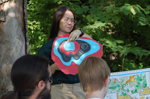 Rock Bridge Memorial State Park ranger Kathryn DiFoxfire led campers and chaperones through orienteering exercises and cave mapping and exploration in Connors Cave. |
For her GIS Day event, Carbajales held an interactive seminar with fourth and fifth graders at McKinley Elementary School in Santa Barbara to introduce them to GIS. Using her laptop and with the help of a volunteer, they played the Treasure Hunt game available on the GIS Day Web site as a group exercise.
"The students' response and enthusiasm were what made it so special to me. The event was such a success that I am planning to repeat it next fall," Carbajales said.
Do More with Less was the theme for the North Bay GIS User Group's event in Santa Rosa, California. "In the current economic times, we all need to do more with less," said Kevin Lacefield, GIS programmer analyst for the County of Sonoma. "The goal for our GIS Day event was to show area businesses and decision makers how GIS can help them do that." The event was open to the public and featured presentations, demonstrations, a map gallery, and a student map contest. Also included were facilitated panel discussions on the economic benefits of GIS for business leaders, how to get educated in the field of GIS, and how governments use GIS.
The New Mexico State University (NMSU) Geography Department hosted the first known GIS Day event held primarily in a virtual world. Using Linden Lab's Second Life, an immersive 3D virtual environment, students met in NMSU's Island learning community to share projects and posters demonstrating their GIS class activities with attendees in both the real and virtual worlds. Students were available throughout the day to describe their projects and help educate those not familiar with GIS about the technology. The event was mainly designed for university educators interested in the use of Second Life as a venue for teaching GIS, but it was open to everyone.
The highlight of Indiana University's (IU) GIS Day celebration was the keynote presentation by Elinor Ostrom, the 2009 Nobel Prize Laureate in Economic Sciences. Professor Ostrom's presentation was entitled Using GIS and Remote Sensing to Study the Effects of Diverse Institutions and explored the broader implications of mapping and geographic technologies. An IU faculty member since 1965, Ostrom was the first woman to win the Nobel Prize for Economics, established in 1968.
Other activities at the IU event included a variety of informational booths to show off the work that Indiana researchers and staff, businesses, and government agencies are doing with GIS. GIS professionals from the Bloomington area showcased topics including the IndianaMap, deforestation and reforestation studies, environmental applications, and mapping services for the City of Bloomington and Monroe County. Other professionals and educators talked with attendees about the GIS job market, training opportunities, and Internet mapping.
 Participants in GeoTech camp, hosted by the University of Missouri's Department of Geography, spent three days learning about mapping and geospatial technologies. |
Also included was an innovative "Earth as Art" contest, which showcased images of the Earth with an artistic perspective. Open to the general public, participants were encouraged to base their artwork on geographic data, imagery, or map features from around the world.
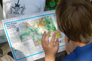
Dr. Shannon White of the University of Missouri's Department of Geography hosted a three-day GeoTech camp for sixth through ninth graders focused on mapping and geospatial technology tools that assist in geographic analysis. Students participated in many hands-on and outdoor activities related to geography and mapping, which included making their own compasses, creating their personalized life maps (where they had been and where they want to go), exploring aerial and satellite images, and importing their own GPS data into GIS software to create their own maps. In addition, campers used GPS units to locate a geocache on campus and collect waypoints while orienteering at Rock Bridge Memorial State Park in Columbia, Missouri.
Kathryn DiFoxfire, a member of the Rock Bridge interpretive staff, led the campers and geography chaperones through orienteering exercises and cave mapping and exploration in Connors Cave.
Other GeoTech camp partners included the United States Geological Survey (USGS), which provided take-home resources and maps, and Esri, which provided free GIS software for each of the campers.
The Overseas School of Colombo in Battaramulla, Sri Lanka, is a small school of about 400 K-12 students. It is unique in that many of the students' parents use GIS as a tool in development and relief work in Sri Lanka for organizations including the United Nations Development Programme, UNICEF, the World Health Organization, and the World Food Programme (WFP). To celebrate GIS Day, Ian Lockwood, the environmental systems and geography teacher at the school, asked a few of these "in-house experts" to give his students in grades 10, 11, and 12 presentations on the use of GIS in development and humanitarian work. A parent who works for the International Water Management Institute gave a presentation on how GIS is used to better manage water resources. Two parents affiliated with the WFP discussed how they use GIS as an indispensable tool to plan and act on emergency food needs across the world. The celebration also included a map gallery for students, teachers, and parents to observe and appreciate.
For its GIS Day celebration, the Pulaski Area Geographic Information System (PAgis) in Little Rock, Arkansas, chose the theme Developing Central Arkansas Using GIS. The event showcased how GIS technology has advanced economic development in the region and state. A key participant was Arkansas State Senator Shane Broadway, who gave a presentation, The Importance of GIS for Economic Development, in which he discussed the impact GIS had on a recent project in Saline County. The event also included a demonstration by the Arkansas Geocachers Association, poster and map displays, and demonstrations including one given by area high school students on how students utilize online GIS resources.
Mark Your Calendar
GIS Day 2010 will be November 17. It's never too early to start planning. For inspiration, visit www.gisday.com/success to find out how other organizations and individuals celebrated last year.