Esri Supports Guyana's Low-Carbon Development Strategy
By Barbara Shields, Esri Writer
In an effort to mitigate the effects of climate change, the South American nation of Guyana is developing the world's first national Low-Carbon Development Strategy (LCDS) using enterprise GIS technology and expertise from Esri. The GIS technology company will provide Guyana with software for use in national carbon accounting and sustainable management of forests.
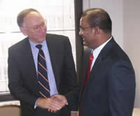 In a meeting with Guyana's President Bharrat Jagdeo, Esri President Jack Dangermond committed Esri to support the country's Low-Carbon Development Strategy. |
In a national announcement, Guyana's President Bharrat Jagdeo, described the goal of LCDS: "Our low-carbon strategy combats deforestation, a factor contributing to climate change, without slowing down national development or compromising our people's sovereignty over the forest. The emerging carbon market provides us with a unique opportunity to use the global economy to save the world's rain forests by putting a value on them."
Esri President Jack Dangermond met with President Jagdeo at the Office of Guyana's Permanent Mission to the United Nations and committed Esri to support the country's LCDS initiative.
"Esri's commitment brings vital technology for studying the effects of the forest on the planet," said President Jagdeo. "The combination of GIS software, training, and other capacity-building efforts will provide Guyana with the tools it needs to scientifically measure and analyze our natural resources effectively. With GIS, we can support responsible resource management decisions that benefit generations to follow."
"Esri's support stems from a longtime goal to advance sustainable environments and economies," noted Dangermond. "GIS has become an integral component in the development of new carbon accounting methodologies. It adds the rigor of science to a decision support system that validates a credible carbon exchange mechanism."
The government of Norway, the World Bank, the Clinton Climate Initiative, and McKinsey and Company are working with Guyana to implement the LCDS. Norway is one of the key countries backing Guyana's move to use its forests for carbon financing and payment for forest conservation now. This arrangement allows future innovations, including an eventual forest carbon credit system as such a market evolves. This strategy aligns with the United Nations Collaborative Programme on Reducing Emissions from Deforestation and Forest Degradation in Developing Countries (UN-REDD), a climate change mitigation program. This collaborative created a multi-donor trust fund that allows donors to pool resource deforestation via a finance mechanism that pays developing countries for conserving their tropical forests.
GIS is the core technology of Guyana's monitoring, reporting, and verification (MRV) system. Building on work done in country, the MRV will integrate field observations with satellite imagery and other geographic data using methodologies consistent with the Intergovernmental Panel on Climate Change (IPCC) guidelines for measuring, reporting, and verification. Guyana's MRV will be a system for data sharing and the cross-sector analysis essential for effective climate change research, mitigation, and adaptation planning. This enterprise approach enables the transparent disclosure of land-use dynamics and the status of natural resources for Guyana's citizens, indigenous communities, investors, partners, and the international carbon science community.
Esri continues to work with countries around the world, such as New Zealand, Australia, Canada, and the United States of America, to design solution models that offer a credible scientific approach to measuring, reporting, and verifying carbon emissions and sequestration. These systems incorporate Esri's robust imagery management, integrated workflows, spatial modeling, and analysis capabilities to help countries use reliable data and consider scientific evidence in their decision-making processes.
President Jagdeo presented Guyana's LCDS at the 2009 United Nations Climate Change Conference in Copenhagen, Denmark, last month. Representatives from participating nations discussed establishing emissions targets for industrialized countries and a method for financing mitigation and adaptation actions by developing countries.
Esri has a longtime commitment to protecting the earth's environment. Many scientists, policy makers, urban planners, foresters, agronomists, and others now use ArcGIS to study earth's changing climate and to make a positive difference. Read their stories at www.esri.com/climate.