Palm Oil Plantations Threaten Sustainable Living for Humans and Orangutans
By Barbara Shields, Esri Writer
 Willie Smits, biologist and environmentalist, talks about sustainable economies and the survival of biodiversity. |
"We can use technologies such as GIS to save biodiversity. We can still help local people retain their cultures and traditional means of existence." This is the message of Dr. Willie Smits, founder of the Borneo Orangutan Survival Foundation and the Masarang Foundation, which raise money and awareness to restore habitat forests around the world.
Smits is a biologist dedicated to rebuilding orangutan populations and improving forest habitats worldwide. His campaign is on two fronts. One is a zealous battle against deforestation and habitat destruction, and the other is the promotion of sustainable agribusiness that benefits two species of primates, human and orangutan. "We cannot save the environment if we do not simultaneously take care of people's needs," maintains Smits.
In recent decades, palm oil plantations have become prevalent on the Indonesian islands of Borneo and Sumatra, where, for thousands of years, colonies of orangutans have thrived in lush tropical forest. The main goal of the Borneo Orangutan Survival Foundation is to protect orangutans and their natural habitat, but the desecration of this habitat has become so pervasive that the foundation has taken into its care more than 2,000 orphaned orangutans, almost 1,000 of which are, at present, awaiting a chance for release into the wild. Scientists estimate that wild orangutans are disappearing at the rate of 2,000 a year and will be extinct in 10 years.
 Esri's ArcGIS combines Landsat, flyover route, and aerial imagery data to reveal locations of probable illicit timber operations (yellow circles). |
Smits uses Esri's ArcGIS software to identify the expansion of oil palm plantations and the harvest of palm oil as the main cause of the destruction of Indonesia's ecosystems. Palm oil, easily grown in these areas, is used in a wide range of products, from cookies to cosmetics. Demand is high, making the oil palms a major cash crop for Indonesia. But it is not a sustainable product to harvest because oil palms deplete the soil of nutrients and must be cut down for harvest, thereby ravaging the land.
GIS also clearly reveals illegal logging, clear cutting, and uncontrolled burning associated with oil palm operations that destroy the tropical rain forests and severely threaten the orangutans with extinction. "Destroying forests leaves orangutans with no food and no place to run," says Smits. Furthermore, the oil palm tree cultivation provides an easy inroad for illegal logging of other valuable rain forest timber and opens access for the atrocities of animal trade.
Smits combines satellite imagery and GIS to show changes both on forests and on humans. The technology is used to challenge the hypothesis that Borneo can indefinitely continue supporting oil palm plantations; to show the profit and cost factors of these sites and their proximity to transportation and shipping; to assess the precision farming factors of soil, elevation, and climate and their relationship and infringements on local communities; and to disclose property ownership disparities.
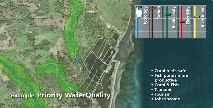 Sugar palm potential analysis tool shows water priorities required for a possible site. Slider tools show other value factors, from carbon sequestration to investment opportunity. |
SarVision has deployed SPOT imagery at 1 x 1 kilometer resolution for all of Indonesia to show how forests are receding and ground cover is changing from trees to shrubs and weeds. It is also used to reveal corruption by showing where companies say they are cultivating palm oil but, in fact, are clear-cutting high-quality rain forest. Some images reveal a conspiracy between timber and oil palm businesses running covert timber operations. Flyovers above suspect areas provide aerial images that pinpoint logging equipment in areas where it should not be. The eye of satellite imagery and the analytic ability of ArcGIS reveal these schemes and force the hand of law enforcers to take action. Moreover, remote-sensing imagery and GIS are proven tools for convincing various governments around the world that palm oil consumption is indeed destroying these precious forests.
"By using GIS, we were able to demonstrate in a very convincing way that people were misusing oil palms to get their hands on timber," says Smits. "More than half of permitted oil palm plantations in Central Kalimantan are located on unsuitable land for oil palms. But they are located in areas where formerly highly profitable forests were growing. GIS is extremely important for visually relaying this information. I don't need to give complicated explanations of the problem because people can easily understand what is happening from our maps. They see how fast the forest has shrunk in just three years. This leads them to wonder what the rest of the world will look like in 10 years."
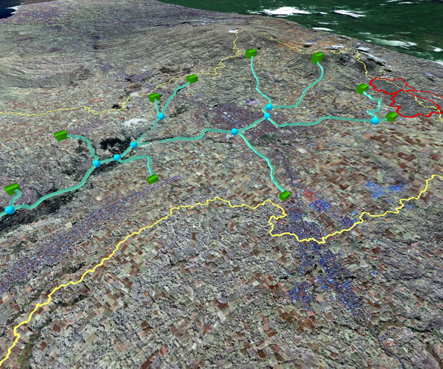 Tube network gravitationally transports the sugar palm ethanol product from village production centers to the coast for shipping. |
Because the Indonesian economy is so tied to the cultivation of palm oil, Smits must do more than preach conservation—he has to promote an economically feasible alternative. Smits studied sustainable options and cited sugar palm, which is a multipurpose plant that is edible and can be used for creating ethanol. "It uses little water, needs no artificial fertilizer, and is six times as productive as sugar cane," claims Smits. Since harvesting processes tap the sugary juices of the sugar palm's flowering branches rather than removing parts of the tree as does the palm oil harvest, the process retains the forest land's fertility.
GIS is part of the sugar palm remediation plan. It helps direct the activities of a cooperative of more than 6,200 farmers and shows them where and when to extract the palm's liquid. The technology also shows the best roads for oxcart to automobile transport, processing points in the village hubs, and pipeline placement for gravitational transmission of the product down to the coast for export. GIS shows microclimates and different soil types, as well as predicts yields. The outcomes of the analyses become the source for determining the amount of labor needed for planting and cultivation. It also provides a basis for estimating how much a sugar palm operation could cost. GIS also is useful for calculating the carbon sequestration rates of Indonesian forests, a valuable analysis for obtaining funding from programs concerned with climate change.
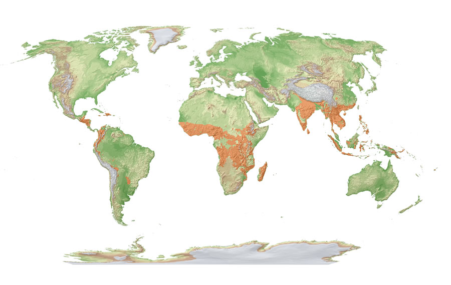 Sugar palms can be grown for sustainable development in these areas around the world. |
"We have mapped all of Borneo's forests to study the suitability of sugar palms," Smits explains. "We are using these same processes in other parts of the world, such as in Colombia, where we have a pilot project that includes one million sugar palms. We are looking at the worldwide potential, looking where the temperature and rainfall are sufficient, the infrastructure is in place for cultivation, and the human resources are large enough to perform the labor-intensive tapping processes. We have located many places throughout the world where sugar palms can be economically planted without depleting the soil. Among the GIS design tools are models for assessing site suitability and predicting impact on local hydrology, carbon storage, and the biodiversity of the area. GIS also indicates the best location to plant the palms and when it is seasonable to do so. GIS is a valuable tool for showing what has happened and designing plans for change."
Read more online about Willie Smits' work at www.redapes.org and the Masarang Foundation at www.masarang.org. Download Willie Smits' keynote address at the Esri International User Conference plenary.