Why and How Is GIS Used in Education? Find Out at the Esri Education User Conference in June
By Joseph J. Kerski
Teaching about GIS, Teaching with GIS
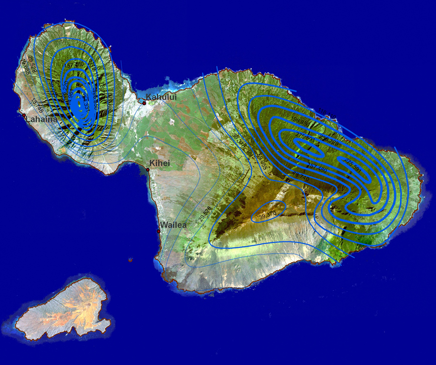 This map of rainfall isolines atop a Landsat image of Maui, Hawaii, illustrates why educators teach with GIS: Students can readily uncover relationships and patterns from processes operating on our world—from local to global scales. In the map above, the amazing range of rainfall—from 250 mm annually to 11,000 mm annually, over a very short distance—is evident in the colors shown on the satellite image. Rainfall also affects the land cover, land use, historical and current settlement, aquifers, stream flow, and landslides. |
There are three ways to think about people using geographic information system (GIS) technology in education. Some educators are teaching about GIS—the theories and fundamentals behind geographic information science (GISc) and the skills necessary to employ spatial analysis tools and GIS functions. Other educators are teaching with GIS—using spatial thinking and technologies to teach topics in geography, mathematics, history, environmental studies, earth science, chemistry, biology, and other disciplines. Both of these methods are growing in societies around the world.
Educators who teach about GIS do so for many reasons. Issues in your community, your region, and your world might include traffic, population growth, urban sprawl, energy, water resources, crime and terrorism, epidemics, the economy, biodiversity loss, sustainable agriculture, or ecotourism. These issues are growing in complexity, exist at every scale, and affect our everyday lives. These and every other pressing concern of our time include a spatial component. GIS is seen as the most effective technology to equip people so that they can make wise decisions about the earth. GIS courses, degree programs, and certificates are available at nearly all universities and colleges as well as online. The courses are taken by students studying a broad array of disciplines including environmental studies, business, geography, GISc, biology, engineering, and earth science. The number of students taking GIS courses each year in the United States alone is certainly in the tens of thousands and worldwide may exceed 100,000, according to Michael Goodchild's article The Fourth R? Rethinking GIS Education in the Fall 2006 issue of ArcNews.
Furthermore, the demand for GISc theory and skills has seen enormous gains and is expected to increase for quite some time, according to the U.S. Department of Labor. The president's Job Growth Training Initiative is a strategic effort to prepare workers to take advantage of new and increasing job opportunities in high-growth, high-demand, and economically vital sectors of the American economy. This initiative funds 14 job sectors including geospatial technology.
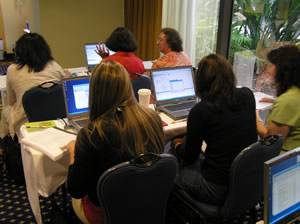 Educators receive some hands-on training in analyzing neighborhood demographic data within ArcGIS at the 2006 Esri Education User Conference (EdUC). |
Educators who teach with GIS do so because they see the value in incorporating spatial thinking and geotechnologies in education. GIS provides for active, student-centered, project-based learning that focuses on geographic inquiry-asking geographic questions, gathering geographic data, analyzing geographic issues, and solving geographic problems. GIS provides opportunities for authentic practice-assessing students via presentations and portfolios, just as they are evaluated in the workplace. Because GIS-using students are examining issues in the community and interacting with community members, it is seen as excellent citizenship education. Students use real-world data in real-world contexts to address real-world problems. Educators see the use of GIS as being an excellent example of the use of constructivism—a learning theory—which holds that, rather than being transferred from teacher to student, knowledge is constructed by the learner based on his or her own experiences. The school-to-career movement; funding from the U.S. Department of Labor; and content standards that focus on visualization, active learning, and processes, along with the information and technical literacy that GIS provides, are other incentives for teachers teaching with GIS. Lessons created by educators around the world, some of which are in the Esri ArcLessons library, illustrate community-based, open-ended projects that are interdisciplinary. These projects help students use the same technologies as are used in research and business to enhance motivation and learning, help them investigate the world, and help provide real employment skills.
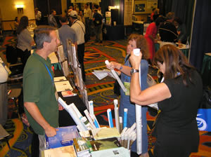 The EdUC EXPO is an excellent place for discovering new people, products, tools, and opportunities from nonprofit organizations, private companies, government agencies, and educational institutions around the world. |
The third group of people who use GIS in education does so to manage or analyze some component of education such as routing school buses, planning new schools, and analyzing test scores.
Because of developments in educational GIS, by the 1990s, conferences were needed to bring the GIS education community together. The Technological Education Research Center (TERC) hosted the first GIS in education workshop in 1994, followed by conferences for educators in Baltimore, Maryland, and Ypsilanti, Michigan, and in 2000 with the first Esri Education User Conference (EdUC) at California State University, San Bernardino.
The Esri Education User Conference
Since 2001, EdUC has been held at the San Diego Convention Center, running immediately before and concurrently with the first half of the Esri International User Conference. EdUC offers a forum for people who are teaching, writing curriculum, conducting educational research, and supporting education. This forum brings together educators from universities, community colleges, technical-vocational institutions, and secondary and primary schools as well as those in informal settings ranging from after-school clubs to national programs. EdUC is for people teaching about GIS, for people teaching with GIS, and for people in education who use GIS on the job. EdUC welcomes educators, researchers, support staff, and students. In 2006, 100 students using GIS and GPS in 4-H clubs came from across the United States and amazed the rest of the conference attendees with their professionalism and the topics they were examining. EdUC featured four days of workshops and presentations and an education exhibition. Nearly 800 attended, representing 50 states and 35 countries.
 Happy faces as another presentation begins at the Esri EdUC. |
The number of researchers and practitioners using GIS in education is growing, but it is still a relatively close-knit community. The conference has a family feel to it. No casual users here—everyone who is interested in teaching and learning with GIS seems passionate about what they do.
The 2007 Education User Conference
The 2007 EdUC will be held June 16–19, 2007, at the Marriott Hotel and Marina, adjacent to the San Diego Convention Center in San Diego, California. Sessions will include presentations; meetings on secondary school implementation and research; and hands-on workshops on data, tools, software, and pedagogy. Register here.
What can you do at EdUC? Not only can you discover new GIS tools, products, lessons, and books, but you'll have the opportunity to use them in hands-on workshops. You can learn how GIS is used in different disciplines that you may not have been aware of before and explore new teaching materials for using GIS in your classroom. You can network with hundreds of your colleagues and meet educators from around the world. The conference will include tracks such as GIS for School Planning and Administration and Using GIS in Libraries. You can bring your questions about data, pedagogy, and implementation to Esri staff for one-on-one discussion and troubleshooting. You can discuss your project ideas with Esri staff and others plus brainstorm ideas for new lessons with people who know how to teach GIS effectively. You will find out about industry trends and educational research. If you are new to GIS or even to the notion of what spatial thinking is, an Introductory track at the 2007 EdUC will include Web mapping tools, a GPS field trip, and work with hands-on lessons written by educators for educators.
The EdUC is really two conferences in one by including the first two days of the Esri User Conference (Esri UC). Last year, this event brought more than 13,500 people together from 127 countries and almost every conceivable employment sector. The EdUC and Esri UC give the clearest indication that I can think of in society about the diversity of GIS applications, the growth of geographic information sciences, the high degree of enthusiasm from the GIS user community (1,200 user papers, 100 special interest group meetings, dozens of regional user group meetings), and the growth of GIS over the past 30 years.
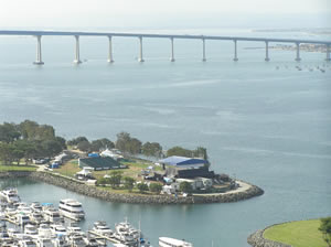 One of the best things about EdUC is that it is held in San Diego, adjacent to the beautiful San Diego Bay. Attending the event provides a great opportunity to combine a local field trip with the conference! |
Where else besides the Esri UC and EdUC can you learn about the power of spatial thinking and GIS in every major sector of society, at scales from local to global, taking place all around the world? Where else can you meet authors of textbooks or receive training from those who developed the software we are using?
The Esri UC and EdUC are incredible learning and networking experiences. The contacts gained there and the relationships and partnerships nurtured often last for years after the conference ends. While I always feel humbled by the end of the Esri UC in terms of my own knowledge base, it is good to realize that we are all learning and moving forward.
Final Thoughts
I encourage you to give serious consideration to attending EdUC this year. There are many low-cost lodging choices in San Diego. You will be humbled, amazed, and encouraged, all at the same time. You won't regret it. Even if you cannot attend, I commend your interest in GIS education and encourage you to find other opportunities to network with your colleagues. I hope to see you there!
About the Author
Dr. Joseph Kerski is education industry curriculum development manager on the education team at Esri in Denver, Colorado. Contact him at jkerski@esri.com or by calling 303-449-7779, extension 8237.