Esri Developer Summit Offers Expertise on How to Build Geospatial Applications
Development Staff Will Update Attendees on the ArcGIS 9.3 Release
Whether they want to learn advanced coding and design techniques to build server GIS solutions or find out how to develop custom tasks for ArcGIS Explorer, developers will get the know-how at next month's Esri Developer Summit (DevSummit).
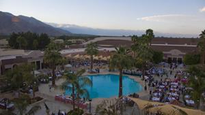 Palm Springs will once again serve as the venue for the DevSummit. |
The event, in its third year, will be held March 17–20, 2008, with developers returning to Palm Springs, California. Alan Cooper, a pioneering software inventor, programmer, designer, and theorist who is known as the "father of Visual Basic," will give the keynote address on March 19.
ArcWatch editor Carla Wheeler recently spoke with Rob Elkins, a DevSummit organizer who also works as a product manager for ArcGIS developer products. Elkins explains why attending the summit will be highly worthwhile for developers both new to and familiar with working with Esri's technology.
Wheeler: How has the DevSummit grown and changed since the first one was held in 2006?
Elkins: In year one, it was very successful, with about 600 or 700 people attending. Last year, attendance practically doubled. It was an exciting atmosphere. Many developers were new to Esri and eager to know more about GIS. They were interested in learning about geospatial technology, mapping applications, and solutions based on geographic data and locations. This year, we are on pace to draw more than 1,500 people to the Palm Springs Convention Center and Wyndham Hotel.
Wheeler: What's attracting developers who are new to Esri technology?
Elkins: They're interested in server and mobile technologies; another benefit they see is that Esri uses standard developer technologies: Java, J2EE, and Microsoft's .NET Framework. They've been able to leverage their existing Java skills or their .NET skills and have not had to learn a special proprietary language. They can use those skills to very easily build a mobile mapping solution, for example, or to integrate some mapping or some spatial location analysis into a Web application. A lot of Web developers and mobile developers want to integrate geographic analysis into their enterprise system to help make better business decisions.
Wheeler: What fields do they work in?
Elkins: They're coming from the commercial industries such as banking and insurance. We already have a lot of users in the utility industries. But more oil and gas companies and water and wastewater and electric and power utilities are sending their enterprise developers to the summit to help get them engaged in their organization's GIS and mapping divisions.
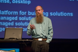 Scott Morehouse, Esri director of software development, addresses last year's DevSummit audience. |
Wheeler: Where do many seasoned Esri users come from?
Elkins: Cities, counties, and states including those from assessors' and recorders' offices and public works departments. They need to share information with the public over the Internet and therefore are interested in the capabilities of ArcGIS Server. They also want to share GIS knowledge with other information workers inside their organizations. So they have been building custom ArcGIS Engine applications or mobile solutions-based on ArcPad—to make it easier for the non-GIS professional to have access to the enterprise information.
Wheeler: What will the buzz be at the DevSummit in regard to some of Esri's new technology?
Elkins: The excitement is going to be around the release of the ArcGIS 9.3 software, since we will be in beta by the time the summit begins. All Esri Developer Network (EDN) subscribers will be given access to the beta software. ArcGIS 9.3 is a great release for the Web developer because of the enhancements to the .NET and Java Application Developer Framework (ADF) for building interactive and enhanced Web applications. Also, we will have new JavaScript API's that will allow you to very easily publish and share data from ArcGIS Server and integrate it with other data sources. With ArcGIS Server 9.3, you'll be able to create mashups that leverage Microsoft's Virtual Earth or Google Maps basemaps, plus the geoprocessing power of ArcGIS Server.
Wheeler: This year's DevSummit will begin with a series of preconference seminars. What are those?
Elkins: The summit will officially open on Tuesday, March 18, but all attendees are encouraged to attend preconference seminars on Monday, March 17, at no additional charge. These preconference sessions serve two purposes. The first is to help developers new to GIS come up to speed on all our different products and technologies so they will have the background to better understand the information presented on Tuesday, Wednesday, and Thursday. We also realize that some people who are using Esri technologies do not have the latest software versions or have not fully leveraged the geoprocessing framework or the geodatabase. So we will have sessions to familiarize existing users with the latest versions and technologies so they can be ready for the intermediate and advanced technical sessions that will follow.
Wheeler: Will there be a Plenary Session this year?
Elkins: Yes, the plenary will be Tuesday morning but will only last two rather than four hours. We will look ahead to the next 12 months—where we are now with the ArcGIS 9.2 release, what's coming at ArcGIS 9.3 with ArcGIS Server, enhancements to ArcGIS Desktop and the geodatabase, and where we are moving forward with ArcGIS 9.3 and beyond. We will also have some demonstrations and coding presentations.
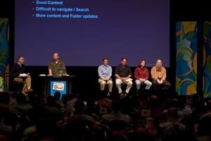 Esri President Jack Dangermond (far left) and his senior staff present a panel discussion at the DevSummit. |
Wheeler: How many technical sessions will you have this year?
Elkins: We'll host 45 to 50 different technical sessions. Plus, this year we've added three super sessions on Tuesday morning: one for ArcGIS Server, one for ArcGIS Desktop and ArcGIS Engine development, and one for ArcGIS Online for developers. Those three sessions will lay out a road map for the rest of the technical sessions. We also plan to repeat key sessions this year, as we realize you can't be in two or three sessions at the same time.
Wheeler: Give me an overview of the sessions.
Elkins: We will have three types of sessions. The first one is on core technologies. I think there will be a lot of interest in some of the core fundamentals of building a high-performance Web application—an application that can scale, performs well, and is easy to build and maintain. I also think there will be interest in geoprocessing-the geoprocessing framework-how you can create a model with ArcGIS Desktop and make it available on the Internet with ArcGIS Server or in a custom ArcGIS Engine application with Java or .NET. Our second type of session will revolve around enterprise solutions. The presenters will talk about real-world implementations—best practices from existing applications—and share those with developers who are trying to build similar solutions. The third type of session will focus on migration. Many people have ArcIMS sites and are investigating ArcGIS Server, so there will be a session on moving from ArcIMS to ArcGIS Server. Or they're exploring how to take a Visual Basic for Applications (VBA) customization of ArcMap and update that to a .NET solution. Or perhaps they want to move from Visual Basic 6 and older technology from Microsoft and start using Visual Studio and the .NET Framework. ArcGIS 9.3 will be supporting the latest versions of Java and of .NET, so I think there will be a lot of interest from our users in updating and upgrading to the latest technologies.
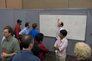 Informal Tech Talks will be held around white boards. Here developers can ask Esri's technical staff questions or bounce ideas off of them. |
Wheeler: Will developers still gather in the Community Center for the popular Tech Talks?
Elkins: The Community Center will return, but the Tech Talks with the presenters that follow each technical session will be closer to the room that hosts the session. That will make getting together convenient for everyone. For the first time, a demo theater will be set up inside the Community Center, where people will be able to watch 30- to 45-minute demonstrations of Esri technology.
Wheeler: Palm Springs seems to be a popular venue for the DevSummit. Why?
Elkins: In March, most places in the United States and around the world are still a little chilly. Palm Springs has beautiful weather. It's in the 60s, 70s, or, if we are lucky, even in the 80s. Palm Springs is known as a golf mecca for North America. The San Bernardino National Forest is nearby. So is Joshua Tree National Park, one of my favorite spots to go. It's a unique location—a great place for hiking and climbing around on the rocks.
Wheeler: How can people register for the DevSummit?
Elkins: People can register by visiting www.esri.com/devsummit. The deadline to register online is March 14, but they can also register on-site at the Palm Springs Convention Center when the summit begins.
To learn more about the DevSummit, listen to a podcast with Elkins and Jim Barry, the manager of the EDN Web site.
Alan Cooper, pioneering software inventor, programmer, designer, and theorist will give the keynote address on Wednesday morning of the DevSummit. Widely known as the "father of Visual Basic," Cooper has been helping companies invent powerful, usable, and desirable software for the last decade.