Colombian Telecommunications Company Solves Data Bottleneck with GIS
EDATEL, a telecommunications company based in Colombia's second-largest city of Medell�n, provides service to about 450,000 people in an area covering approximately 153,000 square kilometers. To succeed in Colombia's competitive telecommunications market, the company needed a way to manage outside plant data quickly and efficiently, better serve customers, and improve workflow. Their solution: A geographic information system (GIS) that interfaces with the company's business management systems and provides new abilities to design, plan, and manage the outside plant, as well as serve customers and plan marketing strategies.
EDATEL is owned by Colombia's largest public utilities group, Empresas Publicas de Medell�n (EPM). It provides basic and prepaid telephone, rural wireless telephone, PBX private phone, public phone, switched Internet, prepaid Internet, broadband access, and data transmission services. Prior to developing its GIS solution, EDATEL used a CAD-based tool to spatially manage service center calls and allocate network resources.
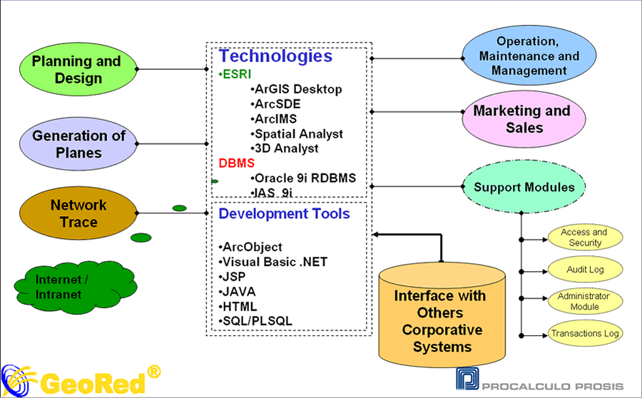
To learn how GIS could manage the company's data bottleneck, EDATEL contracted with Proc�lculo Prosis S.A., Esri's distributor in Colombia, to conduct a pilot study. The results convinced EDATEL's executive board to fund an enterprise project based on Esri ArcGIS technology. The resulting system is called GeoRed ("red" translates into English as "network"). Prosis converted the company's data into a georeferenced database and developed several intranet-accessible user modules for specific activities such as planning and design, operations maintenance and management, network tracing, map generation, and customer service and marketing.
This enterprise project employs ArcGIS Desktop and Esri server software. Data is managed by ArcSDE technology running on an Oracle database management system. ArcIMS technology supports easy access through the company's intranet. Analysis tools include network tracing and the use of Esri's ArcGIS Spatial Analyst for analyzing current and potential customer area densities and commercial service demand. Development tools used include ArcObjects, Visual Basic, .NET, and Java.
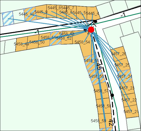 The box selection tool supports operation, maintenance and management activities by finding one or more service boxes on the map according to distributor and district and displaying areas of influence. Orange indicates areas of influence and the lighter blue lines indicate low risk properties. |
The different modules allow users to select the information they need for specific tasks. For example, the infrastructure module allows them to drill down from a view of the subterranean duct network to information about the copper and fiber wire inside the duct. In the operations maintenance and management module, they can view an inventory of the network and infrastructure and schedule automated notifications for maintenance and lifetime limits. In the plan generation module, drop-down menus help them select a specific geographic area of interest and produce a map of the selection showing details about the installed network and infrastructure as well as street and plot information. The map can be shared over the intranet or printed out for field use. Customer service employees use the customer module to search for people who have not paid their bills. They can then open up a screen that shows each customer's service details. This information is also used as a basis for estimating risk when considering where to expand new services. Another support for deciding where to expand is the ability to show details of where company expenses and returns will produce optimal results. For expansion cost estimations, engineers use GIS network design and cost-estimating tools to create the technical studies. Because of these new technical and marketing tools, expansion planning that previously took eight months now takes only two to three months. This new agility has helped the company to confidently grow its services.
"Since implementing our GIS solution, the company has significantly increased both its customer response time as well as improved its inventory management capabilities," says Jos� Rene Romero Bland�n, GIS manager at EDATEL. "GeoRed also has been very useful in helping us plan and implement our sales campaigns."
Intranet access also lets EDATEL employees create dynamic maps in real time, giving them fast access to the information they need. This has created a new "GIS culture" among many employees who now incorporate geography into their problem-solving processes.
"An environment in which people perceive the use of GIS as fundamental to successfully performing their daily tasks and achieving the company's long-range goals is a key component of the successful implementation of the system and preserves performance and reliability," says Romero.
| This map provides visualization of the percentage of use for each service box according to district and network center. Numbers indicate the box number and colors indicate percentage of current usage, from green (less than 20 percent to red (more than 80 percent. The black half-moon indicates a cabinet location, black-and-white rectangles indicate telephone exchanges, and blue dashes indicate the district boundaries. | 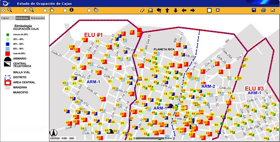 |
Implementing GIS has also allowed the company to incorporate tools such as handheld computers and Global Positioning System (GPS) devices that make information gathering in the field easier. In addition, integration with other enterprise systems, such as billing, inventory, and commercial EDATEL systems, helps promote productivity throughout the entire organization, particularly in the engineering and operations divisions. For example, time dedicated to compliance reporting (operating standards and customer response times) was greatly reduced from about three weeks to just five minutes.
Centralized data storage that provides easy information processing and access has made the company's design, operation, and maintenance activities more efficient and reduced transportation time and costs when working in the field. Increased reliability of technical information also has reduced hidden costs of using outdated information and improved timely response to customer calls.
For more information about this project, contact Jos� Ren� Romero Bland�n at jrromero@edatel.com.co or Carlos A. Cardona at ccardona@prosis.com.